
 Česky
Česky Deutsch


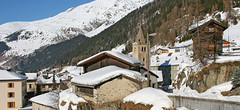
Bourg-Saint-Pierre is an important place on the Haute Route Chamonix-Zermatt. Starting point for the approach to the mountain huts Cabane Valsorey and Cabane Vélan.
Tours starting from hut
Ski tours around Hut Bourg-Saint-Pierre

- Country
- Switzerland
- Montains
- Walliser Alpen / Alpes valaisannes
- Open (winter)
- Beds
- 0
- Winterraum
- Shortening of access (cableway, lift, taxi, snowcat...)
- UTM / CH1903 x ("longitude" E/W)
- 582258
- UTM / CH1903 y ("latitude" N/S)
- 88682
- Map
- Arolla 283 S, Swisstopo 1:50000 Chanrion 1346, Swisstopo 1:25000 Mont Vélan 1366, Swisstopo 1:25000 Orsiéres 1345, Swisstopo 1:25000
- Guides
- Ski de randonnée Bas-Valais Die klassischen Skitouren (SAC, deutsch) Les classiques de randonnée à ski (SAC, francais) Walliser Alpen (Rother, deutsch)
- Phone (hut)
- -
- Phone (valley)
- -
- Cell phone
- -
- Web
- saint-bernard.ch
- bourg-st-pierre@st-bernard.ch
- Owner of hut
- -
- Avalanche danger
- www.slf.ch
- Weather
- Bourg St.-Pierre, meteoblue.com Bourg St.-Pierre, yr.no Combin Meitin, mountain-forecast.com Cab. Valsorey, Meteoblue.com Plateau Couloir, Meteoblue.com Gr. Combin Valsorey, mountain-forecast.com Gr. Tete de By, mountain-forecast.com Meteoschweiz SRF Meteo
- Snow report
- bergfex.ch, Liddes - Vichères
- Webcams
- Grand St. Bernard Tunnel
- Region
- Bourg-Saint-Pierre Wallis.ch Pays du Saint-Bernard
- Public traffic
- train SBB Bus - Postauto.ch
- Skiresort nearby
- Liddes - Vichères
- Other links
- Swiss Tourism
hut Bourg-Saint-Pierre - Reviews
There are no reviews in this section yet. Click the Add Review button to add first review.
Best ski tours in mountains Walliser Alpen / Alpes valaisannes, Switzerland
-

Alphubel 4206 m
Britannia Hütte Walliser Alpen / Alpes valaisannes Switzerland
- Length of ascent10 km
- ascent1450 m
- duration7-10 h
- Fitness difficulty ♦♦♦◊
- Technical difficulty ♦♦♦◊
ALPHUBEL (Britannia Hütte, Walliser Alpen) is seemingly lighter 4000vka, but over are dangerous glacial cracks. Ski alpinists can also go from the Saas Fee ski area, most not far from the cable car station Langfluh .

-

Col Valpelline, Day 6 H.R. Chamonix-Zermatt 3551 m
Cabane des Vignettes Walliser Alpen / Alpes valaisannes Switzerland
- Length of ascent9 km
- ascent1485 m
- duration8-10 h
- Fitness difficulty ♦♦♦◊
- Technical difficulty ♦♦♦◊
The last stage of the Haute Route Chamonix - Zermatt is an ode to skiing. After an easy ascent to three saddles - Col de Eveque, Col du Mont Brulé and Col Valpelline. Every ski mountaineer will be amazed by the panorama of the impressive 4000m peaks - Dent Blanche, Matterhorn and Dent d´Hérens. This is followed by a 10 km descent to Zermatt.
-
Strahlhorn 4190 m
Britannia Hütte Walliser Alpen / Alpes valaisannes Switzerland
- Length of ascent9,4 km
- ascent1250 m
- duration6-8 h
- Fitness difficulty ♦♦♦◊
- Technical difficulty ♦♦◊◊
Strahlhorn (Britannia Hütte, Walliser Alpen) is a classic glacier ski tour from Britannia Hütte. From the Adlerpass saddle, you usually go skiing to the top. To get off Saas Fee, take the Metro to the "window" at 3460 m to the Hohlaub Gletscher and start the ascent after a short ride.
Best ski tours in Switzerland by skitour.guru
-

Pizzi dei Rossi 3026 m
Fornohütte - Capanna del Forno Bernina Alps Switzerland
- Length of ascent3 km
- ascent665 m
- duration4,5-6 h
- Fitness difficulty ♦♦◊◊
- Technical difficulty ♦♦♦♦
Skialpová Pizzi dei Rossi je ideální volbou pro poslední den na chatě. Návrat na parkoviště pod Malojapassem má úplně jinou úroveň, než přesun údolím. Výstup z chaty vede často traverzy zápaního svahu, na jaře jsou haršajsny nutností. Náročný je až výstup prudkým svahem do sedla, většinou bude nutné nasadit mačky a lyže dát batoh. Ze sedla nalehko a bez lyží na vrchol. Sjezd severním kuloárem je zprvu velmi prudký a bmusí se projet zúžením mezi skalami. Dál po pláních je už luxusní svah a když je dobrý sníh, je to fantastický sjezd. Ten pokračuje i údolím Val Muretto až na planinu Canis. Pár krátkých protisvahů na kraj soutěsky a pak už zase jen dolů k mostu přes horskou bystřinu a po rovině na parkoviště.
-

Gletscher Ducan 3019 m
Davos Albula Alps Switzerland
- Length of ascent6,5 km
- ascent1360 m
- duration5,5-7 h
- Fitness difficulty ♦♦◊◊
- Technical difficulty ♦♦♦◊
The Ducan Gletscher is a summit with a wonderful view of the Piz Kesch and especially the Piz Ela. The ski tour starts in Monstein, where the highest brewery in Europe is located. The Fanezfurgga saddle leads to valley with a striking mountain. The end of the climb up is usually with ice axe and crampons. The descent through the Ducantal valley is oriented to the north and leads skiers into the Sertigtal valley. The route can also be done in the opposite direction. It is advisable to undertake the tour with the support of public transport.
-

Isenfürggli 2765 m
Davos Albula Alps Switzerland
- Length of ascent3 km
- ascent845 m
- duration2,5-3,5 h
- Fitness difficulty ♦♦◊◊
- Technical difficulty ♦♦◊◊
The ascent to the Isenfürggli saddle is a worthwhile addition after successful descents from Pischahorn or Isentällispitz. Especially in firn conditions or fresh powder, it is a rewarding destination. From the saddle, there is a beautiful view of the Silvretta range, with the striking Piz Linard as its centerpiece.