
 Česky
Česky Deutsch


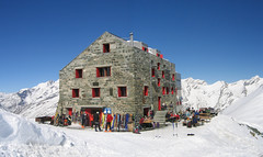


Excellent hut over Saas Fee skiresort (Wallis Alps), half an hour from the cable car. The starting point for five glacier tours - Fluchthorn, Strahlhorn, Rimpfischhorn, Allalinhorn and Alphubel.
Tours starting from hut
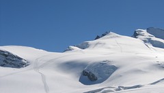
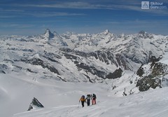
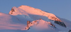
Ski tours around Hut Britannia Hütte
-

Alphubel 4206 m
Britannia Hütte Walliser Alpen / Alpes valaisannes Switzerland
- Length of ascent10 km
- ascent1450 m
- duration7-10 h
- Fitness difficulty ♦♦♦◊
- Technical difficulty ♦♦♦◊
ALPHUBEL (Britannia Hütte, Walliser Alpen) is seemingly lighter 4000vka, but over are dangerous glacial cracks. Ski alpinists can also go from the Saas Fee ski area, most not far from the cable car station Langfluh .

-
Fluchthorn 3802 m
Britannia Hütte Walliser Alpen / Alpes valaisannes Switzerland
- Length of ascent6 km
- ascent1000 m
- duration3-4,5 h
- Fitness difficulty ♦♦◊◊
- Technical difficulty ♦♦◊◊
Fluchthorn (Britannia Hütte, Wallis) is an optimal acclimatization tour for 4000 above Saas Fee and can be managed at the same time as the Strahlhorn.
-

Rimpfischhorn 4198 m
Britannia Hütte Walliser Alpen / Alpes valaisannes Switzerland
- Length of ascent12 km
- ascent1260 m
- duration7-10 h
- Fitness difficulty ♦♦♦◊
- Technical difficulty ♦♦♦♦
Rimpfischhorn is the most demanding ski tour of Saas Fee - Britannia Hütte (Walliser Alpen). Dangerous big cracks and at the finish climbing terrain.
-
Allalinhorn 4027 m
Britannia Hütte Walliser Alpen / Alpes valaisannes Switzerland
- Length of ascent3 km
- ascent580 m
- duration3-4 h
- Fitness difficulty ♦♦◊◊
- Technical difficulty ♦♦◊◊
ALLALINHORN (Britannia Hütte, Walliser Alpen) is one of the lightest 4000 in the Alps. By Metro in Mittelallalin and only 500 meters to the peak. In the case of excellent conditions the downhill slopes from the top west cross to the Feejoch.
-
Strahlhorn 4190 m
Britannia Hütte Walliser Alpen / Alpes valaisannes Switzerland
- Length of ascent9,4 km
- ascent1250 m
- duration6-8 h
- Fitness difficulty ♦♦♦◊
- Technical difficulty ♦♦◊◊
Strahlhorn (Britannia Hütte, Walliser Alpen) is a classic glacier ski tour from Britannia Hütte. From the Adlerpass saddle, you usually go skiing to the top. To get off Saas Fee, take the Metro to the "window" at 3460 m to the Hohlaub Gletscher and start the ascent after a short ride.
- Country
- Switzerland
- Montains
- Walliser Alpen / Alpes valaisannes
- Open (winter)
- march-may
- Beds
- 134
- Winterraum
- open, 12 beds
- Shortening of access (cableway, lift, taxi, snowcat...)
- by cableway from Saas Fee to Felskinn (Allalinexpres / Felskin)
- Card Pay
- EC cards acceptable
- Shower
- no
- Wifi
- no
- UTM / CH1903 x ("longitude" E/W)
- 638420 (CH1903)
- UTM / CH1903 y ("latitude" N/S)
- 101070 (CH1903)
- GPX access to hut (waipoints, track)
- BritanniaHuette Access SKITOURguru.gpx
- GPX all tours from the hut
- BritanniaHut CH WALLIS all_SKITOURguru.gpx
- Map
- Mischabel 284 S, Swisstopo 1:50000 Saas 1329, Swisstopo 1:25000 Monte Moro 1349, Swisstopo 1:25000 Randa 1328, Swisstopo 1:25000 Zermatt 1348, Swisstopo 1:25000
- Guides
- Walliser Alpen Ost (SAC, deutsch) Die klassischen Skitouren (SAC deutsch) Les classiques de randonnée à ski (CAS, francais) Walliser Alpen
- Phone (hut)
- +41 (0)27 957 22 88
- Phone (valley)
- 0041 (0)79 396 94 03
- Cell phone
- -
- Mobile Signal
- yes, but outside the hut
- Web
- -
- cabane.britannia@saas-fee.ch
- Owner of hut
- CAS Genevoise
- Britannia Hütte
- Start Point
- Saas Fee - Felskinn (cableway upper station)
- UTM / CH1903 x ("longitude" E/W)
- 636937
- UTM / CH1903 y ("latitude" N/S)
- 102036
- Altitude
- 2989 m
- Ascent (height difference)
- 1080 m
- Time of Access
- 0,5 h
- Shortening lift
- by cableway from Saas Fee to Felskinn (Allalinexpres / Felskin)
- Avalanche danger
- SLF - Oberes Saastal (Gefahrenkarte Regional)
- Weather
- SRF Meteo Meteoschweiz snow-forecast.com Meteoblue - Saas Fee yr.no - Saas Fee yr.no - Saas Fee
- Snow report
- snow-forecast.com bergfex.ch onthesnow.com snow.myswitzerland.com/ skiresort.info
- Webcams
- Mittelallalin Langflue Saas Fee
- Region
- Saas Fee Wallis/Valais
- Public traffic
- vlaky - SBB autobusy - Postbus
- Skiresort nearby
- Saas Fee
- Other links
- Schweiz Tourism
hut Britannia Hütte - Reviews
There are no reviews in this section yet. Click the Add Review button to add first review.
Best ski tours in mountains Walliser Alpen / Alpes valaisannes, Switzerland
-

Tour du Ciel - day 5 3030 m
Turtmannhütte / Cabane Tourtemagne Walliser Alpen / Alpes valaisannes Switzerland
- Length of ascent5,5 km
- ascent1110 m
- duration5-7 h
- Fitness difficulty ♦♦◊◊
- Technical difficulty ♦♦◊◊
A relatively easy ascent, though steep in places, from Lake Turtmannsee, which is reached by descending from the Turtmannhütte. From the summit ridge, there's a long descent to the Hotel Weisshorn, followed by forest trails leading down to the village of St. Luc - Chandolin in the Val d'Anniviers.
-

Pigne d´Arolla 3790 m
Cabane des Dix Walliser Alpen / Alpes valaisannes Switzerland
- Length of ascent6 km
- ascent1000 m
- duration5-7,5 h
- Fitness difficulty ♦♦◊◊
- Technical difficulty ♦♦♦◊
Pigne d´Arolla is a very popular and easily accessible viewpoint. The ski tour to the summit leads from the three mountain huts - Cabane Dix, Cabane Vignettes and Cabane Chanrion. The route from Dix goes around the glacial seracs to the saddle Col de la Serpentine and the summit can be reached on skis. A worthwhile summit on the Haute Routes to Zermatt.
-

Tour du Ciel - day 4 4153 m
Cabane Tracuit Walliser Alpen / Alpes valaisannes Switzerland
- Length of ascent6 km
- ascent1150 m
- duration5,5-7,5 h
- Fitness difficulty ♦♦♦◊
- Technical difficulty ♦♦♦◊
The stage begins at the Cabane Tracuit with an ascent of the 4,000-meter peak Bishorn, which is considered relatively easy. After skiing back down to the Tracuit hut, the route continues with a descent over the Turtmanngletscher glacier. A subsequent climb over the Brunegggletscher glacier leads into a rocky corridor, which marks the beginning of the descent to the Turtmannhütte.
Best ski tours in Switzerland by skitour.guru
-

Clariden E, from Claridenhütte 3267 m
Claridenhütte Glarus Alps Switzerland
- Length of ascent6 km
- ascent1025 m
- duration4,5-6 h
- Fitness difficulty ♦♦◊◊
- Technical difficulty ♦♦◊◊
After Tödi, Clariden is the second most popular ski tour in the Glarus Alps. The ascent leads along the gentle Claridenfirn glacier from Claridenhütte to the foot of Clariden and then through a wide northeast slope to the top pyramid. Beautiful views of the entire Glarus Alps and the neighboring Uri Alps. Descent copies the ascent track. A popular alternative is to continue crossing the Planura hut after descending the steep slope turn right to Claridenpass.
-

Chli Bielenhorn 2940 m
Andermatt - Realp - Oberalppass Urner Alps Switzerland
- Length of ascent8,5 km
- ascent1450 m
- duration5-6,5 h
- Fitness difficulty ♦♦♦◊
- Technical difficulty ♦♦◊◊
Chli Bielenhorn je skalnatá špička v říši monumentálních žulových stěn divokých hor. Začátek kolem silnice na Furkapass pokračuje po pláni pod chatou Albert-Heim-Hütte. Pak přichází v sousedství pohled na ledovce monumentálního Dammastocku. V kulisách skal vede logická linie ke skidepu kousek pod vrcholem. V případě stabilního sněhu je fajn alternativou sjezdová linie jižně od výstupové stopy a dále členitým terénem k hotelu Tiefenbach a v okolí silnice nebo po ní zpět do Realpu.
-

Piz Bernina 4048 m
Chamanna Boval / Bovalhütte Bernina Alps Switzerland
- Length of ascent7,5 km
- ascent1695 m
- duration8-10,5 h
- Fitness difficulty ♦♦♦♦
- Technical difficulty ♦♦♦♦
Piz Bernina is the only 4000m peak in the Eastern Alps. The greatest danger are the huge and numerous crevasses on the Morteratsch Glacier and the ridge to the summit. Piz Bernina sets off from Chamanna Boval or Rifugio Marco e Rosa on the plateau below the summit. Bernina is a demanding alpine challenge.