
 Česky
Česky Deutsch


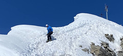
La Fouly is a mountain village in the Val Ferret. It is an important stop on the Haute Route from Chamonix to Zermatt, especially on the so-called Grande Lui variant over the Col du Grand Lui and further from La Fouly to the Grand-Saint-Bernard Pass. From La Fouly, you can also set out on ski tours to Mont Dolent and the summit of Grand Lui. There are several accommodation options, especially in the mountain lodge Gite d’Étape.
Tours starting from hut
Ski tours around Hut La Fouly

- Country
- Switzerland
- Montains
- Walliser Alpen / Alpes valaisannes
- Open (winter)
- December - mid April
- Beds
- 17
- Winterraum
- no
- Shortening of access (cableway, lift, taxi, snowcat...)
- accessible by car
- Card Pay
- yes
- Shower
- yes
- Wifi
- yes
- UTM / CH1903 x ("longitude" E/W)
- 573627
- UTM / CH1903 y ("latitude" N/S)
- 86901
- GPX all tours from the hut
- LaFouly_ALL_skitours.gpx
- Map
- Martigny 282 S, Swisstopo 1:50000 1365 Gd-St-Bernard, Swisstopo 1:25000 1345 Orsières, Swisstopo 1:25000
- Guides
- Ski de randonnée Bas-Valais Die klassischen Skitouren (SAC, deutsch) Les classiques de randonnée à ski (SAC, francais) Walliser Alpen (Rother, deutsch) Haute Route (Rother, deutsch) Haute Route Chamonix-Zermatt (JM editions, french)
- Phone (hut)
- +41 275650653
- Phone (valley)
- -
- Cell phone
- +41792933713
- Mobile Signal
- yes
- Web
- gitedelafouly.ch
- info@gitedelafouly.ch
- Owner of hut
- privat
- Avalanche danger
- www.slf.ch
- Weather
- La Fouly 1600 m / meteoblue.com Mont Dolent 3823 m / meteoblue.com Grande Lui 3509 m / meteoblue.com Mont Dolent 3823 m / mountain-forecast.com Grande Lui 3509 m / mountain-forecast.com SRF.ch SRF.ch - La Fouly Meteoschweiz
- Snow report
- Val Ferret - La Fouly, bergfex.ch Val Ferret - La Fouly, snow-forecast.com Val Ferret - La Fouly, onthesnow.com
- Webcams
- Tunnel Gd St Bernard Pays St. Bernard
- Region
- La Fouly Pays St. Bernard Wallis.ch
- Public traffic
- train SBB Bus - Postauto.ch
- Skiresort nearby
- Val Ferret - La Fouly Verbier
- Other links
- Swiss Tourism
hut La Fouly - Reviews
There are no reviews in this section yet. Click the Add Review button to add first review.
Best ski tours in mountains Walliser Alpen / Alpes valaisannes, Switzerland
-

Pigne d´Arolla 3790 m
Cabane des Dix Walliser Alpen / Alpes valaisannes Switzerland
- Length of ascent6 km
- ascent1000 m
- duration5-7,5 h
- Fitness difficulty ♦♦◊◊
- Technical difficulty ♦♦♦◊
Pigne d´Arolla is a very popular and easily accessible viewpoint. The ski tour to the summit leads from the three mountain huts - Cabane Dix, Cabane Vignettes and Cabane Chanrion. The route from Dix goes around the glacial seracs to the saddle Col de la Serpentine and the summit can be reached on skis. A worthwhile summit on the Haute Routes to Zermatt.

-

Alphubel 4206 m
Britannia Hütte Walliser Alpen / Alpes valaisannes Switzerland
- Length of ascent10 km
- ascent1450 m
- duration7-10 h
- Fitness difficulty ♦♦♦◊
- Technical difficulty ♦♦♦◊
ALPHUBEL (Britannia Hütte, Walliser Alpen) is seemingly lighter 4000vka, but over are dangerous glacial cracks. Ski alpinists can also go from the Saas Fee ski area, most not far from the cable car station Langfluh .
-

Bishorn 4153 m
Cabane Tracuit Walliser Alpen / Alpes valaisannes Switzerland
- Length of ascent4,5 km
- ascent950 m
- duration5-6,5 h
- Fitness difficulty ♦♦♦◊
- Technical difficulty ♦♦◊◊
Bishorn seems to be a relatively light 4000, but looks are deceptive. If you include the approach to Cabane Tracuit from Zinal in the ascent, it is quite a long ski tour. From the hut the ascent line leads slightly up the glacier Turtmanngletscher. Directly below the peak on the plateau you have to swap skis for crampons and comfortably climb to the panoramic summit - one of the best in all of Valais. Driving down the northern slope is usually a fantastic enjoyment, the risk of glacier cracks is minimal.
Best ski tours in Switzerland by skitour.guru
-
Pizzo Lucendro 2963 m
Rotondohütte Urner Alps Switzerland
- Length of ascent5,5 km
- ascent1090 m
- duration4-6 h
- Fitness difficulty ♦♦◊◊
- Technical difficulty ♦♦♦◊
Pizzo Lucendro je výrazný vrchol nad Gotthardpassem a také prvotřídní rozhledna. Na túru lze vyrazit z údolního Realpu, snazší je start z chaty Rotondohütte. Po sjezdu nad úroveň salaší nastává dlouhý výstup členitým terénem, který nabírá na strmosti. Těsně pod skalním sedlem je v úzkém koridoru zvládání otočky nutností. Za sedlem následuje poměrně snadný výstup do sedla, k místu, kde bývá depo lyží. Při výstupu po hřebeni k vrcholovému kříži pozor na převěje a místy exponovaný terén. Při sjezdu za jarního firnu se vyplatí počkat v sedle, než slunce změkčí stinný svah pro velkolepý odpolední sjezd západním svahem. Z nejnižšího bodu návrat na chatu nebo sjezd až do Realpu.
-

Tödi 3614 m
Fridolinshütte Glarus Alps Switzerland
- Length of ascent6 km
- ascent1495 m
- duration7-10 h
- Fitness difficulty ♦♦♦◊
- Technical difficulty ♦♦♦♦
In the Middle Ages, Tödi was considered the highest mountain in the world. Today it is an attractive destination for ski mountaineers, but it is not easy to hit good weather. The ascent is made difficult by a glacier littered with fractures and cracks. Starts from the Fridolins hut over the moraine and descends briefly to the Bifertenfirn glacier. The hardest part is to overcome the first two drops, then the climb up is relatively easy. Depending on the conditions on skis or with crampons to the summit. Provides information about the current conditions on the glacier in the Fridolinshütte.
-

Gross Wannenhorn 3905 m
Finsteraarhornhütte Berner Alpen / Alpes bernoises Switzerland
- Length of ascent6,5 km
- ascent1310 m
- duration5,5-7,5 h
- Fitness difficulty ♦♦♦◊
- Technical difficulty ♦♦♦◊
The top of the Gross Wannenhorn is a first-class lookout tower on the largest alpine glacier, the Aletsch glacier and the many 4,000-meter peaks in the Bernese Alps. After a short descent from the Finsteraarhorn Hut over the glacier Fieschergletscher at the foot of the Wannenhorn. During the ascent along a wide slope, watch out for numerous and large crevasses. Finally, the ascent line turns westwards upwards. When driving downhill, copy the exit route and pay attention to crevasses again.