
 Česky
Česky Deutsch


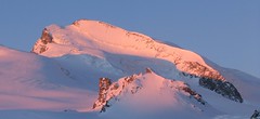
The Hospice du Grand-Saint-Bernard serves not only a spiritual role but also functions as a mountain hut at the Grand Saint Bernard Pass between Switzerland and Italy. It is operated in a similar way to other alpine huts. This hospice offers refuge to ski mountaineers following the Grand Lui variant of the Haute Route from Chamonix to Zermatt.
Tours starting from hut
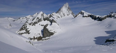
Ski tours around Hut Hospice du Grand-Saint-Bernard

- Country
- Switzerland
- Montains
- Walliser Alpen / Alpes valaisannes
- Open (winter)
- daily
- Beds
- 80
- Winterraum
- no
- Shortening of access (cableway, lift, taxi, snowcat...)
- Luggage transport
- no
- Card Pay
- yes
- Shower
- yes
- Wifi
- yes
- UTM / CH1903 x ("longitude" E/W)
- 579185
- UTM / CH1903 y ("latitude" N/S)
- 79743
- Map
- Martigny 282 S, Swisstopo 1:50000 1365 Gd-St-Bernard, Swisstopo 1:25000 1345 Orsières, Swisstopo 1:25000
- Guides
- Ski de randonnée Bas-Valais Die klassischen Skitouren (SAC, deutsch) Les classiques de randonnée à ski (SAC, francais) Walliser Alpen (Rother, deutsch) Haute Route (Rother, deutsch) Haute Route Chamonix-Zermatt (JM editions, french)
- find current conditions and experiences on the spot
- gipfelbuch.ch
- Phone (hut)
- +4127 787 12 36
- Phone (valley)
- -
- Cell phone
- -
- Mobile Signal
- yes
- Web
- gsbernard.com
- hospice@gsbernard.com
- Owner of hut
- -
- Reservation
- online
- Online reservation
- https://gsbernard.com/
- Avalanche danger
- www.slf.ch
- Weather
- Grand St Bernard Pass 2479 m / meteoblue.com Pointe du Drone 2950 m / mountain-forecast.com Mont Vélan 3770 m / mountain-forecast.com Meteoschweiz
- Snow report
- Val Ferret - La Fouly, bergfex.ch Val Ferret - La Fouly, snow-forecast.com Val Ferret - La Fouly, onthesnow.com
- Webcams
- Tunnel Gd St Bernard Pays St. Bernard
- Region
- Pays St. Bernard Wallis.ch
- Public traffic
- train SBB Bus - Postauto.ch
- Skiresort nearby
- Val Ferret - La Fouly Verbier
- Other links
- Swiss Tourism
hut Hospice du Grand-Saint-Bernard - Reviews
There are no reviews in this section yet. Click the Add Review button to add first review.
Video of ski tour
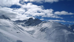
Best ski tours in mountains Walliser Alpen / Alpes valaisannes, Switzerland
-

Pigne d´Arolla 3790 m
Cabane des Dix Walliser Alpen / Alpes valaisannes Switzerland
- Length of ascent6 km
- ascent1000 m
- duration5-7,5 h
- Fitness difficulty ♦♦◊◊
- Technical difficulty ♦♦♦◊
Pigne d´Arolla is a very popular and easily accessible viewpoint. The ski tour to the summit leads from the three mountain huts - Cabane Dix, Cabane Vignettes and Cabane Chanrion. The route from Dix goes around the glacial seracs to the saddle Col de la Serpentine and the summit can be reached on skis. A worthwhile summit on the Haute Routes to Zermatt.

-
Strahlhorn 4190 m
Britannia Hütte Walliser Alpen / Alpes valaisannes Switzerland
- Length of ascent9,4 km
- ascent1250 m
- duration6-8 h
- Fitness difficulty ♦♦♦◊
- Technical difficulty ♦♦◊◊
Strahlhorn (Britannia Hütte, Walliser Alpen) is a classic glacier ski tour from Britannia Hütte. From the Adlerpass saddle, you usually go skiing to the top. To get off Saas Fee, take the Metro to the "window" at 3460 m to the Hohlaub Gletscher and start the ascent after a short ride.
-

Blanc de Moming - Dôme Circuit 3649 m
Cabane du Mountet Walliser Alpen / Alpes valaisannes Switzerland
- Length of ascent10 km
- ascent2035 m
- duration9-11 h
- Fitness difficulty ♦♦♦♦
- Technical difficulty ♦♦♦♦
Blanc de Moming - Dôme is a beautiful but also very demanding complex ski tour. First ascent from Cabane Mountet to La Forcle saddle and then not very easy descent and then ascent along the Glacier du Besso. At the end of the glacier there is an uncomfortable border between snow and rock. Climb a rocky slope. First along a flat ridge, which is increasingly exposed. It is recommended to belay in windy weather. At the beginning of the spectacular descent along the Glacier de Moming, pay attention to the gigantic cracks. The departure line (keep left) turns from the northern to the western slope. After reaching the valley there is an easy ascent along the Glacier de Zinal back to Cabane Mountet.
Best ski tours in Switzerland by skitour.guru
-
Vorderes Galmihorn 3507 m
Oberaarjochhütte Berner Alpen / Alpes bernoises Switzerland
- Length of ascent2,5 km
- ascent760 m
- duration4,5-6,5 h
- Fitness difficulty ♦♦◊◊
- Technical difficulty ♦♦♦◊
Vorderes Galmihorn je skvělý skialpový vrchol na závěr akce v centru Bernských Alp. Po výstupu na vrchol z chaty Oberaletschhütte přináší skvělou možnost sjezdu do údolí Goms, což je logisticky výhodné v případě startu lanovkou z Fiesch. Výstup vede po mírném ledovci Galmigletscher a dále po přehledném svahu posetém trhlinami. Při sjezdu dávejte pozor na trhlinu pod sedlem Bächlilicke. Na jaře vás v závěru túry nemine pochod do údolí s lyžemi na batohu. Nabízí se sjezd do Reckingenu nebo Münsteru.
-
Piz Muragl 3156 m
Muottas Muragl - Romantik Hotel Albula Alps Switzerland
- Length of ascent6 km
- ascent780 m
- duration4,5,5 h
- Fitness difficulty ♦♦◊◊
- Technical difficulty ♦♦◊◊
Piz Muragl je dokonalá vyhlídková hora. Výstup ulehčí zubačka na Muottas Muragl a příjemný sjezd dovede lyžaře na parkoviště u vláčku. Perfektní výhledy na velikány masivu Bernina i kaskádu jezer kolem St. Moritz. Technicky nenáročná túra.
-

Isentällispitz 2985 m
Davos Albula Alps Switzerland
- Length of ascent4 km
- ascent1050 m
- duration3-4,5 h
- Fitness difficulty ♦♦◊◊
- Technical difficulty ♦♦◊◊
Isentällispitz is another enjoyable ski tour starting in the Flüelatal valley. From the Tschuggen parking lot, ascend over wide slopes to the saddle, where the ski depot is located. From there, continue with crampons to the panoramic summit. The descent follows the ascent route.