
 Česky
Česky Deutsch


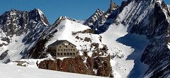


The Cabane des Vignettes is located at the crossroads of two haute routes to Zermatt. One leads from Chamonix and the other from Verbier. All ski tours to the Vignettes hut follow the glaciers. The easiest approach is from Arolla. In addition to going from hut to hut, you can ski from Vignettes to the peaks of L'Eveque, Mont Brulé and Pigne Arolla. Reservations have to be made on time.
Tours starting from hut
Ski tours around Hut Cabane des Vignettes

- Country
- Switzerland
- Montains
- Walliser Alpen / Alpes valaisannes
- Open (winter)
- mid March - end May
- Beds
- 120
- Winterraum
- yes, 12 beds
- Shortening of access (cableway, lift, taxi, snowcat...)
- no
- Luggage transport
- no
- Card Pay
- yes
- Shower
- no
- Wifi
- no
- UTM / CH1903 x ("longitude" E/W)
- 602870
- UTM / CH1903 y ("latitude" N/S)
- 93140
- GPX access to hut (waipoints, track)
- VignettesH_access_Arolla.gpx
- GPX access to hut (track only)
- Vignettes-Hut_all_access_TRK.gpx
- Map
- Arolla 283 S, Swisstopo 1:50000 Matterhorn 1347, Swisstopo 1:25000
- Guides
- Ski de randonnée Bas-Valais Die klassischen Skitouren (SAC, deutsch) Les classiques de randonnée à ski (SAC, francais) Walliser Alpen (Rother, deutsch)
- Phone (hut)
- +41 27 283 13 22
- Phone (valley)
- -
- Cell phone
- -
- Mobile Signal
- yes
- Web
- cabanedesvignettes.ch
- info@cabanedesvignettes.ch
- Owner of hut
- SAC Monte Rosa
- Cabane des Vignettes
- Reservation
- online former
- Online reservation
- alpsonline.org
- Avalanche danger
- www.slf.ch
- Weather
- SRF Meteo Meteoschweiz Cabane Vignettes. meteoblue.com Mont Collon, mountain-forecast.com Pigne Arolla, mountain-forecast.com L´Eveque, mountain-forecast.com Arolla, yr.no Arolla, snow-forecast.com
- Snow report
- Arolla, snow-forecast.com Arolla, bergfex.ch Arolla, onthesnow.com skiresort.info snow.myswitzerland.com/
- Webcams
- Evolene Arolla
- Region
- Val d´Hérens Wallis.ch
- Public traffic
- train SBB bus - Postauto.ch
- Skiresort nearby
- Arolla Verbier
- Other links
- Swiss Tourism
hut Cabane des Vignettes - Reviews
There are no reviews in this section yet. Click the Add Review button to add first review.
Best ski tours in mountains Walliser Alpen / Alpes valaisannes, Switzerland
-
Strahlhorn 4190 m
Britannia Hütte Walliser Alpen / Alpes valaisannes Switzerland
- Length of ascent9,4 km
- ascent1250 m
- duration6-8 h
- Fitness difficulty ♦♦♦◊
- Technical difficulty ♦♦◊◊
Strahlhorn (Britannia Hütte, Walliser Alpen) is a classic glacier ski tour from Britannia Hütte. From the Adlerpass saddle, you usually go skiing to the top. To get off Saas Fee, take the Metro to the "window" at 3460 m to the Hohlaub Gletscher and start the ascent after a short ride.

-

Tour du Ciel - day 2 3404 m
Schönbielhütte Walliser Alpen / Alpes valaisannes Switzerland
- Length of ascent5 km
- ascent1190 m
- duration5-7 h
- Fitness difficulty ♦♦♦◊
- Technical difficulty ♦♦♦◊
Tour du Ciel (known as the reverse direction of the Haute Route Impériale) begins with the first real stage from the Schönbiel Hut, featuring a descent along the edge of the moraine. This is followed by a long, steep climb over glacier seracs, ideally tackled in the early morning. The subsequent ascent over the Hohlwäng Glacier to the Col Durand (3404 m) is then straightforward. An alternative is to turn right before the pass and climb Mont Durand. From the pass, descend over the Glacier Durand, followed by a short climb to the Cabane Mountet.
-

Bishorn 4153 m
Cabane Tracuit Walliser Alpen / Alpes valaisannes Switzerland
- Length of ascent4,5 km
- ascent950 m
- duration5-6,5 h
- Fitness difficulty ♦♦♦◊
- Technical difficulty ♦♦◊◊
Bishorn seems to be a relatively light 4000, but looks are deceptive. If you include the approach to Cabane Tracuit from Zinal in the ascent, it is quite a long ski tour. From the hut the ascent line leads slightly up the glacier Turtmanngletscher. Directly below the peak on the plateau you have to swap skis for crampons and comfortably climb to the panoramic summit - one of the best in all of Valais. Driving down the northern slope is usually a fantastic enjoyment, the risk of glacier cracks is minimal.
Best ski tours in Switzerland by skitour.guru
-

Monte Rosso 3088 m
Fornohütte - Capanna del Forno Bernina Alps Switzerland
- Length of ascent4 km
- ascent840 m
- duration4-5,5 h
- Fitness difficulty ♦♦◊◊
- Technical difficulty ♦♦♦◊
Skvělým skialpovým vrcholem uprostřed oblasti je Monte Rosso. Výhodou okruhu je maximalistický krajinářský zážitek. Po výstupu do dvou sedel se otevřou vždy nové výhledy. Od chaty míříme nejprve do sedla Sella del Forno. Koukáme na Berninu a dolů na skiresort Valmalenco. Krásným kotlem po krátkém sjezdu traverujeme a míříme nahoru do druhého sedla – Passo di Val Bona. Po strmějším svahu do místa na skalním hřebenu, kde je skidepot. Odtud v mačkách na vrchol. Na lyžích parádní sjezd jihozápadním svahem na ledovec Forno a zpět nahoru k chatě.
-

Jungfrau 4158 m
Konkordiahütte Berner Alpen / Alpes bernoises Switzerland
- Length of ascent10 km
- ascent1510 m
- duration6,5-9 h
- Fitness difficulty ♦♦♦◊
- Technical difficulty ♦♦♦◊
Skialpová túra na Jungfrau z chaty Konkordia začíná velmi dlouhým nástupem po ledovci Jungfraufirn. Následuje prudký výstup na hřeben a dále do sedla Rottalsattel přes nepříjemnou thlinu. Skidepot a na mčkách a s cepínem po plochém hřebenu na vrchol. Alternativní sjezd přes sedlo Louwitor na ledovec Aletschfirn a po něm na chatu Konkordia. Možné je po dosažení vrcholu pokračovat na nádraží Jungfraujoch nebo nocovat na Mönchsjochhütte.
-

Isenfürggli 2765 m
Davos Albula Alps Switzerland
- Length of ascent3 km
- ascent845 m
- duration2,5-3,5 h
- Fitness difficulty ♦♦◊◊
- Technical difficulty ♦♦◊◊
The ascent to the Isenfürggli saddle is a worthwhile addition after successful descents from Pischahorn or Isentällispitz. Especially in firn conditions or fresh powder, it is a rewarding destination. From the saddle, there is a beautiful view of the Silvretta range, with the striking Piz Linard as its centerpiece.