
 Česky
Česky Deutsch


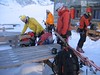


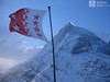
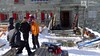


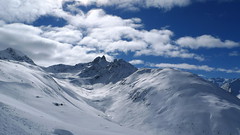
The classic mountain hut Schönbielhütte rises on the terrace above the Zmutt glacier. Nice view of the north face of the Matterhorn and the Monte Rosa massif on the horizon. Ski tours to Tete Blanche and Tete Valpelline start from the hut. The demanding crossing of the Haute Route Imperiale, french Tour du Ciel named, begins at Schönbielhütte. As part of the stage to Cabane Mountet you can turn to Mont Durand. The easiest access to the Schönbielhütte is from the Schwarzsee cable car station, you can also start from Zermatt or from the Furi cable car intermediate station.
Tours starting from hut
Ski tours around Hut Schönbielhütte
-

Tour du Ciel - day 1 2695 m
Schönbielhütte Walliser Alpen / Alpes valaisannes Switzerland
- Length of ascent6,5 km
- ascent650 m
- duration4-5,5 h
- Fitness difficulty ♦♦♦◊
- Technical difficulty ♦♦◊◊
The high-altitude crossing Tour du Ciel begins in Zermatt and ends in the Val d’Anniviers, running from north to south. The first stage starts in Zermatt; for better acclimatization, it is recommended to spend the night at the Schönbiel Hut – possibly combined with an ascent of the Tête Blanche. The easiest version of the route begins at the upper station of the Schwarzsee cable car.

-

Tour du Ciel - day 2 3404 m
Schönbielhütte Walliser Alpen / Alpes valaisannes Switzerland
- Length of ascent5 km
- ascent1190 m
- duration5-7 h
- Fitness difficulty ♦♦♦◊
- Technical difficulty ♦♦♦◊
Tour du Ciel (known as the reverse direction of the Haute Route Impériale) begins with the first real stage from the Schönbiel Hut, featuring a descent along the edge of the moraine. This is followed by a long, steep climb over glacier seracs, ideally tackled in the early morning. The subsequent ascent over the Hohlwäng Glacier to the Col Durand (3404 m) is then straightforward. An alternative is to turn right before the pass and climb Mont Durand. From the pass, descend over the Glacier Durand, followed by a short climb to the Cabane Mountet.
-
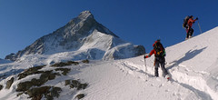
Mont Durand / Arbenhorn 3713 m
Schönbielhütte Walliser Alpen / Alpes valaisannes Switzerland
- Length of ascent5,5 km
- ascent1630 m
- duration7-10 h
- Fitness difficulty ♦♦♦◊
- Technical difficulty ♦♦♦◊
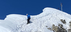
Mont Durand, also known as the Arbenhorn, is a great panoramic point. Matterhorn on one side, Dent Blanche on the other. From the Schönbielhütte an early morning descent on the edge of the moraine to the plateau Hohle Bielen. On a sunny day it is necessary to overcome the steep slope below the Schönbielhorn in good time. More precisely above the edge of the Hohwäng glacier up to an altitude of 3200 m. Continue with a slight ascent along this glacier in a northeastern direction above the level of the Col Durand saddle. Until the height to which it is possible to climb on skis and with crampons and ice ax on a relatively exposed slope to the summit. If you follow the ascent route, watch out for avalanches and snow slides that come from the Schönbielhorn in the afternoon sun.
- Country
- Switzerland
- Montains
- Walliser Alpen / Alpes valaisannes
- Open (winter)
- mid March - mid May
- Beds
- 70
- Winterraum
- yes, 12 beds
- Shortening of access (cableway, lift, taxi, snowcat...)
- yes, from Zermatt to Furi or Schwarzsee
- Luggage transport
- no
- Card Pay
- yes
- Shower
- no
- Wifi
- no
- UTM / CH1903 x ("longitude" E/W)
- 614746
- UTM / CH1903 y ("latitude" N/S)
- 94503
- GPX access to hut (waipoints, track)
- Schönbielhütte_all_access.gpx
- GPX access to hut (track only)
- Schoenbiel-Hut_all_access_TRK.gpx
- Map
- Arolla 283 S, Swisstopo 1:50000 Matterhorn 1347, Swisstopo 1:25000 Zermatt 1348, Swisstopo 1:25000
- Guides
- Ski de randonnée Bas-Valais Die klassischen Skitouren (SAC, deutsch) Les classiques de randonnée à ski (SAC, francais) Walliser Alpen (Rother, deutsch)
- Phone (hut)
- +41 27 967 13 54
- Phone (valley)
- -
- Cell phone
- +41 (0)79 639 41 28
- Mobile Signal
- yes
- Web
- schoenbielhuette.ch
- bielti.zermatt@gmx.ch
- Owner of hut
- SAC Monte Rosa
- Schönbielhütte
- Reservation
- online former
- Online reservation
- alpsonline.org
- Start Point
- Zermatt - ZenStecken
- UTM / CH1903 x ("longitude" E/W)
- 622740
- UTM / CH1903 y ("latitude" N/S)
- 94493
- Altitude
- 1614 m
- Ascent (height difference)
- 1080 m
- Time of Access
- 4-5 h
- Shortening lift
- no
- Start Point
- Schwarzsee - cable car station
- UTM / CH1903 x ("longitude" E/W)
- 620948
- UTM / CH1903 y ("latitude" N/S)
- 93430
- Altitude
- 3726 m
- Ascent (height difference)
- 700 m
- Time of Access
- 3-4 h
- Shortening lift
- yes, by cable car Zermatt - Furi - Schwarzsee
- Avalanche danger
- www.slf.ch
- Weather
- SRF Meteo Meteoschweiz Zermatt, snow-forecast.com Klein Matterhorn, meteoblue.com Wandfluehorn 3589 / mountain-forecast.com Tete Blanche 3750m / mountain-forecast.com Tete Valpelline 3798m / mountain-forecast.com Mont Durand, mountain-forecast.com Schweiz TV - animation Bergwetter / alpenverein.at Zermatt / kachelmannwetter.com Gornergrat 3130m / meteocentrale.ch
- Snow report
- Zermatt, snow-forecast.com Zermatt, bergfex.ch Zermatt, onthesnow.com Zermatt, skiresort.info snow.myswitzerland.com/
- Webcams
- Zermatt - Schwarzsee Zermatt - Bahnhof Zermatt - 29 webcams
- Region
- Zermatt Wallis.ch
- Public traffic
- train SBB bus - Postauto.ch
- Skiresort nearby
- Zermatt, matterhornparadise.ch
- Other links
- Swiss Tourism
hut Schönbielhütte - Reviews
There are no reviews in this section yet. Click the Add Review button to add first review.
Best ski tours in mountains Walliser Alpen / Alpes valaisannes, Switzerland
-

Bishorn 4153 m
Cabane Tracuit Walliser Alpen / Alpes valaisannes Switzerland
- Length of ascent4,5 km
- ascent950 m
- duration5-6,5 h
- Fitness difficulty ♦♦♦◊
- Technical difficulty ♦♦◊◊
Bishorn seems to be a relatively light 4000, but looks are deceptive. If you include the approach to Cabane Tracuit from Zinal in the ascent, it is quite a long ski tour. From the hut the ascent line leads slightly up the glacier Turtmanngletscher. Directly below the peak on the plateau you have to swap skis for crampons and comfortably climb to the panoramic summit - one of the best in all of Valais. Driving down the northern slope is usually a fantastic enjoyment, the risk of glacier cracks is minimal.
-

Tour du Ciel - day 5 3030 m
Turtmannhütte / Cabane Tourtemagne Walliser Alpen / Alpes valaisannes Switzerland
- Length of ascent5,5 km
- ascent1110 m
- duration5-7 h
- Fitness difficulty ♦♦◊◊
- Technical difficulty ♦♦◊◊
A relatively easy ascent, though steep in places, from Lake Turtmannsee, which is reached by descending from the Turtmannhütte. From the summit ridge, there's a long descent to the Hotel Weisshorn, followed by forest trails leading down to the village of St. Luc - Chandolin in the Val d'Anniviers.
-

Alphubel 4206 m
Britannia Hütte Walliser Alpen / Alpes valaisannes Switzerland
- Length of ascent10 km
- ascent1450 m
- duration7-10 h
- Fitness difficulty ♦♦♦◊
- Technical difficulty ♦♦♦◊
ALPHUBEL (Britannia Hütte, Walliser Alpen) is seemingly lighter 4000vka, but over are dangerous glacial cracks. Ski alpinists can also go from the Saas Fee ski area, most not far from the cable car station Langfluh .
Best ski tours in Switzerland by skitour.guru
-
Pizzo Lucendro 2963 m
Rotondohütte Urner Alps Switzerland
- Length of ascent5,5 km
- ascent1090 m
- duration4-6 h
- Fitness difficulty ♦♦◊◊
- Technical difficulty ♦♦♦◊
Pizzo Lucendro je výrazný vrchol nad Gotthardpassem a také prvotřídní rozhledna. Na túru lze vyrazit z údolního Realpu, snazší je start z chaty Rotondohütte. Po sjezdu nad úroveň salaší nastává dlouhý výstup členitým terénem, který nabírá na strmosti. Těsně pod skalním sedlem je v úzkém koridoru zvládání otočky nutností. Za sedlem následuje poměrně snadný výstup do sedla, k místu, kde bývá depo lyží. Při výstupu po hřebeni k vrcholovému kříži pozor na převěje a místy exponovaný terén. Při sjezdu za jarního firnu se vyplatí počkat v sedle, než slunce změkčí stinný svah pro velkolepý odpolední sjezd západním svahem. Z nejnižšího bodu návrat na chatu nebo sjezd až do Realpu.
-
Piz Muragl 3156 m
Muottas Muragl - Romantik Hotel Albula Alps Switzerland
- Length of ascent6 km
- ascent780 m
- duration4,5,5 h
- Fitness difficulty ♦♦◊◊
- Technical difficulty ♦♦◊◊
Piz Muragl je dokonalá vyhlídková hora. Výstup ulehčí zubačka na Muottas Muragl a příjemný sjezd dovede lyžaře na parkoviště u vláčku. Perfektní výhledy na velikány masivu Bernina i kaskádu jezer kolem St. Moritz. Technicky nenáročná túra.
-

Piz Bernina 4048 m
Chamanna Boval / Bovalhütte Bernina Alps Switzerland
- Length of ascent7,5 km
- ascent1695 m
- duration8-10,5 h
- Fitness difficulty ♦♦♦♦
- Technical difficulty ♦♦♦♦
Piz Bernina is the only 4000m peak in the Eastern Alps. The greatest danger are the huge and numerous crevasses on the Morteratsch Glacier and the ridge to the summit. Piz Bernina sets off from Chamanna Boval or Rifugio Marco e Rosa on the plateau below the summit. Bernina is a demanding alpine challenge.