
 Česky
Česky Deutsch


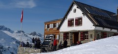


The Chalet Turtmannhütte, french Cabane Tourtemagne, is in a relatively secluded location. Magnificent backdrop of the nearby rock walls and glaciers. The mountain hut is famous for its home cooking, especially excellent soups. The Turtmannhütte is the last hut on the Haute Route Imperale / Tour du Ciel. Üssers Barrhorn is an attractive ski tour. The last tour of the crossing is the ascent to the l´Omen Roso and a spectacular descent to the village of St-Luc. The best way to the hut is by cable car from the Anniviers valley. From the St-Luc ski resort take the cable car at 3000m to Bella Tola and from there via Borterpass and Meidtälli to the hut.
Tours starting from hut
Ski tours around Hut Turtmannhütte / Cabane Tourtemagne
-
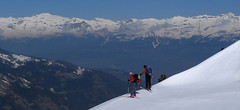
L´Omen Roso 3030 m
Turtmannhütte / Cabane Tourtemagne Walliser Alpen / Alpes valaisannes Switzerland
- Length of ascent6 km
- ascent1300 m
- duration5,5-7 h
- Fitness difficulty ♦♦◊◊
- Technical difficulty ♦♦◊◊
L´Omen Roso is a relatively easy to reach 3000 peak on the edge of the Valais Alps. The ascent begins either in the Turtmannhütte or in the St. Luc ski area in Val d´Anniviers. The usual is this ski tour last stage of the Haute Route Tour du Ciel. From the hut up to the crest and the descent on the other side, into the valley. A technically undemanding ski tour. On the upper ridge, watch out for the cornices.

-

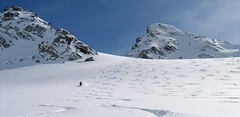
Tour du Ciel - day 5 3030 m
Turtmannhütte / Cabane Tourtemagne Walliser Alpen / Alpes valaisannes Switzerland
- Length of ascent5,5 km
- ascent1110 m
- duration5-7 h
- Fitness difficulty ♦♦◊◊
- Technical difficulty ♦♦◊◊
A relatively easy ascent, though steep in places, from Lake Turtmannsee, which is reached by descending from the Turtmannhütte. From the summit ridge, there's a long descent to the Hotel Weisshorn, followed by forest trails leading down to the village of St. Luc - Chandolin in the Val d'Anniviers.
- Country
- Switzerland
- Montains
- Walliser Alpen / Alpes valaisannes
- Open (winter)
- end March - mid May
- Beds
- 74
- Winterraum
- yes, 14 beds
- Shortening of access (cableway, lift, taxi, snowcat...)
- no
- Luggage transport
- no
- Card Pay
- no
- Shower
- no
- Wifi
- no
- UTM / CH1903 x ("longitude" E/W)
- 620160
- UTM / CH1903 y ("latitude" N/S)
- 112100
- GPX access to hut (waipoints, track)
- TurtmannHut_access_skitour.gpx
- GPX access to hut (track only)
- TurtmannHte_access_StLuc_BellaTolaTRK.gpx
- Map
- Visp 274 S, Swisstopo 1:50000 Montana 273 S, Swisstopo 1:50000 Evolene 1287, Swisstopo 1:25000 Vissoie 1307, Swisstopo 1:25000 St. Niklaus 1308, Swisstopo 1:25000 Raron 1288, Swisstopo 1:25000
- Guides
- Ski de randonnée Bas-Valais Die klassischen Skitouren (SAC, deutsch) Les classiques de randonnée à ski (SAC, francais) Walliser Alpen (Rother, deutsch)
- find current conditions and experiences on the spot
- gipfelbuch.ch
- Phone (hut)
- +41 27 932 14 55
- Phone (valley)
- +41 27 934 34 84
- Cell phone
- -
- Mobile Signal
- no
- Web
- turtmannhuette.ch
- info@turtmannhuette.ch
- Owner of hut
- CAS Prevotoise
- SAC Turtmannhütte
- Reservation
- e-mail, phone
- Start Point
- St-Luc, cable car station Bella Tolla
- UTM / CH1903 x ("longitude" E/W)
- 616662
- UTM / CH1903 y ("latitude" N/S)
- 120813
- Altitude
- 3026 m
- Ascent (height difference)
- 950 m
- Time of Access
- 4-5 h
- Shortening lift
- yes, from St-Luc to Bella Tola
- Avalanche danger
- www.slf.ch
- Weather
- SRF Meteo Meteoschweiz St.Luc - Chandolin, snow-forecast.com Brunegghorn /mountain-forecast.com Omen Roso / mountain-forecast.com Les Diablons 3609 m / mountain-forecast.com Bishorn 4153 / mountain-forecast.com Üssers Barrhorn 3610, mountain-forecast.com Schweiz TV - animation Bergwetter / alpenverein.at St.Luc - Chandolin / meteoblue.com Turtmanntal / yr.no
- Snow report
- St.Luc - Chandolin, snow-forecast.com St.Luc - Chandolin, bergfex.ch St.Luc - Chandolin, onthesnow.com St.Luc - Chandolin, skiresort.info snow.myswitzerland.com/
- Webcams
- St. Luc - Chandolin, 5 webcams Zinal webcams
- Region
- Turtmanntal Tourismus Wallis.ch Val d´Anniviers
- Public traffic
- train SBB bus - Postauto.ch
- Skiresort nearby
- St. Luc - Chandolin
- Other links
- Swiss Tourism
hut Turtmannhütte / Cabane Tourtemagne - Reviews
There are no reviews in this section yet. Click the Add Review button to add first review.
Best ski tours in mountains Walliser Alpen / Alpes valaisannes, Switzerland
-

Pigne d´Arolla 3790 m
Cabane des Dix Walliser Alpen / Alpes valaisannes Switzerland
- Length of ascent6 km
- ascent1000 m
- duration5-7,5 h
- Fitness difficulty ♦♦◊◊
- Technical difficulty ♦♦♦◊
Pigne d´Arolla is a very popular and easily accessible viewpoint. The ski tour to the summit leads from the three mountain huts - Cabane Dix, Cabane Vignettes and Cabane Chanrion. The route from Dix goes around the glacial seracs to the saddle Col de la Serpentine and the summit can be reached on skis. A worthwhile summit on the Haute Routes to Zermatt.
-

Tour du Ciel - day 4 4153 m
Cabane Tracuit Walliser Alpen / Alpes valaisannes Switzerland
- Length of ascent6 km
- ascent1150 m
- duration5,5-7,5 h
- Fitness difficulty ♦♦♦◊
- Technical difficulty ♦♦♦◊
The stage begins at the Cabane Tracuit with an ascent of the 4,000-meter peak Bishorn, which is considered relatively easy. After skiing back down to the Tracuit hut, the route continues with a descent over the Turtmanngletscher glacier. A subsequent climb over the Brunegggletscher glacier leads into a rocky corridor, which marks the beginning of the descent to the Turtmannhütte.
-

Alphubel 4206 m
Britannia Hütte Walliser Alpen / Alpes valaisannes Switzerland
- Length of ascent10 km
- ascent1450 m
- duration7-10 h
- Fitness difficulty ♦♦♦◊
- Technical difficulty ♦♦♦◊
ALPHUBEL (Britannia Hütte, Walliser Alpen) is seemingly lighter 4000vka, but over are dangerous glacial cracks. Ski alpinists can also go from the Saas Fee ski area, most not far from the cable car station Langfluh .
Best ski tours in Switzerland by skitour.guru
-

Piz d´Err 3378 m
Chamanna Jenatsch / Jenatschhütte Albula Alps Switzerland
- Length of ascent km
- ascent m
- duration h
- Fitness difficulty ♦♦◊◊
- Technical difficulty ♦♦◊◊
Piz d´Err is a popular ski tour to the panoramic summit. The technically undemanding ski tour begins in Chamanna Jenatsch. The only steep section is climbing on the summit. A first class experience is under stable conditions the descent to the opposite side, western slopes to Surselva, more precisely to the village Sur, a total of 1,800 m.
-
Flüela Wisshorn 3085 m
Davos Albula Alps Switzerland
- Length of ascent6,5 km
- ascent1360 m
- duration5,5-7 h
- Fitness difficulty ♦♦◊◊
- Technical difficulty ♦♦♦◊
Flüela Wisshorn is the most interesting ski tour around Davos. It is offered to do an interesting round with two great downhills. The north slope to the Jöriseen lakes promises powder, while the south slopes to the Flüelatal valley promise firn. The ascent is not very demanding, at the end to the summit without skis with the help of crampons, then down to Jöriseen and noc once in the nameless saddle. Finally departure to the Flüelatal. Attention, in 2019 there was a landslide of stones in the area of the ascent route, which therefore changes the ascent route.
-

Gross Wannenhorn 3905 m
Finsteraarhornhütte Berner Alpen / Alpes bernoises Switzerland
- Length of ascent6,5 km
- ascent1310 m
- duration5,5-7,5 h
- Fitness difficulty ♦♦♦◊
- Technical difficulty ♦♦♦◊
The top of the Gross Wannenhorn is a first-class lookout tower on the largest alpine glacier, the Aletsch glacier and the many 4,000-meter peaks in the Bernese Alps. After a short descent from the Finsteraarhorn Hut over the glacier Fieschergletscher at the foot of the Wannenhorn. During the ascent along a wide slope, watch out for numerous and large crevasses. Finally, the ascent line turns westwards upwards. When driving downhill, copy the exit route and pay attention to crevasses again.