
 Česky
Česky Deutsch


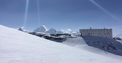


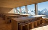
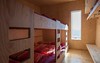

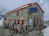

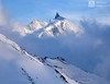
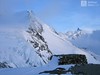


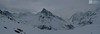


Cabane Tracuit was converted to a brand new high-tech hut in 2013. Tracuit hut is located on the Haute Route Imperiale (french Tour du Ciel). Starting point for the climb to 4000 Bishorn. It is possible to go to the Turtmannhütte, in good conditions you can do this above the Üssers Barrhorn. Zinal's access is very long. In order to master the route from Cabane Mountet to Blanc Moming, is excellent physical condition required.
Tours starting from hut
Ski tours around Hut Cabane Tracuit
-

Tour du Ciel - day 4 4153 m
Cabane Tracuit Walliser Alpen / Alpes valaisannes Switzerland
- Length of ascent6 km
- ascent1150 m
- duration5,5-7,5 h
- Fitness difficulty ♦♦♦◊
- Technical difficulty ♦♦♦◊
The stage begins at the Cabane Tracuit with an ascent of the 4,000-meter peak Bishorn, which is considered relatively easy. After skiing back down to the Tracuit hut, the route continues with a descent over the Turtmanngletscher glacier. A subsequent climb over the Brunegggletscher glacier leads into a rocky corridor, which marks the beginning of the descent to the Turtmannhütte.

-

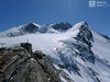
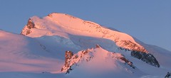
Bishorn 4153 m
Cabane Tracuit Walliser Alpen / Alpes valaisannes Switzerland
- Length of ascent4,5 km
- ascent950 m
- duration5-6,5 h
- Fitness difficulty ♦♦♦◊
- Technical difficulty ♦♦◊◊
Bishorn seems to be a relatively light 4000, but looks are deceptive. If you include the approach to Cabane Tracuit from Zinal in the ascent, it is quite a long ski tour. From the hut the ascent line leads slightly up the glacier Turtmanngletscher. Directly below the peak on the plateau you have to swap skis for crampons and comfortably climb to the panoramic summit - one of the best in all of Valais. Driving down the northern slope is usually a fantastic enjoyment, the risk of glacier cracks is minimal.
- Country
- Switzerland
- Montains
- Walliser Alpen / Alpes valaisannes
- Open (winter)
- mid March - mid May
- Beds
- 115
- Winterraum
- yes, 30 beds
- Shortening of access (cableway, lift, taxi, snowcat...)
- no
- Luggage transport
- no
- Card Pay
- no
- Shower
- no
- Wifi
- no
- UTM / CH1903 x ("longitude" E/W)
- 618620
- UTM / CH1903 y ("latitude" N/S)
- 108770
- GPX access to hut (waipoints, track)
- Tracuit-Hut_access_Zinal.gpx
- GPX access to hut (track only)
- Tracuit-Hut_access_Zinal_TRK.gpx
- Map
- Arolla 283 S, Swisstopo 1:50000 Montana 273 S, Swisstopo 1:50000 Evolene 1327, Swisstopo 1:25000 Vissoie 1307, Swisstopo 1:25000 St. Niklaus 1308, Swisstopo 1:25000
- Guides
- Ski de randonnée Bas-Valais Die klassischen Skitouren (SAC, deutsch) Les classiques de randonnée à ski (SAC, francais) Walliser Alpen (Rother, deutsch)
- find current conditions and experiences on the spot
- gipfelbuch.ch
- Phone (hut)
- +41 27 475 15 00
- Phone (valley)
- -
- Cell phone
- -
- Mobile Signal
- no
- Web
- tracuit.ch
- cabane@tracuit.ch
- Owner of hut
- CAS Chaussy
- Cabane Tracuit
- Reservation
- online former
- Online reservation
- tracuit.ch
- Start Point
- Zinal
- UTM / CH1903 x ("longitude" E/W)
- 614392
- UTM / CH1903 y ("latitude" N/S)
- 109620
- Altitude
- 1670 m
- Ascent (height difference)
- 1595 m
- Time of Access
- 6,5-7,5 h
- Shortening lift
- no
- Avalanche danger
- www.slf.ch
- Weather
- SRF Meteo Meteoschweiz Zinal, snow-forecast.com Cabane Tracuit, meteoblue.com Blanc Moming 3663 / mountain-forecast.com Les Diablons 3609 m / mountain-forecast.com Bishorn 4153 / mountain-forecast.com Üssers Barrhorn 3610, mountain-forecast.com Schweiz TV - animation Bergwetter / alpenverein.at Zinal, meteoblue.com
- Snow report
- Zinal, snow-forecast.com Zinal, bergfex.ch Zinal, onthesnow.com Zinal, skiresort.info snow.myswitzerland.com/
- Webcams
- Cabane Tracuit Zinal webcams
- Region
- Val d´Anniviers Wallis.ch
- Public traffic
- train SBB bus - Postauto.ch
- Skiresort nearby
- Grimentz-Zinal
- Other links
- Swiss Tourism
hut Cabane Tracuit - Reviews
There are no reviews in this section yet. Click the Add Review button to add first review.
Best ski tours in mountains Walliser Alpen / Alpes valaisannes, Switzerland
-

Blanc de Moming - Dôme Circuit 3649 m
Cabane du Mountet Walliser Alpen / Alpes valaisannes Switzerland
- Length of ascent10 km
- ascent2035 m
- duration9-11 h
- Fitness difficulty ♦♦♦♦
- Technical difficulty ♦♦♦♦
Blanc de Moming - Dôme is a beautiful but also very demanding complex ski tour. First ascent from Cabane Mountet to La Forcle saddle and then not very easy descent and then ascent along the Glacier du Besso. At the end of the glacier there is an uncomfortable border between snow and rock. Climb a rocky slope. First along a flat ridge, which is increasingly exposed. It is recommended to belay in windy weather. At the beginning of the spectacular descent along the Glacier de Moming, pay attention to the gigantic cracks. The departure line (keep left) turns from the northern to the western slope. After reaching the valley there is an easy ascent along the Glacier de Zinal back to Cabane Mountet.
-
Strahlhorn 4190 m
Britannia Hütte Walliser Alpen / Alpes valaisannes Switzerland
- Length of ascent9,4 km
- ascent1250 m
- duration6-8 h
- Fitness difficulty ♦♦♦◊
- Technical difficulty ♦♦◊◊
Strahlhorn (Britannia Hütte, Walliser Alpen) is a classic glacier ski tour from Britannia Hütte. From the Adlerpass saddle, you usually go skiing to the top. To get off Saas Fee, take the Metro to the "window" at 3460 m to the Hohlaub Gletscher and start the ascent after a short ride.
-

Breithorn - Zermatt 4164 m
Monte Rosa Hütte Walliser Alpen / Alpes valaisannes Switzerland
- Length of ascent3 km
- ascent440 m
- duration3-4 h
- Fitness difficulty ♦♦♦◊
- Technical difficulty ♦♦♦◊
Breithorn can be rated as the lightest 4000 in the Alps. In any case, thanks to the support of the Klein Matterhorn cable car, which transports ski mountaineers up to 3880 m. From the cable car station (beautiful viewpoint) to the glacier plain below the summit, which can be often reached on skis. In good conditions, it is worthwhile to continue to the Schwarztor saddle and drive descent back to Zermatt. The second variant of the freeride is the descent from the Unterer Theodulgletscher. This descent is simply great up to Seehöre 2400.
Best ski tours in Switzerland by skitour.guru
-

Isenfürggli 2765 m
Davos Albula Alps Switzerland
- Length of ascent3 km
- ascent845 m
- duration2,5-3,5 h
- Fitness difficulty ♦♦◊◊
- Technical difficulty ♦♦◊◊
The ascent to the Isenfürggli saddle is a worthwhile addition after successful descents from Pischahorn or Isentällispitz. Especially in firn conditions or fresh powder, it is a rewarding destination. From the saddle, there is a beautiful view of the Silvretta range, with the striking Piz Linard as its centerpiece.
-

Tödi 3614 m
Fridolinshütte Glarus Alps Switzerland
- Length of ascent6 km
- ascent1495 m
- duration7-10 h
- Fitness difficulty ♦♦♦◊
- Technical difficulty ♦♦♦♦
In the Middle Ages, Tödi was considered the highest mountain in the world. Today it is an attractive destination for ski mountaineers, but it is not easy to hit good weather. The ascent is made difficult by a glacier littered with fractures and cracks. Starts from the Fridolins hut over the moraine and descends briefly to the Bifertenfirn glacier. The hardest part is to overcome the first two drops, then the climb up is relatively easy. Depending on the conditions on skis or with crampons to the summit. Provides information about the current conditions on the glacier in the Fridolinshütte.
-

Jungfrau 4158 m
Konkordiahütte Berner Alpen / Alpes bernoises Switzerland
- Length of ascent10 km
- ascent1510 m
- duration6,5-9 h
- Fitness difficulty ♦♦♦◊
- Technical difficulty ♦♦♦◊
Skialpová túra na Jungfrau z chaty Konkordia začíná velmi dlouhým nástupem po ledovci Jungfraufirn. Následuje prudký výstup na hřeben a dále do sedla Rottalsattel přes nepříjemnou thlinu. Skidepot a na mčkách a s cepínem po plochém hřebenu na vrchol. Alternativní sjezd přes sedlo Louwitor na ledovec Aletschfirn a po něm na chatu Konkordia. Možné je po dosažení vrcholu pokračovat na nádraží Jungfraujoch nebo nocovat na Mönchsjochhütte.