
 Česky
Česky Deutsch


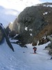


Cabane Valsorey is a traditional mountain hut on the classic haute route Chamonix - Zermatt. The hut can be reached from Bourg St-Pierre or Cabane Vélan via a ski tour over Mont Vélan. The climb to the Grand Combin is very challenging. The famous ski tour is the haute route over the Plateau Couloir to the hut Cabane Chanrion.
Tours starting from hut
Ski tours around Hut Cabane Valsorey

- Country
- Switzerland
- Montains
- Walliser Alpen / Alpes valaisannes
- Open (winter)
- mid March - mid May
- Beds
- 60
- Winterraum
- yes, 30 beds
- Shortening of access (cableway, lift, taxi, snowcat...)
- no
- Luggage transport
- no
- Shower
- no
- Wifi
- no
- UTM / CH1903 x ("longitude" E/W)
- 587060
- UTM / CH1903 y ("latitude" N/S)
- 86544
- GPX access to hut (waipoints, track)
- Valsorey-Hut_access_BourgStPierre_skitour.gpx
- GPX access to hut (track only)
- Valsorey-Hut_access_Bourg-St-Pierre_TRK.gpx
- Map
- Arolla 283 S, Swisstopo 1:50000 Chanrion 1346, Swisstopo 1:25000 Mont Vélan 1366, Swisstopo 1:25000 Orsiéres 1345, Swisstopo 1:25000
- Guides
- Ski de randonnée Bas-Valais Die klassischen Skitouren (SAC, deutsch) Les classiques de randonnée à ski (SAC, francais) Walliser Alpen (Rother, deutsch)
- Phone (hut)
- 0041(0)27 7871122
- Phone (valley)
- 0041(0) 78 625 52 42
- Cell phone
- -
- Web
- valsorey.ch
- info@valsorey.ch
- Owner of hut
- SAC Sektion La Chaux-de-Fonds
- Cabane Valsorey
- Reservation
- phone, e-mail
- Start Point
- Bourg St. Pierre
- UTM / CH1903 x ("longitude" E/W)
- 582257
- UTM / CH1903 y ("latitude" N/S)
- 88683
- Altitude
- 1655 m
- Ascent (height difference)
- 1400 m
- Time of Access
- 5-6,5 h
- Shortening lift
- no
- Avalanche danger
- www.slf.ch
- Weather
- SRF Meteo Meteoschweiz Combin Meitin, mountain-forecast.com Cab. Valsorey, Meteoblue.com Plateau Couloir, Meteoblue.com Gr. Combin Valsorey, mountain-forecast.com Gr. Tete de By, mountain-forecast.com Bourg St.-Pierre, yr.no Bourg St.-Pierre, meteoblue.com
- Snow report
- bergfex.ch, Liddes - Vichères
- Webcams
- Grand St. Bernard Tunnel
- Region
- Bourg-Saint-Pierre Wallis.ch Pays du Saint-Bernard
- Public traffic
- train SBB Bus - Postauto.ch
- Skiresort nearby
- Liddes - Vichères
- Other links
- Swiss Tourism
hut Cabane Valsorey - Reviews
There are no reviews in this section yet. Click the Add Review button to add first review.
Best ski tours in mountains Walliser Alpen / Alpes valaisannes, Switzerland
-

Fenetre Ferret - H.R. Grande Lui, Day 3 2698 m
La Fouly Walliser Alpen / Alpes valaisannes Switzerland
- Length of ascent11 km
- ascent1330 m
- duration5-7 h
- Fitness difficulty ♦♦♦◊
- Technical difficulty ♦♦◊◊
The Haute Route Grande Lui variant from Chamonix to Zermatt, also known as the "Haute Route Pure", leads from La Fouly to the Grand Saint Bernard Pass. Overnight accommodation is provided in the hospice of the same name, under conditions similar to those in a mountain hut. The traverse of the slope below the Ferret lakes is particularly prone to avalanches.

-

Tour du Ciel - day 5 3030 m
Turtmannhütte / Cabane Tourtemagne Walliser Alpen / Alpes valaisannes Switzerland
- Length of ascent5,5 km
- ascent1110 m
- duration5-7 h
- Fitness difficulty ♦♦◊◊
- Technical difficulty ♦♦◊◊
A relatively easy ascent, though steep in places, from Lake Turtmannsee, which is reached by descending from the Turtmannhütte. From the summit ridge, there's a long descent to the Hotel Weisshorn, followed by forest trails leading down to the village of St. Luc - Chandolin in the Val d'Anniviers.
-

Pigne d´Arolla 3790 m
Cabane des Dix Walliser Alpen / Alpes valaisannes Switzerland
- Length of ascent6 km
- ascent1000 m
- duration5-7,5 h
- Fitness difficulty ♦♦◊◊
- Technical difficulty ♦♦♦◊
Pigne d´Arolla is a very popular and easily accessible viewpoint. The ski tour to the summit leads from the three mountain huts - Cabane Dix, Cabane Vignettes and Cabane Chanrion. The route from Dix goes around the glacial seracs to the saddle Col de la Serpentine and the summit can be reached on skis. A worthwhile summit on the Haute Routes to Zermatt.
Best ski tours in Switzerland by skitour.guru
-

Hubelhorn (day 4, h.r. Swiss Glacier) 3244 m
Bächlitalhütte Berner Alpen / Alpes bernoises Switzerland
- Length of ascent11,5 km
- ascent1730 m
- duration9-11 h
- Fitness difficulty ♦♦♦◊
- Technical difficulty ♦♦♦◊
The Hubelhorn skitour is an ideal extension of the crossing between the Bächlitalhütte and Gaulihütte. After a short ride from the saddle, Obri Bächlilicke climbs through the steep east slope into the rocky saddle and then slightly up the crossing to Hubelhorn. Beware of some hot spots at the Gauligletscher Glacier. From Gauli hut is a nice tour through the northern slope, but in the opposite direction.
-

Diechterhorn (day 3, h.r. Swiss Glacier) 3389 m
Trifthütte Urner Alps Switzerland
- Length of ascent12 km
- ascent2100 m
- duration10-12 h
- Fitness difficulty ♦♦♦♦
- Technical difficulty ♦♦♦♦
Hiking on top of fantastic lookout tower. Glacier skitour. At the end, you will reach the summit from the north, to the top of the climbing terrain. Next continue to the Diechterlimi saddle and from there a fantastic downhill run to Gelmerhütte and then to the Gelmersee dam. If the lake is not frozen, the route along the northern bank can be very challenging, depending on the snow conditions. After crossing the dam, is coming downhill, often very complicated, traversing western slope to the Grimselpass road. After that, a bit on the parking lot under the Räterichsboden dam and at first a steep traverse to Bächlihütte - a hut on the top.
-
Piz Muragl 3156 m
Muottas Muragl - Romantik Hotel Albula Alps Switzerland
- Length of ascent6 km
- ascent780 m
- duration4,5,5 h
- Fitness difficulty ♦♦◊◊
- Technical difficulty ♦♦◊◊
Piz Muragl je dokonalá vyhlídková hora. Výstup ulehčí zubačka na Muottas Muragl a příjemný sjezd dovede lyžaře na parkoviště u vláčku. Perfektní výhledy na velikány masivu Bernina i kaskádu jezer kolem St. Moritz. Technicky nenáročná túra.