
 Česky
Česky Deutsch


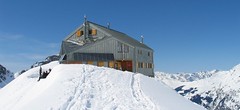


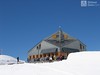

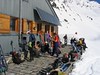


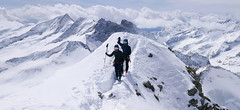
The modern mountain hut Cabane FXB Panossière is located above the glacier of the same name. The ski tour to the Petit Combin is great, the challenging ascent to the Grand Combin de Grafeneire is a highlight of the Alps. You can descend to the hut Cabane Chanrion via the Tournelon Blanc. The Cabane belongs to the municipality of Comune Bagnes and offers no discounts for members of the Alpine Clubs. FXB are the initials of the pilot name Francois-Xavier Bagnoud.
Tours starting from hut
Ski tours around Hut Cabane FXB Panossière
-
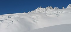
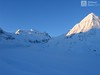
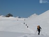
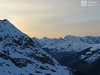
Tournelon Blanc - Cab. Panossiére 3702 m
Cabane FXB Panossière Walliser Alpen / Alpes valaisannes Switzerland
- Length of ascent7 km
- ascent1155 m
- duration4,5-6 h
- Fitness difficulty ♦♦♦◊
- Technical difficulty ♦♦♦◊
Tournelon Blanc is a challenging ski tour in the neighborhood of the Grand Combins. The passage between large crevasses in the 3000 and 3400 m zone is complicated. From the Col du Tournelon Blanc saddle to the summit without any problems. In addition to the Cabane Panossiére route, you can ski this mountain from the Cabane Chanrion hut.

-

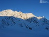
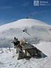
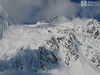
Grand Combin 4314 m
Cabane FXB Panossière Walliser Alpen / Alpes valaisannes Switzerland
- Length of ascent9 km
- ascent1720 m
- duration7,5-10 h
- Fitness difficulty ♦♦♦♦
- Technical difficulty ♦♦♦♦
Grand Combin je velmi náročnou skialpinistickou túrou, kterou lze podniknout jen za výborných podmínek - informujte se s předstihem na chatě Panossiére. Nejprve po ledovci Corbassiére na úrove'n Plateau des Maisons Blanches. Dále prudké stoupání z Plateau Déjeuner do úrovně 4000 m a pak mírným stoupání na vrchol Combin de Grafeneire.
-

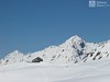
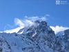
Petit Combin 3663 m
Cabane FXB Panossière Walliser Alpen / Alpes valaisannes Switzerland
- Length of ascent8 km
- ascent1150 m
- duration5-6,5 h
- Fitness difficulty ♦♦♦◊
- Technical difficulty ♦♦♦◊
Petit Combin is a flat panoramic summit with a view of the Valais Alps and the Mont Blanc massif. An ideal sightseeing tour. Ascends along the Corbassiere glacier and descends the Glacier des Follats (watch out for seracs and cracks). Finally over the glacier to Cabane FXB Panossiére.
- Country
- Switzerland
- Montains
- Walliser Alpen / Alpes valaisannes
- Open (winter)
- mid March-May
- Beds
- 100
- Winterraum
- no
- Shortening of access (cableway, lift, taxi, snowcat...)
- no
- Luggage transport
- no
- Card Pay
- yes
- Shower
- no
- Wifi
- no
- UTM / CH1903 x ("longitude" E/W)
- 589242
- UTM / CH1903 y ("latitude" N/S)
- 94138
- GPX access to hut (waipoints, track)
- FXB-Panossiere-Hut_access_skitour.gpx
- GPX access to hut (track only)
- FXB-Panosierre-Hut_access_TRK.gpx
- Map
- Arolla 283 S, Swisstopo 1:50000 Chanrion 1346, Swisstopo 1:25000
- Guides
- Ski de randonnée Bas-Valais Die klassischen Skitouren (SAC, deutsch) Les classiques de randonnée à ski (SAC, francais) Walliser Alpen (Rother, deutsch)
- Phone (hut)
- 0041(0)27 771 33 22
- Phone (valley)
- -
- Cell phone
- -
- Web
- cabane-fxb-panossiere.ch
- info@panossiere.ch
- Owner of hut
- Comune Bagnes
- Cabane FXB Panossière
- Reservation
- phone, e-mail
- Start Point
- Lourtier - Le Plamproz
- UTM / CH1903 x ("longitude" E/W)
- 588917
- UTM / CH1903 y ("latitude" N/S)
- 98014
- Altitude
- 1410 m
- Ascent (height difference)
- 1100 m
- Time of Access
- 4-5,5 h
- Shortening lift
- no
- Avalanche danger
- www.slf.ch
- Weather
- SRF Meteo Meteoschweiz snow-forecast.com mountain-forecast.com Meteoblue.com - Glacier Corbassiere Meteoblue.com - Grand Teve Meteoblue.com - Les Otanes meteo.ch - Fionnay yr.no - Grand Combin yr.no - Fionnay meteocentrale.ch - Fionnay
- Snow report
- snow-forecast.com - Verbier bergfex.ch - Verbier onthesnow.com skiresort.info snow.myswitzerland.com/
- Webcams
- Mont Fort 3300 m (Verbier) Lourtier - Val Bagnes
- Region
- Vallée de Bagnes Wallis.ch
- Public traffic
- train SBB Bus - Postauto.ch
- Skiresort nearby
- Verbier
- Other links
- Swiss Tourism
hut Cabane FXB Panossière - Reviews
There are no reviews in this section yet. Click the Add Review button to add first review.
Best ski tours in mountains Walliser Alpen / Alpes valaisannes, Switzerland
-

Pigne d´Arolla 3790 m
Cabane des Dix Walliser Alpen / Alpes valaisannes Switzerland
- Length of ascent6 km
- ascent1000 m
- duration5-7,5 h
- Fitness difficulty ♦♦◊◊
- Technical difficulty ♦♦♦◊
Pigne d´Arolla is a very popular and easily accessible viewpoint. The ski tour to the summit leads from the three mountain huts - Cabane Dix, Cabane Vignettes and Cabane Chanrion. The route from Dix goes around the glacial seracs to the saddle Col de la Serpentine and the summit can be reached on skis. A worthwhile summit on the Haute Routes to Zermatt.
-

Bishorn 4153 m
Cabane Tracuit Walliser Alpen / Alpes valaisannes Switzerland
- Length of ascent4,5 km
- ascent950 m
- duration5-6,5 h
- Fitness difficulty ♦♦♦◊
- Technical difficulty ♦♦◊◊
Bishorn seems to be a relatively light 4000, but looks are deceptive. If you include the approach to Cabane Tracuit from Zinal in the ascent, it is quite a long ski tour. From the hut the ascent line leads slightly up the glacier Turtmanngletscher. Directly below the peak on the plateau you have to swap skis for crampons and comfortably climb to the panoramic summit - one of the best in all of Valais. Driving down the northern slope is usually a fantastic enjoyment, the risk of glacier cracks is minimal.
-

Tour du Ciel - day 2 3404 m
Schönbielhütte Walliser Alpen / Alpes valaisannes Switzerland
- Length of ascent5 km
- ascent1190 m
- duration5-7 h
- Fitness difficulty ♦♦♦◊
- Technical difficulty ♦♦♦◊
Tour du Ciel (known as the reverse direction of the Haute Route Impériale) begins with the first real stage from the Schönbiel Hut, featuring a descent along the edge of the moraine. This is followed by a long, steep climb over glacier seracs, ideally tackled in the early morning. The subsequent ascent over the Hohlwäng Glacier to the Col Durand (3404 m) is then straightforward. An alternative is to turn right before the pass and climb Mont Durand. From the pass, descend over the Glacier Durand, followed by a short climb to the Cabane Mountet.
Best ski tours in Switzerland by skitour.guru
-

Piz Buin SE (Tuoihütte) 3312 m
Tuoi Chamonna / Tuoihütte Silvretta Switzerland
- Length of ascent5,5 km
- ascent1170 m
- duration5,5-7 h
- Fitness difficulty ♦♦♦◊
- Technical difficulty ♦♦♦◊
Piz Buin ze švýcarské strany je zajímavější túra než ze strany rakouské. výstup v závěrečné části je stejný. Pod stěnu vede trasa přes sedla Plan Mezdi a Fuorcla dal Cunfin. Za stabilní sněhové pokrývky je alternativou sjezd žlabem Buinlücke.
-

Chli Bielenhorn 2940 m
Andermatt - Realp - Oberalppass Urner Alps Switzerland
- Length of ascent8,5 km
- ascent1450 m
- duration5-6,5 h
- Fitness difficulty ♦♦♦◊
- Technical difficulty ♦♦◊◊
Chli Bielenhorn je skalnatá špička v říši monumentálních žulových stěn divokých hor. Začátek kolem silnice na Furkapass pokračuje po pláni pod chatou Albert-Heim-Hütte. Pak přichází v sousedství pohled na ledovce monumentálního Dammastocku. V kulisách skal vede logická linie ke skidepu kousek pod vrcholem. V případě stabilního sněhu je fajn alternativou sjezdová linie jižně od výstupové stopy a dále členitým terénem k hotelu Tiefenbach a v okolí silnice nebo po ní zpět do Realpu.
-
Grosses Grünhorn 4044 m
Mönchsjochhütte Berner Alpen / Alpes bernoises Switzerland
- Length of ascent3,5 km
- ascent970 m
- duration6-8 h
- Fitness difficulty ♦♦♦◊
- Technical difficulty ♦♦♦◊
Grosses Grünhorn je jediná 4000vka v oblasti chaty Konkordiahütte. Výstup z chaty Mönchsjochhütte vede z po ledovci Ewigschneefeld a následně po severozápadních svazích na hřeben Grünhornu. Pozor na ledovcové trhliny. Nedaleko od sedla je skidepot od kterého se jde na vrchol v mačkách. Sjezd pokračuje logicky na Konkordiaplatz a túra končí na chatě Konkordia. Tak je to ideální. Alternativou je výstup sjezd přes vrchol Grünegghorn, na který se musí vylézt s lyžemi na batohu.