
 Česky
Česky Deutsch


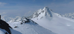
The Martin-Busch-Hütte is a large mountain hut above Vent with glacier tours in all directions - this is ideal for ski tours planning in delicate conditions. The farthest is Hintere Schwärze, the long ascent leads to the Schalfkogel. The most popular ski tours are Similaun and Hauslabkogel. Kreuzspitze is waiting directly above the M. Busch Hütte.
Tours starting from hut
Ski tours around Hut Martin-Busch-Hütte
-
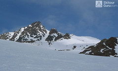
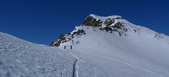
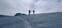
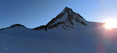
Hauslabkogel from Martin-Busch-Hütte 3403 m
Martin-Busch-Hütte Ötztal Alps / Alpi Venoste Austria
- Length of ascent4,5 km
- ascent900 m
- duration3-4,5 h
- Fitness difficulty ♦♦◊◊
- Technical difficulty ♦♦◊◊
Orientačně jednoduchá túra. Pozor na ledovcové trhliny v závěru výstupu. Skidepot kousek pod vrcholem. Z vrcholu výhled na nejznámější hory Ötztálských Alp. Příjemný sjezd po konstatně prudkém svahu. Trasa výstupu a sjezdu se shodují.

-
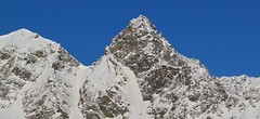
Schalfkogel West (from M.Busch Hut) 3537 m
Martin-Busch-Hütte Ötztal Alps / Alpi Venoste Austria
- Length of ascent7,5 km
- ascent1200 m
- duration4,5-6 h
- Fitness difficulty ♦♦♦◊
- Technical difficulty ♦♦♦◊
Túra na Schalfkogel od chaty Martin Busch Hütte začíná sjezdem do údolí a pokračuje úzkým koridorem pod ledovcovými morénami východním směrem do sedla Schalfkogeljoch. Zde je skidepot a na vrchol v mačkách a s cepínem. Dolů po trase výstupu.
-
Hintere Schwärze 3624 m
Martin-Busch-Hütte Ötztal Alps / Alpi Venoste Austria
- Length of ascent6,5 km
- ascent1300 m
- duration5,5-7 h
- Fitness difficulty ♦♦◊◊
- Technical difficulty ♦♦♦◊
Hintere Schwärze je vrchol, schovaný trošku stranou. Patří mezi top10 nejvyšších hor Rakouska. Po sjezdu od chaty se trasa stáčí doprava na ledovec Marzellferner. Po ledovci mírně nahoru. Následuje prudší svah k závěrečnému výšvihu. Od skidepa v mačkách a s cepínem na vrchol, jednoduchým terénem.
-
Finailspitze East (from M.Busch Hütte) 3514 m
Martin-Busch-Hütte Ötztal Alps / Alpi Venoste Austria
- Length of ascent6 km
- ascent1040 m
- duration5,5-7 h
- Fitness difficulty ♦♦♦◊
- Technical difficulty ♦♦♦♦
Výstup na Fineilspitze východním hřebenem od chaty Martin Busch Hütte je v závěru velmi náročný, kvůli exponovanému lezení po hřebenu na vrchol. Od chaty snadno podél potoka Niedertalbach. Pod chatou Similaunhütte odbočte vpravo a stále snadným terénem dojdete až k památníku nálezu "ledového muže - Ötziho. Nastává první prudší výstup do sedla Hauslabjoch. Kousek pod sedlem je příhodné místo na skidepot. V mačkách po vzdušném hřebenu na vrchol, který poskytuje spektakulární výhledy. Velký pozor při sestupu. Pokud se nechcete vrátit na chatu M.Busch Hütte nebo Similaunhütte můžete sjet do ledovci směrem k chatě Hochjoch Hospiz. Obtížnější variantou je přelézt hřeben s lažemi na batohu a západním hřebenem sestoupit k chatě Rifugio Bella Vista.
-

Similaun N, from Martin-Busch-Hütte 3606 m
Martin-Busch-Hütte Ötztal Alps / Alpi Venoste Austria
- Length of ascent7 km
- ascent1100 m
- duration4,5-6 h
- Fitness difficulty ♦♦♦◊
- Technical difficulty ♦♦♦◊
6. nejvyšší hora Rakouska Similaun je oblíbeným skialpinistickým vrcholem. Příjemně mírným svahem míří stopa až na místo, kde se lyže vymění za mačky a cepín. Chodeckým terénem po širokém hřebínku bez expozice dojdete k vrcholovému kříži. Při sjezdu se při dostatku sněhu nabízí severní varianta (při sjezdu se držte vpravo) pod Marzellkammspitze.
- Country
- Austria
- Montains
- Ötztal Alps / Alpi Venoste
- Open (winter)
- March - mid May
- Beds
- 105
- Winterraum
- open, 12 beds
- Shortening of access (cableway, lift, taxi, snowcat...)
- no
- Luggage transport
- no
- Card Pay
- no
- Shower
- yes
- Wifi
- no
- UTM / CH1903 x ("longitude" E/W)
- 32T 643990
- UTM / CH1903 y ("latitude" N/S)
- 5184789
- GPX access to hut (waipoints, track)
- MBuschHut_access_Vent_skitour.gpx
- GPX access to hut (track only)
- MBush-Hut access_Vent_TRK.gpx
- GPX all tours from the hut
- M-Busch_Hut_ALL_skitours.gpx
- Map
- Weisskugel, OEAV 1:25000, Nr. 30/2 Gurgl, OEAV 1:25000, Nr. 30/1
- Guides
- Ötztal – Silvretta / Bergverlag Rother, deusch SCHITOUREN-ATLAS ÖSTERREICH WEST / Schall Verlag, deusch Skitourenführer Ötztaler Alpen / Panico, deusch
- Phone (hut)
- +43/5254/8130
- Phone (valley)
- +43/5254/8130
- Cell phone
- +43/664/3043151
- Mobile Signal
- yes
- Web
- hotel-vent.at
- vent@netway.at
- Owner of hut
- DAV Sektion Berlin
- Martin-Busch-Hütte
- Reservation
- phone, online form
- Online reservation
- hotel-vent.at
- Start Point
- Vent
- UTM / CH1903 x ("longitude" E/W)
- 32T 64595
- UTM / CH1903 y ("latitude" N/S)
- 5191393
- Altitude
- 1885 m
- Ascent (height difference)
- 800 m
- Time of Access
- 2,5 - 3,5 h
- Shortening lift
- no
- Avalanche danger
- lawine.at
- Weather
- Hochjoch Hospiz / meteoblue.com Bergwetter Tirol 2 days Vent, snow-forecast.com Similaun 3606 / mountain-forecast.com Kreuzspitze 3457 / mountain-forecast.com Mutmalspitze 3522m / mountain-forecast.com Schalfkogel 3540 m / mountain-forecast.com Hintere Schwärze 3628m / mountain-forecast.com Alpenvereinswetter ZAMG - Austria ORF Wetter
- Snow report
- Vent / bergfex.at Vent / snow-forecast.com Sölden / schneeradar.de Sölden / onthesnow.com Schnalstal / snow-forecast.com
- Webcams
- Vernagthütte Vent Rif. Bella Vista / Schöne Aussicht Hütte Sölden-Rettenbachgletscher
- Region
- Vent Ötztal
- Public traffic
- Postbus ÖBB Railway
- Skiresort nearby
- Sölden Vent Schnalstal - Val Senales (ITA)
- Other links
- Austria Tourism
hut Martin-Busch-Hütte - Reviews
There are no reviews in this section yet. Click the Add Review button to add first review.
Best ski tours in mountains Ötztal Alps / Alpi Venoste, Austria
-

Hohe Wilde / Hochwilde 3461 m
Langtalereckhütte Ötztal Alps / Alpi Venoste Austria
- Length of ascent8 km
- ascent1040 m
- duration6-8 h
- Fitness difficulty ♦♦♦◊
- Technical difficulty ♦♦♦♦
Hohe Wilde (Langtalereck Hütte, Ötztaler Alpen) is a distinctive mountain at the end of the Langtaler Ferner glacier with a challenging finisch to the summit.
-
Finailspitze North (from Hochjoch Hospiz) 3514 m
Hochjoch Hospiz Ötztal Alps / Alpi Venoste Austria
- Length of ascent7 km
- ascent1390 m
- duration5,5-7 h
- Fitness difficulty ♦♦♦◊
- Technical difficulty ♦♦♦◊
The tour to Fineilspitze begins with a short descent from the Hochjoch Hospiz hut into the valley of the Rofenache stream. Cross the stream and ascend on the right-hand side above the gorge. After the valley widens, continue left up over a moraine onto the glacier. On the glacier, head right of the ridge to a point at 3447 m. Leave the skis there and continue without them, using crampons, over exposed terrain along the ridge to the summit. Descent follows the ascent route.
-

Mittlerer Seelenkogel 3426 m
Langtalereckhütte Ötztal Alps / Alpi Venoste Austria
- Length of ascent5 km
- ascent1000 m
- duration4-5,5 h
- Fitness difficulty ♦♦◊◊
- Technical difficulty ♦♦♦◊
Mittlerer Seelenkogel (Langtalereck Hütte, Ötztaler Alpen) is a rather difficult skitour for his second half. Traverse in steep terrain and the finish can be done under good conditions only.
Best ski tours in Austria by skitour.guru
-
Silvrettahorn 3244 m
Wiesbadener Hütte Silvretta Austria
- Length of ascent5 km
- ascent960 m
- duration5-6,5 h
- Fitness difficulty ♦♦♦◊
- Technical difficulty ♦♦♦◊
The ascent to the Silvrettahorn is one of the most popular excursion destinations of the Wiesbadener Hütte. After crossing the Ochsentaler Glacier, the ascent line turns right. The climb continues in the direction of Egghornlücke, but still turns right under the saddle. From the ski depot without skis over Westgrat to the summit.
-

Hoher Sonnblick 3105 m
Kolm Saigurn - Sonnblickbasis Goldberg Gruppe - Hohe Tauern Austria
- Length of ascent8 km
- ascent1507 m
- duration5-7 h
- Fitness difficulty ♦♦♦◊
- Technical difficulty ♦♦◊◊
Hoher Sonnblick (Goldberggruppe - Hohe Tauern) is a popular tour from Kolm Saigurn Hut. At the top you can have a beer at the Zittelhaus cottage. Excellent alpine ski school, downhill slopes of various expositions and snow.
-

Kreuzspitze 2624 m
Kalkstein - Villgratental Villgratner Berge - Deferegger Alpen Austria
- Length of ascent5,5 km
- ascent955 m
- duration3,5-5 h
- Fitness difficulty ♦♦◊◊
- Technical difficulty ♦♦◊◊
Túra na Kreuzspitze patří k nejoblíbenějším v oblasti Kalksteinu. Široký svah nabízí variabilitu sjezdové trasy. Od mohtného kříže na vrcholu je parádní výhled.