
 Česky
Česky Deutsch


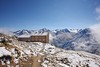


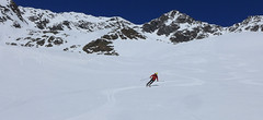
The Breslauer Hütte is an ideal starting point to climb the Wildspitze, the highest mountain in the Ötztaler Alps. In winter there is no staff, there is a winter room available. The house is accessible from Vent. If a chairlift is in operation (usually until Easter) you can shorten the approach to the mountain hut considerably.
Tours starting from hut
Ski tours around Hut Breslauer Hütte
- Country
- Austria
- Montains
- Ötztal Alps / Alpi Venoste
- Open (winter)
- in winter is closed
- Beds
- 166
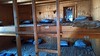
- Winterraum
- open, 22 beds
- Shortening of access (cableway, lift, taxi, snowcat...)
- yes, by cableway from Vent
- Luggage transport
- no
- Card Pay
- no
- Shower
- no
- Wifi
- no
- UTM / CH1903 x ("longitude" E/W)
- 32T 643241
- UTM / CH1903 y ("latitude" N/S)
- 5192223
- GPX access to hut (waipoints, track)
- Breslauer-Hut_access_Vent_skitour.gpx
- GPX access to hut (track only)
- BreslauerH_access_TRK.gpx
- GPX all tours from the hut
- Wildspitze_Breslauer-Hut_skitour.gpx
- Map
- Ötztaler Alpen Wildspitze, OEAV 1:25000, Nr. 30/6 Ötztaler Alpen Weisskugel, OEAV 1:25000, Nr. 30/2
- Guides
- Ötztal – Silvretta / Bergverlag Rother, deusch SCHITOUREN-ATLAS ÖSTERREICH WEST / Schall Verlag, deusch Skitourenführer Ötztaler Alpen / Panico, deusch
- Phone (hut)
- 0043/664/5300898
- Phone (valley)
- 0043/5254/30117
- Cell phone
- -
- Mobile Signal
- yes
- Web
- BreslauerHuette.at
- info@breslauerhuette.at
- Owner of hut
- DAV Sektion Breslau / Sitz Stuttgart
- Start Point
- Vent
- UTM / CH1903 x ("longitude" E/W)
- 32T 64595
- UTM / CH1903 y ("latitude" N/S)
- 5191393
- Altitude
- 1885 m
- Ascent (height difference)
- 970 m
- Time of Access
- 2-3 h
- Shortening lift
- yes, by cablecar from Vent, until mid April
- Avalanche danger
- lawine.at
- Weather
- Breslauer Hütte / yr.no Vent skiresort, snow-forecast.com Wildspitze 3772m / mountain-forecast.com Hint. Brochkogel 3625m / mountain-forecast.com Ramolkogel 3549m / mountain-forecast.com Bergwetter Tirol 2 days Alpenverein.at Austria / ZAMG Tirol / ORF
- Snow report
- Vent / bergfex.at Vent / snow-forecast.com Sölden / onthesnow.com Sölden / schneeradar.de
- Webcams
- Vent Vernagthütte Rif. Bella Vista / Schöne Aussicht Hütte Sölden-Rettenbachgletscher
- Region
- Vent Ötztal
- Public traffic
- OBB Raiway Postbus
- Skiresort nearby
- Vent Pitztaler Gletscher Sölden
- Other links
- Austria Tourism
hut Breslauer Hütte - Reviews
There are no reviews in this section yet. Click the Add Review button to add first review.
Best ski tours in mountains Ötztal Alps / Alpi Venoste, Austria
-

Hohe Wilde / Hochwilde 3461 m
Langtalereckhütte Ötztal Alps / Alpi Venoste Austria
- Length of ascent8 km
- ascent1040 m
- duration6-8 h
- Fitness difficulty ♦♦♦◊
- Technical difficulty ♦♦♦♦
Hohe Wilde (Langtalereck Hütte, Ötztaler Alpen) is a distinctive mountain at the end of the Langtaler Ferner glacier with a challenging finisch to the summit.

-
Finailspitze North (from Hochjoch Hospiz) 3514 m
Hochjoch Hospiz Ötztal Alps / Alpi Venoste Austria
- Length of ascent7 km
- ascent1390 m
- duration5,5-7 h
- Fitness difficulty ♦♦♦◊
- Technical difficulty ♦♦♦◊
The tour to Fineilspitze begins with a short descent from the Hochjoch Hospiz hut into the valley of the Rofenache stream. Cross the stream and ascend on the right-hand side above the gorge. After the valley widens, continue left up over a moraine onto the glacier. On the glacier, head right of the ridge to a point at 3447 m. Leave the skis there and continue without them, using crampons, over exposed terrain along the ridge to the summit. Descent follows the ascent route.
-
Similaun N, from Similaunhütte 3606 m
Similaunhütte - Rifugio Similaun Ötztal Alps / Alpi Venoste Austria
- Length of ascent3 km
- ascent650 m
- duration2,5-3,5 h
- Fitness difficulty ♦♦◊◊
- Technical difficulty ♦♦♦◊
Vrchol Similaun od chaty Similaunhütte vede po severovýchodních svazích, převážně po ledovci Niederjochferner. Od chaty na lyžích do skidepotu, a v mačkách s cepínem k vrcholovému kříži.
Best ski tours in Austria by skitour.guru
-

Festkogel 2269 m
Johnsbach - Kölblwirt Gesäuse Austria
- Length of ascent5,5 km
- ascent1430 m
- duration6-8 h
- Fitness difficulty ♦♦♦◊
- Technical difficulty ♦♦♦◊
Festkogel is a very attractive ski tour between the rocks with a breathtaking view of the whole Gesäuse and the Enns valley. From the parking (of the Hesshütte), nearby the restaurant and Hotel Kölblwirt towards the waterfall along the trail. Continue through a steep narrow rock ditch towards the tower Schneekarturm. Around the tower until the last part of the climb. By frequent crossing of steep slopes, the Festkogel is recommended a ski trip in stable conditions.
-

Nockberge Trail Day 4 2331 m
Falkertsee Nockberge Austria
- Length of ascent4 km
- ascent690 m
- duration4,5-5,5 h
- Fitness difficulty ♦♦◊◊
- Technical difficulty ♦♦◊◊
Poslední, 4. etapa Nockberge Trail začíná na Falkertsee. Vyjedete vlekem nahoru a na pásech vystoupáte do sedla Hundsfeldscharte. Žlaben Hundsfeldgraben sjedete k chatě Hundsfeldhütte a traverzujete směrem k cestě na Steinalm. Odtud po širokých svazích na vrchol Klomnock. Odtud sjezd jihozápadním směrem a pak krátký výstup na Mallnock. Z vrcholu po plochém hřebenu na lyžích až k horní stanici lanovky Brunnachalm s krásnou novou hospodou. Po sjezdovce dolů do St. Oswaldu. Po túře relax v termálních lázních v Bad Kleinkirchheimu. Pokud nechcete spát na Falkertsee je logisticky jednodušší zahájit túru v St. Oswald a na uvedenou trasu se napojit před Steinalmem.
-
Ruderhofspize S (from Stubai Valley) 3473 m
Stubai - Mutterbergalm (cable car) Stubai Alps Austria
- Length of ascent6,5 km
- ascent1770 m
- duration5,5-7 h
- Fitness difficulty ♦♦♦◊
- Technical difficulty ♦♦◊◊
Ruderhofspitze je velkolepá túra širokým jižním svahem, až poslední desítky metrů se musí jít bez lyží. Sjezd po trase výstupu je víceméně příjemného sklonu, většinou mezi 20-25 stupni a hlavně na jarním firnu to je velkolepé svezení.