
 Česky
Česky Deutsch


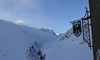


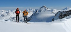
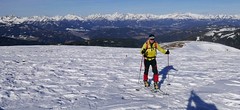
The Hochjoch Hospiz is a mountain hut that can be reached from Vent along the Rofen Ache stream. In some sections, the approach to the hut can be adventurous. From the hut are frequent destinations for ski mountaineers the monumental Weißkugel, the Fineilspitze (Similaunhütte) and the Guslarspitze (Vernagthütte). The Hochjoch Hospiz is the base on Venter Skicircuit, 5-day haute route through the Ötztal Alps.
Tours starting from hut
Ski tours around Hut Hochjoch Hospiz
-

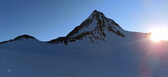
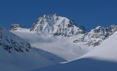
Weisskugel East, from Hochjoch Hospiz 3739 m
Hochjoch Hospiz Ötztal Alps / Alpi Venoste Austria
- Length of ascent11 km
- ascent1550 m
- duration7-10 h
- Fitness difficulty ♦♦♦♦
- Technical difficulty ♦♦♦◊
Skialpinistická túra na Weisskugel je obtížná především svou délkou. Začátek túry se liší podle sněhové situace. Když je málo sněhu, jde se po rampě, víceméně po vrstevnici k ledovci Hintereisferner. Po ledovci mírně nahoru západním směrem. Prudký je až výšvih do sedla Hintereisjoch, odkud se stoupá doprava, severním směrem k vrcholu. Poslední desítky metrů vedou exponovaným terénem, hodně záleží na množství sněhu.

-

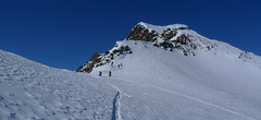
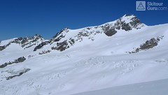
Fluchtkogel S, from Hochjoch Hospiz 3500 m
Hochjoch Hospiz Ötztal Alps / Alpi Venoste Austria
- Length of ascent6 km
- ascent1130 m
- duration3,5-5 h
- Fitness difficulty ♦♦♦◊
- Technical difficulty ♦♦◊◊
Skialpová túra na Fluchtkogel z chaty Hochjoch Hospiz slibuje zajímavý výstup a skvělý výhled z vrcholu. Od chaty traverzem mírně vzhůru (ne moc doprava nahoru) tak, abyste dosáhli spodního okraje ledovcového karu. Úzkým koridorem po prudším výšvihu ke spodnímu okraji ledovce Kesselwandferner. Po mírném rozlehlém ledovci k sedlu Guslarjoch. Závěr výstupu na plochý vrchol je po místy prudkém svahu. Pokud chcete sjet k chatě Vernagthütte, z vrcholu sjeďtze k sedlu Guslarjoch a po ledovci Guslarferner a následně členitým terénem k chatě. V případě návratu na Hochjoch Hospiz sjezd po trase výstupu.
-
Finailspitze North (from Hochjoch Hospiz) 3514 m
Hochjoch Hospiz Ötztal Alps / Alpi Venoste Austria
- Length of ascent7 km
- ascent1390 m
- duration5,5-7 h
- Fitness difficulty ♦♦♦◊
- Technical difficulty ♦♦♦◊
The tour to Fineilspitze begins with a short descent from the Hochjoch Hospiz hut into the valley of the Rofenache stream. Cross the stream and ascend on the right-hand side above the gorge. After the valley widens, continue left up over a moraine onto the glacier. On the glacier, head right of the ridge to a point at 3447 m. Leave the skis there and continue without them, using crampons, over exposed terrain along the ridge to the summit. Descent follows the ascent route.
-

Guslarspitze S, from Hochjoch Hospiz 3138 m
Hochjoch Hospiz Ötztal Alps / Alpi Venoste Austria
- Length of ascent3 km
- ascent720 m
- duration2-3 h
- Fitness difficulty ♦♦◊◊
- Technical difficulty ♦♦◊◊
Túra na Guslarspitze z chaty Hochjoch Hospiz není příliš náročná. Stoupá se přímo z chaty jižním svahem. Sklon svahu se plynule zvětšuje. Po vrcholovém hřebenu je to kousek ke kříži. Sjezd po trase výstupu. Přes Guslarspitze vede nejjednodušší trasa k chatě Vernagthütte.
- Country
- Austria
- Montains
- Ötztal Alps / Alpi Venoste
- Open (winter)
- March - beginning May
- Beds
- 70
- Winterraum
- open, 16 beds
- Shortening of access (cableway, lift, taxi, snowcat...)
- no
- Luggage transport
- no
- Card Pay
- no
- Shower
- yes
- Wifi
- yes
- UTM / CH1903 x ("longitude" E/W)
- 32T 639906
- UTM / CH1903 y ("latitude" N/S)
- 5187362
- GPX access to hut (waipoints, track)
- HochjochHospiz_access_Vent_skitour.gpx
- GPX access to hut (track only)
- HochjochH_access_Vent_TRK.gpx
- GPX all tours from the hut
- HochjochH_ALL_skitour.gpx
- Map
- Weisskugel, OEAV 1:25000, Nr. 30/2
- Guides
- Ötztal – Silvretta / Bergverlag Rother, deusch SCHITOUREN-ATLAS ÖSTERREICH WEST / Schall Verlag, deusch Skitourenführer Ötztaler Alpen / Panico, deusch
- Phone (hut)
- +43 720 920311
- Phone (valley)
- -
- Cell phone
- +43 (0) 664 7980757
- Mobile Signal
- yes
- Web
- hochjoch-hospiz.at
- info@hochjoch-hospiz.at
- Owner of hut
- DAV Sektion Berlin
- Hochjoch Hospiz
- Reservation
- online form
- Online reservation
- hochjoch-hospiz.at
- Start Point
- Rofenhöfen / Vent
- UTM / CH1903 x ("longitude" E/W)
- 10.891094°
- UTM / CH1903 y ("latitude" N/S)
- 5190866
- Altitude
- 2020 m
- Ascent (height difference)
- 640 m
- Time of Access
- 2,5 - 3 h
- Shortening lift
- no
- Avalanche danger
- lawine.at
- Weather
- Hochjoch Hospiz / meteoblue.com Bergwetter Tirol 2 days Vent, snow-forecast.com Guslarspitzen 3147 / mountain-forecast.com Fineilspitze 3514 / mountain-forecast.com Fluchtkogel / meteoblue.com Weisskugel 3739 m / mountain-forecast.com Alpenvereinswetter wetter.at - Austria ZAMG - Austria ORF Wetter
- Snow report
- Vent / bergfex.at Vent / snow-forecast.com Sölden / schneeradar.de Sölden / onthesnow.com
- Webcams
- Vernagthütte Vent Rif. Bella Vista / Schöne Aussicht Hütte Sölden-Rettenbachgletscher
- Region
- Vent Ötztal
- Public traffic
- Postbus
- Skiresort nearby
- Sölden
- Other links
- Austria Tourism
hut Hochjoch Hospiz - Reviews
There are no reviews in this section yet. Click the Add Review button to add first review.
Best ski tours in mountains Ötztal Alps / Alpi Venoste, Austria
-

Hohe Wilde / Hochwilde 3461 m
Langtalereckhütte Ötztal Alps / Alpi Venoste Austria
- Length of ascent8 km
- ascent1040 m
- duration6-8 h
- Fitness difficulty ♦♦♦◊
- Technical difficulty ♦♦♦♦
Hohe Wilde (Langtalereck Hütte, Ötztaler Alpen) is a distinctive mountain at the end of the Langtaler Ferner glacier with a challenging finisch to the summit.
-
Schalfkogel West (from M.Busch Hut) 3537 m
Martin-Busch-Hütte Ötztal Alps / Alpi Venoste Austria
- Length of ascent7,5 km
- ascent1200 m
- duration4,5-6 h
- Fitness difficulty ♦♦♦◊
- Technical difficulty ♦♦♦◊
Túra na Schalfkogel od chaty Martin Busch Hütte začíná sjezdem do údolí a pokračuje úzkým koridorem pod ledovcovými morénami východním směrem do sedla Schalfkogeljoch. Zde je skidepot a na vrchol v mačkách a s cepínem. Dolů po trase výstupu.
-
Fluchtkogel SE, from Vernagthütte 3500 m
Vernagthütte Ötztal Alps / Alpi Venoste Austria
- Length of ascent4 km
- ascent740 m
- duration3-4,5 h
- Fitness difficulty ♦♦♦◊
- Technical difficulty ♦♦◊◊
Túra na Fluchtkogel z Vernagthütte je výletem za krásnými výhledy přes celé Ötztálské Alpy. Jediný prudší úsek je pod sedle Oberes Guslarjoch a ještě v závěrečném svahu na plochý vrchol. Dolů kolem výstupových stop.
Best ski tours in Austria by skitour.guru
-
Nockberge Trail Day 1 2214 m
Katschberghöhe Nockberge Austria
- Length of ascent8,5 km
- ascent1060 m
- duration6-8 h
- Fitness difficulty ♦♦♦◊
- Technical difficulty ♦♦◊◊
Nockberge Trail je panoramacká 4 denní skialpinistická trasa v korutanském pohoří Nockberge. 1. etapa začíná výjezdem lanovkou z Katschbergu na vrchol Ainecku (když je silný vítr, lanovka nejede a je potřeba vystoupat na pásech). Ze sjezdovky na svahy hory Teuerlnock. Hezký mírný sjezd směrem k Bonnerhütte (zavřená). Následuje výstup na alm a kvěma serpentinami dolů (pásy se nevyplatí sundávat). Na lavičce u chaty Lausnitzalm svačinka. Nad východním břehem jezera Lausnitrealm vstup na náhorní plošinu a střídání nahorů - dolů, na pásech. Z vrcholu Gaipahöhe buď sjezd do Innerkrems (hotely) nebo stále vrchem přes sjezdovky skiresortu na východ a sjez na chatu Dr.-Joseh-Mehrl-Hütte. Orientačně náročná trasa, raději s GPS navigací
-
Dreiherrnspitze 3499 m
Essener-Rostocker Hütte Venedigergruppe - Hohe Tauern Austria
- Length of ascent8,6 km
- ascent1430 m
- duration9-11 h
- Fitness difficulty ♦♦♦♦
- Technical difficulty ♦♦♦◊
The Dreiherrnspitze is a spectacular, complex and challenging glacier ski tour. Especially difficult is its length, glacial cracks and terrain break at the end. First, it is easy to climb glacier the Südl. Malhamkees to Regentörl saddle. After a short downhill northwards to the Umbalkees Glacier, the traverse between the cracks and then to the Althauskees. Relatively steep slope to difficult terrain break (depending on snow conditions). After overcoming it, there is only 200 high meters in easy terrain. Downhill same track as ascent.
-
Vordere Jamspitze from Jamtalhütte 3154 m
Jamtalhütte Silvretta Austria
- Length of ascent6 km
- ascent1050 m
- duration4,5-6 h
- Fitness difficulty ♦♦◊◊
- Technical difficulty ♦♦♦◊
Jamspitze is a very popular skitour from the Jamtalhütte. It is a light ski tour along the Jamtalferner glacier to the Jamspitze saddle. The saddle is followed by a sharp slope without skis in crampons.