
 Česky
Česky Deutsch


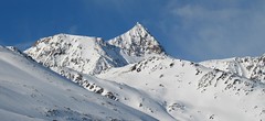
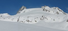
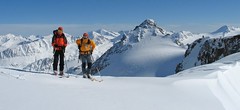
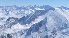
Vernagthütte is classic mountain hut in the glacier empire, high above Vent. Access to hut is not easy tour. Vernagt hut is exit point for Guslarspitze (Hochjoch Hospiz hut), Fluchtkogel, Hochvernagtspitze and the glacier Vernagtgletscher on the Wildspitz - second highest peak of Austria.
Tours starting from hut
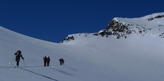
Ski tours around Hut Vernagthütte
-
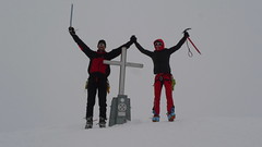
Wildspitze - Vernagt Hütte to Vent 3770 m
Vernagthütte Ötztal Alps / Alpi Venoste Austria
- Length of ascent7,5 km
- ascent1100 m
- duration7-9 h
- Fitness difficulty ♦♦♦◊
- Technical difficulty ♦♦♦♦
Trasa výstupu je shodná z túrou z chaty Vernagthütte. Při sjezdu odbočte doleva k sedlu Mitterkarjoch. Velký pozor na trhliny na okraji ledovce. Varianta z ledovce doleva vede strmým, vysněženým svahem. Varianta pravá, přes Mitterkarjoch poskytuje při nižší sněhové pokrývce sestup přes feratu obtížnosti B/C. Po vyjetí ze strmých svahů traverzujtedoleva s co nejmenší ztrátou výšky velkým kotlem k chatě Breslauer. Od chaty zpočátku přes strmý svah k horní stanici lanovky ze skiareálu Vent. Po sjezdovkách dolů na parkoviště. Túra jen pro zkušené alpinisty - výborné lyžaře a schopnosti lézt ve skalním terénu!

-

Wildspitze W - Vernagt Hütte 3770 m
Vernagthütte Ötztal Alps / Alpi Venoste Austria
- Length of ascent7,5 km
- ascent1100 m
- duration5,5-7 h
- Fitness difficulty ♦♦♦◊
- Technical difficulty ♦♦♦◊
Výstup na Wildspize, nejvyšší horu Tyrolska je nejjednodušší z horské chaty Vernagt Hütte. Je to náročná, poměrně dlouhá ledovcová túra. Nejobtížnějším místem je výstup do sedla Brochkogeljoch (pozor na lavinu). Většinou je nutné nasadit mačky. Následuje dlouhá ledovcová pláň a pak prudší výstup na závěrečné plató. Na jeho okraji odložte lyže (skidepot) a v mačkách a s cepínem po hřebeni k vrcholovému kříži. Pozor na převěje při větším množství sněhu.
-
Hochvernagtspitze 3539 m
Vernagthütte Ötztal Alps / Alpi Venoste Austria
- Length of ascent5 km
- ascent790 m
- duration4-5,5 h
- Fitness difficulty ♦♦◊◊
- Technical difficulty ♦♦♦◊
Túra z chaty Vernagthütte na Hochvernagtspitze vede zajímavou ledovcovou krajinou. Po překonání prudkého ledovcového zlomu dojdete k východnímu okraji skalnatého hřebene. Odložíte lyže a pomocí maček a cepínu po hřebeni střídavě nahoru a dolů na vrchol. Pozor při nestabilní konzistenci sněhu! Sjezd po trase výstupu.
-

Guslarspitze N - Vernagthütte 3138 m
Vernagthütte Ötztal Alps / Alpi Venoste Austria
- Length of ascent2,5 km
- ascent450 m
- duration1,5-2,5 h
- Fitness difficulty ♦◊◊◊
- Technical difficulty ♦♦◊◊
Túra na Guslarspitze je nejjednodušší v oblasti chaty Vernagthütte. Svah prudší než 3 stupňů je jen kousek pod vrcholem. Přes vrchol vede nejkratší cesta na sousední chatu Hochjoch Hospiz. Tato túra je bez vrcholové pasáže alternativou pro dny se špatným počasím.
-
Fluchtkogel SE, from Vernagthütte 3500 m
Vernagthütte Ötztal Alps / Alpi Venoste Austria
- Length of ascent4 km
- ascent740 m
- duration3-4,5 h
- Fitness difficulty ♦♦♦◊
- Technical difficulty ♦♦◊◊
Túra na Fluchtkogel z Vernagthütte je výletem za krásnými výhledy přes celé Ötztálské Alpy. Jediný prudší úsek je pod sedle Oberes Guslarjoch a ještě v závěrečném svahu na plochý vrchol. Dolů kolem výstupových stop.
- Country
- Austria
- Montains
- Ötztal Alps / Alpi Venoste
- Open (winter)
- March - mid May
- Beds
- 90
- Winterraum
- 29
- Shortening of access (cableway, lift, taxi, snowcat...)
- no
- Luggage transport
- no
- Card Pay
- no
- Shower
- yes
- Wifi
- no
- UTM / CH1903 x ("longitude" E/W)
- 32 T 639043
- UTM / CH1903 y ("latitude" N/S)
- 5190513
- GPX access to hut (waipoints, track)
- VernagtH_Vent_access_skitour.gpx
- GPX access to hut (track only)
- VernagtH access_TRK.gpx
- GPX all tours from the hut
- VernagtH_ALL_skitours.gpx
- Map
- Wildspitze, OEAV 1:25000, Nr. 30/6 Weisskugel, OEAV 1:25000, Nr. 30/2
- Guides
- Ötztal – Silvretta / Bergverlag Rother, deusch SCHITOUREN-ATLAS ÖSTERREICH WEST / Schall Verlag, deusch Skitourenführer Ötztaler Alpen / Panico, deusch
- Phone (hut)
- +43(0)664/1412119
- Phone (valley)
- +43 (0)720 920315
- Cell phone
- 0043/5254/8128
- Mobile Signal
- yes
- Web
- vernagthuette.de
- info@wieshof.at
- Owner of hut
- DAV Sektion Würzburg
- Vernagthütte 2.755m
- Reservation
- online form
- Online reservation
- alpsonline.org
- Start Point
- Vent
- UTM / CH1903 x ("longitude" E/W)
- 32 T 645899
- UTM / CH1903 y ("latitude" N/S)
- 5191358
- Altitude
- 1885 m
- Ascent (height difference)
- 890 m
- Time of Access
- 3-4 h
- Shortening lift
- no
- Avalanche danger
- lawine.at
- Weather
- Vernagthütte / meteoblue.com Vernagthuette / yr.no Bergwetter Tirol 2 days Vent, snow-forecast.com Hochvernagtspitze 3539 / mountain-forecast.com Wildspitze 3772 / mountain-forecast.com Guslarspitzen 3147 / mountain-forecast.com Fluchtkogel 3500 / mountain-forecast.com Fluchtkogel / meteoblue.com Hint. Brochkogel 3625m / mountain-forecast.com Alpenvereinswetter wetter.at - Austria ZAMG - Austria ORF Wetter
- Snow report
- Vent / bergfex.at Vent / snow-forecast.com Sölden / schneeradar.de Sölden / onthesnow.com
- Webcams
- Vernagthütte Vent Rif. Bella Vista / Schöne Aussicht Hütte Sölden-Rettenbachgletscher
- Region
- Vent Ötztal
- Public traffic
- Postbus
- Skiresort nearby
- Sölden
- Other links
- Austria Tourism
hut Vernagthütte - Reviews
There are no reviews in this section yet. Click the Add Review button to add first review.
Best ski tours in mountains Ötztal Alps / Alpi Venoste, Austria
-

Hohe Wilde / Hochwilde 3461 m
Langtalereckhütte Ötztal Alps / Alpi Venoste Austria
- Length of ascent8 km
- ascent1040 m
- duration6-8 h
- Fitness difficulty ♦♦♦◊
- Technical difficulty ♦♦♦♦
Hohe Wilde (Langtalereck Hütte, Ötztaler Alpen) is a distinctive mountain at the end of the Langtaler Ferner glacier with a challenging finisch to the summit.
-

Weisskugel East, from Hochjoch Hospiz 3739 m
Hochjoch Hospiz Ötztal Alps / Alpi Venoste Austria
- Length of ascent11 km
- ascent1550 m
- duration7-10 h
- Fitness difficulty ♦♦♦♦
- Technical difficulty ♦♦♦◊
Skialpinistická túra na Weisskugel je obtížná především svou délkou. Začátek túry se liší podle sněhové situace. Když je málo sněhu, jde se po rampě, víceméně po vrstevnici k ledovci Hintereisferner. Po ledovci mírně nahoru západním směrem. Prudký je až výšvih do sedla Hintereisjoch, odkud se stoupá doprava, severním směrem k vrcholu. Poslední desítky metrů vedou exponovaným terénem, hodně záleží na množství sněhu.
-
Schalfkogel E (Langtalereck H.) 3537 m
Langtalereckhütte Ötztal Alps / Alpi Venoste Austria
- Length of ascent7 km
- ascent1500 m
- duration5,5-7 h
- Fitness difficulty ♦♦♦◊
- Technical difficulty ♦♦♦◊
Schalfkogel (Langtalereck Hütte, Ötztaler Alpen) is a relatively demanding tour. After climbing the glacier Gurgler Ferner is a challenging steep steep part of the glacier Kleinleiten Ferner. From the saddle Schalfkogeljoch longer and harder ascent without skis. The mountain is also accessible from Martin Busch Hütte.
Best ski tours in Austria by skitour.guru
-
Grosser Geiger SW 3360 m
Essener-Rostocker Hütte Venedigergruppe - Hohe Tauern Austria
- Length of ascent7,5 km
- ascent1090 m
- duration5,5-7 h
- Fitness difficulty ♦♦♦◊
- Technical difficulty ♦♦♦◊
Favorite ski tour from Essener-Rostocker Hütte. Climbing the Grosser Geiger from the south leads along the Maurerkees glacier. At 2650 meters, the route turns north-westward and heads a rather steep slope towards the flat upper glacier. There is skidepo under the top pyramid. On the top of the undemanding terrain in crampons and ice axe. Follow the same route to hut.
-

Sulzfluh N 2818 m
Lindauer Hütte Rätikon Austria
- Length of ascent5,5 km
- ascent1300 m
- duration5-7 h
- Fitness difficulty ♦♦♦◊
- Technical difficulty ♦♦♦◊
Sulzfluh (Lindauer Hütte, Rätikon) is a very challenging ski tour through the rocky slopes "In der Rachen" (in the throat). From the top are great views of the mountains of eastern Switzerland and Silvretta.
-
Weisseck 2711 m
Zederhaus - Kirchenwirt Niedere Tauern Austria
- Length of ascent7 km
- ascent1450 m
- duration5-7 h
- Fitness difficulty ♦♦♦◊
- Technical difficulty ♦♦♦◊
Ski tour to the impressive Weisseck. In good conditions, a spectacular Ödenkar boiler descent is offered. If we don't climb to the Weisseck, the beautiful Ferskarspitze is on the way. Through the forest you reach the valley "In hell" (In der Hölle) - on one side of the rock towers, on the other side of the wall of Weisseck. Enter the Ödenkar from the upper plateau with the summit cross and watch out for snow guards and a very steep start.