
 Česky
Česky Deutsch


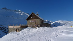
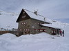
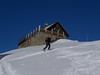
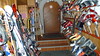
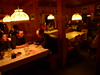

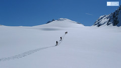
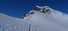
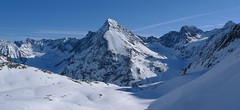
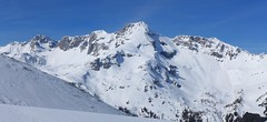
Langtalereckhütte is the mountain hut in the east of the Ötztal Alps above Obergurgl. It offers medium and very hard skitours, one of the highest areas of the Eastern Alps. Six Tours - Annakogel, Eiskögele, Hinterer Seelenkogel, Hochwilde, Mittlerer Seelenkogel, Schalfkogel, one nicer than the other. Easily accessible from the skiarea Obergurgl, help for access via the Steinmannbahn cable car.
Tours starting from hut
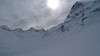
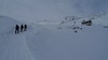
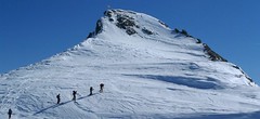
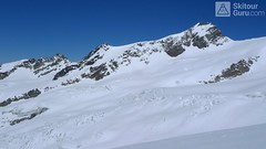
Ski tours around Hut Langtalereckhütte
-
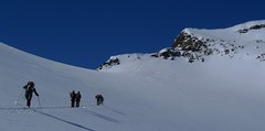
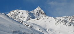
Schalfkogel E (Langtalereck H.) 3537 m
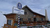
Langtalereckhütte Ötztal Alps / Alpi Venoste Austria
- Length of ascent7 km
- ascent1500 m
- duration5,5-7 h
- Fitness difficulty ♦♦♦◊
- Technical difficulty ♦♦♦◊
Schalfkogel (Langtalereck Hütte, Ötztaler Alpen) is a relatively demanding tour. After climbing the glacier Gurgler Ferner is a challenging steep steep part of the glacier Kleinleiten Ferner. From the saddle Schalfkogeljoch longer and harder ascent without skis. The mountain is also accessible from Martin Busch Hütte.

-
Hinterer Seelenkogel 3475 m
Langtalereckhütte Ötztal Alps / Alpi Venoste Austria
- Length of ascent9 km
- ascent1140 m
- duration5-7 h
- Fitness difficulty ♦♦♦◊
- Technical difficulty ♦♦◊◊
Hinterer Seelenkogel (Langtalereck Hütte, Ötztaler Alpen) is a ski tour between North and South Tyrol. Avalanche danger wait at the beginning of the exit from the Langtal valley.
-

Mittlerer Seelenkogel 3426 m
Langtalereckhütte Ötztal Alps / Alpi Venoste Austria
- Length of ascent5 km
- ascent1000 m
- duration4-5,5 h
- Fitness difficulty ♦♦◊◊
- Technical difficulty ♦♦♦◊
Mittlerer Seelenkogel (Langtalereck Hütte, Ötztaler Alpen) is a rather difficult skitour for his second half. Traverse in steep terrain and the finish can be done under good conditions only.
-
Annakogel 3336 m
Langtalereckhütte Ötztal Alps / Alpi Venoste Austria
- Length of ascent8 km
- ascent1300 m
- duration5-7 h
- Fitness difficulty ♦♦♦◊
- Technical difficulty ♦♦◊◊
ANNAKOGEL is the lightest tour of the Langtalereck Hütte on the glacier Gurgler Ferner in the Tyrol Ötztaler Alpen. Beautiful view of Schalfkogel and Hohe Wilde.
-

Hohe Wilde / Hochwilde 3461 m
Langtalereckhütte Ötztal Alps / Alpi Venoste Austria
- Length of ascent8 km
- ascent1040 m
- duration6-8 h
- Fitness difficulty ♦♦♦◊
- Technical difficulty ♦♦♦♦
Hohe Wilde (Langtalereck Hütte, Ötztaler Alpen) is a distinctive mountain at the end of the Langtaler Ferner glacier with a challenging finisch to the summit.
-

Eiskögele 3228 m
Langtalereckhütte Ötztal Alps / Alpi Venoste Austria
- Length of ascent3 km
- ascent800 m
- duration1,5-2 h
- Fitness difficulty ♦♦◊◊
- Technical difficulty ♦♦♦◊
Eiskögele is a good moderate tour for the last day on the Langtalereckhütte (Ötztaler Alpen). After climbing to the top, you can get off the saddle on the edge of the Obergurgl ski resort and down the slopes to the village.
- Country
- Austria
- Montains
- Ötztal Alps / Alpi Venoste
- Open (winter)
- mid february - mid may
- Beds
- 73
- Winterraum
- 0
- Shortening of access (cableway, lift, taxi, snowcat...)
- yes, by snowcat
- UTM / CH1903 x ("longitude" E/W)
- 32T 651928
- UTM / CH1903 y ("latitude" N/S)
- 5188048
- GPX access to hut (waipoints, track)
- Langtalereck-Huette-access.gpx
- GPX access to hut (track only)
- Langtalereck Hütte access_TRK.gpx
- GPX all tours from the hut
- Langtalereck-Huette-TRACKS_WPT AUT Tirol SkitourGuru.gpx
- Map
- Gurgl, OEAV 1:25000, Nr. 30/1
- Guides
- Skitourenführer Tirol Ötztal – Silvretta SCHITOUREN-ATLAS ÖSTERREICH WEST
- Phone (hut)
- 0043/664/5268655
- Phone (valley)
- 0043/5253/5396
- Cell phone
- -
- Web
- www.alpenverein-karlsruhe.de
- -
- Owner of hut
- DAV Sektion Karlsruhe
- Langtalereckhütte & Hochwildehaus
- Start Point
- Obergurgl-parking
- UTM / CH1903 x ("longitude" E/W)
- 32 T 654452
- UTM / CH1903 y ("latitude" N/S)
- 5192814
- Altitude
- 1910 m
- Ascent (height difference)
- 600 m
- Time of Access
- 2,5-3,5 h
- Shortening lift
- Steinmannbahn
- Avalanche danger
- LWD Tirol
- Weather
- ZAMG ORF wetter.at bergfex.at yr.no - Langtalereckhütte yr.no - Mittl. Seelenkogel yr.no - Schalfkogel
- Snow report
- snow-forecast.com schneeradar.de
- Webcams
- Webcams Travel schneeradar.de
- Region
- Obergurgl Ötztal
- Public traffic
- Postbus ÖBB Railway
- Skiresort nearby
- Obergurgl-Hochgurgl
hut Langtalereckhütte - Reviews
There are no reviews in this section yet. Click the Add Review button to add first review.
Best ski tours in mountains Ötztal Alps / Alpi Venoste, Austria
-
Wildspitze - Vernagt Hütte to Vent 3770 m
Vernagthütte Ötztal Alps / Alpi Venoste Austria
- Length of ascent7,5 km
- ascent1100 m
- duration7-9 h
- Fitness difficulty ♦♦♦◊
- Technical difficulty ♦♦♦♦
Trasa výstupu je shodná z túrou z chaty Vernagthütte. Při sjezdu odbočte doleva k sedlu Mitterkarjoch. Velký pozor na trhliny na okraji ledovce. Varianta z ledovce doleva vede strmým, vysněženým svahem. Varianta pravá, přes Mitterkarjoch poskytuje při nižší sněhové pokrývce sestup přes feratu obtížnosti B/C. Po vyjetí ze strmých svahů traverzujtedoleva s co nejmenší ztrátou výšky velkým kotlem k chatě Breslauer. Od chaty zpočátku přes strmý svah k horní stanici lanovky ze skiareálu Vent. Po sjezdovkách dolů na parkoviště. Túra jen pro zkušené alpinisty - výborné lyžaře a schopnosti lézt ve skalním terénu!
-
Schalfkogel West (from M.Busch Hut) 3537 m
Martin-Busch-Hütte Ötztal Alps / Alpi Venoste Austria
- Length of ascent7,5 km
- ascent1200 m
- duration4,5-6 h
- Fitness difficulty ♦♦♦◊
- Technical difficulty ♦♦♦◊
Túra na Schalfkogel od chaty Martin Busch Hütte začíná sjezdem do údolí a pokračuje úzkým koridorem pod ledovcovými morénami východním směrem do sedla Schalfkogeljoch. Zde je skidepot a na vrchol v mačkách a s cepínem. Dolů po trase výstupu.
-

Weisskugel East, from Hochjoch Hospiz 3739 m
Hochjoch Hospiz Ötztal Alps / Alpi Venoste Austria
- Length of ascent11 km
- ascent1550 m
- duration7-10 h
- Fitness difficulty ♦♦♦♦
- Technical difficulty ♦♦♦◊
Skialpinistická túra na Weisskugel je obtížná především svou délkou. Začátek túry se liší podle sněhové situace. Když je málo sněhu, jde se po rampě, víceméně po vrstevnici k ledovci Hintereisferner. Po ledovci mírně nahoru západním směrem. Prudký je až výšvih do sedla Hintereisjoch, odkud se stoupá doprava, severním směrem k vrcholu. Poslední desítky metrů vedou exponovaným terénem, hodně záleží na množství sněhu.
Best ski tours in Austria by skitour.guru
-
Dreiherrnspitze 3499 m
Essener-Rostocker Hütte Venedigergruppe - Hohe Tauern Austria
- Length of ascent8,6 km
- ascent1430 m
- duration9-11 h
- Fitness difficulty ♦♦♦♦
- Technical difficulty ♦♦♦◊
The Dreiherrnspitze is a spectacular, complex and challenging glacier ski tour. Especially difficult is its length, glacial cracks and terrain break at the end. First, it is easy to climb glacier the Südl. Malhamkees to Regentörl saddle. After a short downhill northwards to the Umbalkees Glacier, the traverse between the cracks and then to the Althauskees. Relatively steep slope to difficult terrain break (depending on snow conditions). After overcoming it, there is only 200 high meters in easy terrain. Downhill same track as ascent.
-
Schrankogel 3497 m
Amberger Hütte Stubai Alps Austria
- Length of ascent6,5 km
- ascent1300 m
- duration4-6 h
- Fitness difficulty ♦♦♦◊
- Technical difficulty ♦♦♦♦
Schrankogel je impozantní vrchol Stubaiských Alp v oblasti Amberger Hütte. Poměrně snadný nástup na úpatí, odtud na mačkách po místy exponovaném hřebenu na vrchol.
-
Mosermandl 2677 m
Zederhaus - Kirchenwirt Niedere Tauern Austria
- Length of ascent8,5 km
- ascent1405 m
- duration6,5-7 h
- Fitness difficulty ♦♦♦◊
- Technical difficulty ♦♦♦◊
Gross Mosermandl je spolu s Weisseckem absolutním highlightem oblasti Zederhaustal v regionu Salzburger Lungau. Z parkoviště Wald se stoupá nejprve mírně údolím, pak po lesní cestě nahoru nad hranici lesa. Následují už svahy se sklonem 30 stupňů a větším. Nejobtížnější pasáž je v závěru výstupu, většinou bez lyží, v mačkách. Sjezd kopíruje trasu výstupu. Při dostatku času a sil je možné jít do Waldu přes kopec Schöpfling a místo cesty údolím si užít hezký sjezd.