
 Česky
Česky Deutsch


The Mönchsjochhütte lies at an altitude of 3650 m and is therefore the highest hut in Switzerland (managed). The Mönchsjochhütte is not far from the highest train station in Europe. The hut is an ideal starting point for ski tours to Mönch and Jungfrau.
Tours starting from hut
Ski tours around Hut Mönchsjochhütte
-
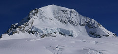
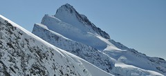
Mönch 4107 m
Mönchsjochhütte Berner Alpen / Alpes bernoises Switzerland
- Length of ascent2 km
- ascent525 m
- duration2,5-4 h
- Fitness difficulty ♦♦◊◊
- Technical difficulty ♦♦♦♦
Túra na impozantní Mnich (Mönch) je v podstatě dlouhou hřebenovkou v mačkách a s cepínem. S rostoucí výškou roste obtížnost. S úbytkem ledovcového příkrovu roste expozice. Pokud nejste horský vůdce, nepoužívejte techniku krátkého lana. V závěrečném úseku je každá chyba nevratná. Výstup přináší fantastický zážitek se spoustou výhledů na nádherný svět ledovců.

-
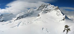
Jungfrau 4158 m
Mönchsjochhütte Berner Alpen / Alpes bernoises Switzerland
- Length of ascent6 km
- ascent1430 m
- duration4,5-7 h
- Fitness difficulty ♦♦♦◊
- Technical difficulty ♦♦♦◊
Jungfrau is a very popular 4000 in the Bernese Alps. From the highest train station in Europe - the Jungfraujoch - you can easily board. But be careful, don't climb to the top without acclimatizing! Not far from the Jungfraujoch station is the Mönchsjochhütte or above the confluence of the Aletschgletscher Konkordia Hut. The only complication of the ascent is glacier cracks. Overcoming the crevasse under the Rottasattel can be complicated. The last climb up to the summit is climbed without skis. The descent line follows the ascent track. You have to reckon with a 450 hm ascent return to the hut.
-
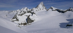
Grosses Grünhorn 4044 m
Mönchsjochhütte Berner Alpen / Alpes bernoises Switzerland
- Length of ascent3,5 km
- ascent970 m
- duration6-8 h
- Fitness difficulty ♦♦♦◊
- Technical difficulty ♦♦♦◊
Grosses Grünhorn je jediná 4000vka v oblasti chaty Konkordiahütte. Výstup z chaty Mönchsjochhütte vede z po ledovci Ewigschneefeld a následně po severozápadních svazích na hřeben Grünhornu. Pozor na ledovcové trhliny. Nedaleko od sedla je skidepot od kterého se jde na vrchol v mačkách. Sjezd pokračuje logicky na Konkordiaplatz a túra končí na chatě Konkordia. Tak je to ideální. Alternativou je výstup sjezd přes vrchol Grünegghorn, na který se musí vylézt s lyžemi na batohu.
- Country
- Switzerland
- Montains
- Berner Alpen / Alpes bernoises
- Open (winter)
- March - mid May
- Beds
- 120
- Winterraum
- 16
- Shortening of access (cableway, lift, taxi, snowcat...)
- yes, by train to Jungfraujoch or cable car Fiesch - Fiescheralp
- Luggage transport
- yes, by snowcat from Jungfraujoch
- Card Pay
- yes
- Shower
- no
- Wifi
- no
- UTM / CH1903 x ("longitude" E/W)
- 643500
- UTM / CH1903 y ("latitude" N/S)
- 156100
- GPX access to hut (waipoints, track)
- MoenchsjochHut_access_all_skitour.gpx
- GPX access to hut (track only)
- MoenchsjochHut_access_all_TRK.gpx
- GPX all tours from the hut
- MoenchsjochHut_ALL_skitour.gpx
- Map
- Jungfrau 264 S, 1:50000 Finsteraarhorn, Landeskarte Schweiz Nr. 1249, 1:25000
- Guides
- Berner Alpen Ost / SAC, deutsch Die klassischen Skitouren / SAC, deutsch Les classiques de randonnée à ski / SAC, francais Scialpinismo in Svizzera / SAC, italiano
- Phone (hut)
- +41 33 971 34 72
- Phone (valley)
- +41 79 933 08 67
- Cell phone
- -
- Mobile Signal
- yes
- Web
- moenchsjoch.ch
- info@moenchsjoch.ch
- Owner of hut
- Genossenschaft Mönchsjochhütte
- Mönchsjochhütte
- Reservation
- online
- Online reservation
- alpsonline.org
- Start Point
- Finsteraarhornhütte
- UTM / CH1903 x ("longitude" E/W)
- 651 860
- UTM / CH1903 y ("latitude" N/S)
- 152 520
- Altitude
- 3048 m
- Ascent (height difference)
- ascent 1495 hm, descent 885 hm m
- Time of Access
- 5-6,5 h
- Shortening lift
- no
- Start Point
- Konkordiahütte
- UTM / CH1903 x ("longitude" E/W)
- 647009
- UTM / CH1903 y ("latitude" N/S)
- 150087
- Altitude
- 2850 m
- Ascent (height difference)
- ascent 1100 hm, descent 175 hm, 10 k m
- Time of Access
- 3-4 h
- Shortening lift
- no
- Avalanche danger
- slf.ch - Institut für Schnee- und Lawinenforschung
- Weather
- Konkordiahuette - Meteograms Jungfraujoch / meteoblue.com Trugberg 3880m / mountain-forecast.com Gross Fiescherhorn 4049m / mountain-forecast.com Alpenvereinswetter Switzerland / meteo.ch Switzerland - animation / srf.ch
- Snow report
- Konkordiahuette - Meteograms Aletsch Arena / onthesnow.com Wengen/ snow-forecast.com Jungfrauregion / snow.myswitzerland.com
- Webcams
- Konkordiahuette Jungfraujoch Eggishorn
- Region
- Jungfrauregion
- Public traffic
- SBB Railway Bus - Postauto.ch
- Skiresort nearby
- Jungfrau Aletscharena
- Other links
- Schweiz Tourism
hut Mönchsjochhütte - Reviews
There are no reviews in this section yet. Click the Add Review button to add first review.
Best ski tours in mountains Berner Alpen / Alpes bernoises, Switzerland
-

Hubelhorn (day 4, h.r. Swiss Glacier) 3244 m
Bächlitalhütte Berner Alpen / Alpes bernoises Switzerland
- Length of ascent11,5 km
- ascent1730 m
- duration9-11 h
- Fitness difficulty ♦♦♦◊
- Technical difficulty ♦♦♦◊
The Hubelhorn skitour is an ideal extension of the crossing between the Bächlitalhütte and Gaulihütte. After a short ride from the saddle, Obri Bächlilicke climbs through the steep east slope into the rocky saddle and then slightly up the crossing to Hubelhorn. Beware of some hot spots at the Gauligletscher Glacier. From Gauli hut is a nice tour through the northern slope, but in the opposite direction.
-
Vorderes Galmihorn 3507 m
Oberaarjochhütte Berner Alpen / Alpes bernoises Switzerland
- Length of ascent2,5 km
- ascent760 m
- duration4,5-6,5 h
- Fitness difficulty ♦♦◊◊
- Technical difficulty ♦♦♦◊
Vorderes Galmihorn je skvělý skialpový vrchol na závěr akce v centru Bernských Alp. Po výstupu na vrchol z chaty Oberaletschhütte přináší skvělou možnost sjezdu do údolí Goms, což je logisticky výhodné v případě startu lanovkou z Fiesch. Výstup vede po mírném ledovci Galmigletscher a dále po přehledném svahu posetém trhlinami. Při sjezdu dávejte pozor na trhlinu pod sedlem Bächlilicke. Na jaře vás v závěru túry nemine pochod do údolí s lyžemi na batohu. Nabízí se sjezd do Reckingenu nebo Münsteru.
-
Finsteraarhorn 4374 m
Finsteraarhornhütte Berner Alpen / Alpes bernoises Switzerland
- Length of ascent3,5 km
- ascent1280 m
- duration7-9,5 h
- Fitness difficulty ♦♦♦◊
- Technical difficulty ♦♦♦♦
Na vrchol Finsteraarhorn míří náročná ledovcová túra z chaty Finsteraarhornhütte. Hned od začátku túry jsou cestou velkolepé výhledy. Náročnější je překonání skalního žebra. Po ledovci do sedla Hugisattel s leteckým pohledem na východní stěnu. Zde je skidepot a dál v mačkách a s cepínem na skialpové poměry náročným terénem. Obtížnost lezení zásadně ovlivňuje množství a konzistence sněhu na skále. Náročný sjezd prudkými svahy kopíruje linii výstupu.
Best ski tours in Switzerland by skitour.guru
-

Blanc de Moming - Dôme Circuit 3649 m
Cabane du Mountet Walliser Alpen / Alpes valaisannes Switzerland
- Length of ascent10 km
- ascent2035 m
- duration9-11 h
- Fitness difficulty ♦♦♦♦
- Technical difficulty ♦♦♦♦
Blanc de Moming - Dôme is a beautiful but also very demanding complex ski tour. First ascent from Cabane Mountet to La Forcle saddle and then not very easy descent and then ascent along the Glacier du Besso. At the end of the glacier there is an uncomfortable border between snow and rock. Climb a rocky slope. First along a flat ridge, which is increasingly exposed. It is recommended to belay in windy weather. At the beginning of the spectacular descent along the Glacier de Moming, pay attention to the gigantic cracks. The departure line (keep left) turns from the northern to the western slope. After reaching the valley there is an easy ascent along the Glacier de Zinal back to Cabane Mountet.
-

Alphubel 4206 m
Britannia Hütte Walliser Alpen / Alpes valaisannes Switzerland
- Length of ascent10 km
- ascent1450 m
- duration7-10 h
- Fitness difficulty ♦♦♦◊
- Technical difficulty ♦♦♦◊
ALPHUBEL (Britannia Hütte, Walliser Alpen) is seemingly lighter 4000vka, but over are dangerous glacial cracks. Ski alpinists can also go from the Saas Fee ski area, most not far from the cable car station Langfluh .
-

Monte Rosso 3088 m
Fornohütte - Capanna del Forno Bernina Alps Switzerland
- Length of ascent4 km
- ascent840 m
- duration4-5,5 h
- Fitness difficulty ♦♦◊◊
- Technical difficulty ♦♦♦◊
Skvělým skialpovým vrcholem uprostřed oblasti je Monte Rosso. Výhodou okruhu je maximalistický krajinářský zážitek. Po výstupu do dvou sedel se otevřou vždy nové výhledy. Od chaty míříme nejprve do sedla Sella del Forno. Koukáme na Berninu a dolů na skiresort Valmalenco. Krásným kotlem po krátkém sjezdu traverujeme a míříme nahoru do druhého sedla – Passo di Val Bona. Po strmějším svahu do místa na skalním hřebenu, kde je skidepot. Odtud v mačkách na vrchol. Na lyžích parádní sjezd jihozápadním svahem na ledovec Forno a zpět nahoru k chatě.