
 Česky
Česky Deutsch


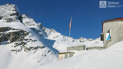


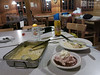


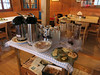
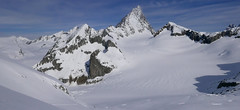
Stone, excellently furnished mountain hut in a popular climbing area. Transition point for the Swiss Glacier Haute Route. The position of the hut on the rock can complicate the safety access to the hut when avalanche situation complicate is.
Tours starting from hut
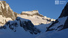
Ski tours around Hut Bächlitalhütte

- Country
- Switzerland
- Montains
- Berner Alpen / Alpes bernoises
- Open (winter)
- mid march - mid may
- Beds
- 75
- Winterraum
- open, 24 beds, cooking is posible
- Shortening of access (cableway, lift, taxi, snowcat...)
- no
- Card Pay
- no
- Shower
- no
- Wifi
- no
- UTM / CH1903 x ("longitude" E/W)
- 664 680
- UTM / CH1903 y ("latitude" N/S)
- 159 870
- GPX access to hut (waipoints, track)
- TOUR_Baechlitalhut-access.gpx
- GPX all tours from the hut
- BaechlitalHut allTOUR_WPT_SkitourGuru.gpx
- Map
- Sustenpass 255 S, Swisstopo 1:50000 Guttannen 1230, Swisstopo 1:25000
- Guides
- Skitouren Berner Alpen Ost
- Phone (hut)
- 0041 (0)33 973 11 14
- Phone (valley)
- 0041 (0) 41 495 21 30
- Cell phone
- 0041 (0) 79 614 43 69
- Mobile Signal
- no
- Web
- -
- info@baechlitalhuette.ch
- Owner of hut
- SAC Am Albis
- Start Point
- Räterichsboden
- UTM / CH1903 x ("longitude" E/W)
- 667703
- UTM / CH1903 y ("latitude" N/S)
- 160330
- Altitude
- 1710 m
- Ascent (height difference)
- 720 m
- Time of Access
- 2-2,5 h
- Shortening lift
- no
- Avalanche danger
- SLF
- Weather
- SRF Meteo Meteoschweiz snow-forecast.com - Engelberg Meteoblue - Bächlital Meteoblue - Obri Bächlilücke
- Snow report
- snow-forecast.com - Grindelwald snow-forecast.com - Melchsee-Frutt bergfex.ch - Grindelwald onthesnow.com - Grindelwald myswitzerland.com -Meiringen Hasliberg
- Webcams
- Räterichsboden Innertkirchen Guttannen Gelmersee
- Region
- Haslital Zentralschweiz Tourismus
- Public traffic
- Vlaky Linkové autobusy
- Skiresort nearby
- Grindelwald Melchsee-Frutt Andermatt - Realp
- Other links
- Guttannen Haslital Hütten
hut Bächlitalhütte - Reviews
There are no reviews in this section yet. Click the Add Review button to add first review.
Best ski tours in mountains Berner Alpen / Alpes bernoises, Switzerland
-
Grosses Grünhorn 4044 m
Konkordiahütte Berner Alpen / Alpes bernoises Switzerland
- Length of ascent7 km
- ascent1380 m
- duration6,5-8,5 h
- Fitness difficulty ♦♦♦◊
- Technical difficulty ♦♦♦◊
Gross Grünhorn is the only 4000 meter in the Konkordiahütte area. The ascent leads from Konkordiaplatz along the edge of the Ewigschneefeld glacier and then along the northwestern slopes of the Grünhorn ridge. Beware of glacier cracks around the saddle between Grünegghorn and Gross Grünhorn. Not far from the saddle is a ski depot, from which you can go up with crampons and ice ax. The descent along the ascent route is safer than the descent variant through Grüneggfirn (glacier cracks).

-
Vorderes Galmihorn 3507 m
Oberaarjochhütte Berner Alpen / Alpes bernoises Switzerland
- Length of ascent2,5 km
- ascent760 m
- duration4,5-6,5 h
- Fitness difficulty ♦♦◊◊
- Technical difficulty ♦♦♦◊
Vorderes Galmihorn je skvělý skialpový vrchol na závěr akce v centru Bernských Alp. Po výstupu na vrchol z chaty Oberaletschhütte přináší skvělou možnost sjezdu do údolí Goms, což je logisticky výhodné v případě startu lanovkou z Fiesch. Výstup vede po mírném ledovci Galmigletscher a dále po přehledném svahu posetém trhlinami. Při sjezdu dávejte pozor na trhlinu pod sedlem Bächlilicke. Na jaře vás v závěru túry nemine pochod do údolí s lyžemi na batohu. Nabízí se sjezd do Reckingenu nebo Münsteru.
-
Finsteraarhorn 4374 m
Finsteraarhornhütte Berner Alpen / Alpes bernoises Switzerland
- Length of ascent3,5 km
- ascent1280 m
- duration7-9,5 h
- Fitness difficulty ♦♦♦◊
- Technical difficulty ♦♦♦♦
Na vrchol Finsteraarhorn míří náročná ledovcová túra z chaty Finsteraarhornhütte. Hned od začátku túry jsou cestou velkolepé výhledy. Náročnější je překonání skalního žebra. Po ledovci do sedla Hugisattel s leteckým pohledem na východní stěnu. Zde je skidepot a dál v mačkách a s cepínem na skialpové poměry náročným terénem. Obtížnost lezení zásadně ovlivňuje množství a konzistence sněhu na skále. Náročný sjezd prudkými svahy kopíruje linii výstupu.
Best ski tours in Switzerland by skitour.guru
-

Breithorn - Zermatt 4164 m
Monte Rosa Hütte Walliser Alpen / Alpes valaisannes Switzerland
- Length of ascent3 km
- ascent440 m
- duration3-4 h
- Fitness difficulty ♦♦♦◊
- Technical difficulty ♦♦♦◊
Breithorn can be rated as the lightest 4000 in the Alps. In any case, thanks to the support of the Klein Matterhorn cable car, which transports ski mountaineers up to 3880 m. From the cable car station (beautiful viewpoint) to the glacier plain below the summit, which can be often reached on skis. In good conditions, it is worthwhile to continue to the Schwarztor saddle and drive descent back to Zermatt. The second variant of the freeride is the descent from the Unterer Theodulgletscher. This descent is simply great up to Seehöre 2400.
-

Piz Buin SE (Tuoihütte) 3312 m
Tuoi Chamonna / Tuoihütte Silvretta Switzerland
- Length of ascent5,5 km
- ascent1170 m
- duration5,5-7 h
- Fitness difficulty ♦♦♦◊
- Technical difficulty ♦♦♦◊
Piz Buin ze švýcarské strany je zajímavější túra než ze strany rakouské. výstup v závěrečné části je stejný. Pod stěnu vede trasa přes sedla Plan Mezdi a Fuorcla dal Cunfin. Za stabilní sněhové pokrývky je alternativou sjezd žlabem Buinlücke.
-

Tour du Ciel - day 3 3649 m
Cabane du Mountet Walliser Alpen / Alpes valaisannes Switzerland
- Length of ascent10,5 km
- ascent2420 m
- duration10-12 h
- Fitness difficulty ♦♦♦♦
- Technical difficulty ♦♦♦♦
A very long and demanding, royal stage of this Haute Route. In my opinion, the most impressive stage of all multi-day Alpine crossings. Due to the elevation gain and time required, it’s worth considering splitting the stage into two days with an overnight stay in Zinal. The long, exposed ridge to the summit requires rope protection depending on conditions. The descent is fantastically long, but caution is needed – there are large crevasses. This ski tour is only recommended in stable weather; in poor conditions, it’s advisable to bypass the Blanc de Moming via the Glacier de Zinal and ascend directly to the Cabane de Tracuit.