
 Česky
Česky Deutsch


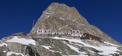


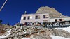
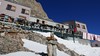


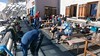
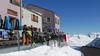
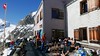
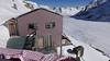

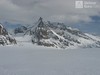

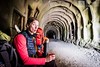

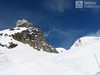

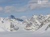


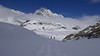


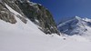
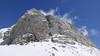


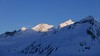
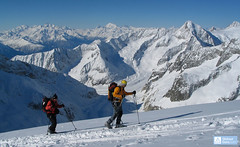
The mountain hut Konkordiahütte is located in the heart of the largest alpine glacier, Aletschgletcher. Due to the melting of glaciers, there are now 440 steps above its surface - the confluence of Konkordialplatz glaciers. Start ski tours to Gross Grünhorn, Kanzberg, Trugberg, Dreieckhorn and Jungfrau. The most convenient but also the most expensive access to the Konkordiahut is by train to Jungfraujoch. From the south - Fiesch, he boarded the Fiescheralp cable car station. From the west, a very long access from the Lötschental valley (Blatten).
Tours starting from hut
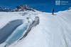
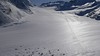
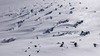
Ski tours around Hut Konkordiahütte
-

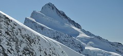
Klein Wannenhorn 3707 m
Konkordiahütte Berner Alpen / Alpes bernoises Switzerland
- Length of ascent8,5 km
- ascent1290 m
- duration6-8 h
- Fitness difficulty ♦♦♦◊
- Technical difficulty ♦♦♦◊
Túru na Klein Wannenhorn zařaďte na závěrečný den na chatě Konkordiahütte. Po výstupu můžete pokračovat dolů na Fiescheralp. Pozor na lavinový potenciál svahu, túra jen do jistých podmínek.

-

Jungfrau 4158 m
Konkordiahütte Berner Alpen / Alpes bernoises Switzerland
- Length of ascent10 km
- ascent1510 m
- duration6,5-9 h
- Fitness difficulty ♦♦♦◊
- Technical difficulty ♦♦♦◊
Skialpová túra na Jungfrau z chaty Konkordia začíná velmi dlouhým nástupem po ledovci Jungfraufirn. Následuje prudký výstup na hřeben a dále do sedla Rottalsattel přes nepříjemnou thlinu. Skidepot a na mčkách a s cepínem po plochém hřebenu na vrchol. Alternativní sjezd přes sedlo Louwitor na ledovec Aletschfirn a po něm na chatu Konkordia. Možné je po dosažení vrcholu pokračovat na nádraží Jungfraujoch nebo nocovat na Mönchsjochhütte.
-
Louwihorn 3777 m
Konkordiahütte Berner Alpen / Alpes bernoises Switzerland
- Length of ascent8,5 km
- ascent1225 m
- duration5,5-7,5 h
- Fitness difficulty ♦♦♦◊
- Technical difficulty ♦♦♦◊
Louwihorn je hodnotná alternativa výstupu na Jungfrau z chat Mönchsjochhütte i Konkordiahütte. V Každém případě vede přes sedlo Louwitor (kousek pod vrcholem) optimální linie sjezdu po sestupu z Jungfrau - po ledovci Kranzbergfirn na Konkordiaplatz a pak po schodech na Konkordiahütte. Trasa výstupu je až do výšky 3400 m shodná s túrou na Jungfrau.
-
Grosses Grünhorn 4044 m
Konkordiahütte Berner Alpen / Alpes bernoises Switzerland
- Length of ascent7 km
- ascent1380 m
- duration6,5-8,5 h
- Fitness difficulty ♦♦♦◊
- Technical difficulty ♦♦♦◊
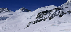
Gross Grünhorn is the only 4000 meter in the Konkordiahütte area. The ascent leads from Konkordiaplatz along the edge of the Ewigschneefeld glacier and then along the northwestern slopes of the Grünhorn ridge. Beware of glacier cracks around the saddle between Grünegghorn and Gross Grünhorn. Not far from the saddle is a ski depot, from which you can go up with crampons and ice ax. The descent along the ascent route is safer than the descent variant through Grüneggfirn (glacier cracks).
-

Kranzberg Südgipfel 3665 m
Konkordiahütte Berner Alpen / Alpes bernoises Switzerland
- Length of ascent5,5 km
- ascent1010 m
- duration4-6 h
- Fitness difficulty ♦♦◊◊
- Technical difficulty ♦♦◊◊
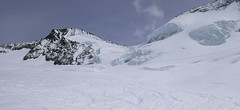
Kranzberg je nejdostupnější hora z chaty Konkordiahütte. Ze soutoku ledovců Konkordiaplatz vede stopa severozápadním směre. . Výstup vede po ledovci pod hřebenem Kanzbergu. Do výšky 3300 m se se jde po pravém okraji ledovce, pak míří stopa na patu skalního ostrohu. Za ním dorava vzhůru jižním svahem na vrcholový hřebínek a po něm na jižní vrchol Kanzbergu. Sjezd po trase výstupu nebo po ledovci Kanzbergfirn na Aletschfirn.
-

Grünegghorn 3863 m
Konkordiahütte Berner Alpen / Alpes bernoises Switzerland
- Length of ascent4,5 km
- ascent1145 m
- duration6,5-8,5 h
- Fitness difficulty ♦♦♦◊
- Technical difficulty ♦♦♦◊
Ledovcová skialpinistická túra na Grünegghorn nabízí atraktivní propojení se sousední čtyřtisícovkou Gross Grünhorn. Od chaty Konkordiahütte začíná výstup směrem k sedlu Grünhornlücke. Na úrovni výšky 3000 m zatočte vlevo na jižní svah ledovce pod Grünegghornem, jeho levou čast (při pohledu zdola). Na úrovni 3450 m vede vlevo sněhový průvlak na další ledovec. Na něm zatočte vpravo a severozápaním směren pokračujte ke kótě 3778 a po hřebenu na vrchol. S lyžemi na batohu bůžete sejít do sedla na druhé straně hory (severně pod vrcholem) a odtud bez lyží na Gross Grünhorn. Sjezd lze podniknout po jihozápadních svazích mezi velkými trhlinami na ledovec Ewigschneefäld. Takový okruh je možné podniknou i v opačném směru. Čas a převýšení se vztahují jen k výstupu na Grünegghorn z Konkordia.
- Country
- Switzerland
- Montains
- Berner Alpen / Alpes bernoises
- Open (winter)
- March - mid May
- Beds
- 155
- Winterraum
- 35
- Shortening of access (cableway, lift, taxi, snowcat...)
- yes, by train to Jungfraujoch or cable car Fiesch - Fiescheralp
- Luggage transport
- no
- Card Pay
- yes
- Shower
- yes
- Wifi
- no
- UTM / CH1903 x ("longitude" E/W)
- 647009
- UTM / CH1903 y ("latitude" N/S)
- 150087
- GPX access to hut (waipoints, track)
- KonkordiaHut_access_ALL.gpx
- GPX access to hut (track only)
- KonkordiaHut_access_ALL_TRK.gpx
- GPX all tours from the hut
- KonkordiaHut_ALL_skitour.gpx
- Map
- Jungfrau 264 S, 1:50000 Finsteraarhorn, Landeskarte Schweiz Nr. 1249, 1:25000 Aletschgletscher, Landeskarte Schweiz Nr. 1269, 1:25000
- Guides
- Berner Alpen Ost / SAC, deutsch Die klassischen Skitouren / SAC, deutsch Les classiques de randonnée à ski / SAC, francais Scialpinismo in Svizzera / SAC, italiano
- Phone (hut)
- +41 33 855 13 94
- Phone (valley)
- +41 79 560 90 68
- Cell phone
- +41 79 355 12 60
- Mobile Signal
- yes
- Web
- www.konkordiahuette.ch
- info@konkordiahuette.ch
- Owner of hut
- SAC Grindelwald
- Konkordiahütte SAC
- Reservation
- online form
- Online reservation
- konkordiahuette.ch
- Start Point
- Fiescheralp (Eggishorn cable way)
- UTM / CH1903 x ("longitude" E/W)
- 651107
- UTM / CH1903 y ("latitude" N/S)
- 140407
- Altitude
- 2215 m
- Ascent (height difference)
- ascent 610 hm, descent 520 hm m
- Time of Access
- 4-5 h
- Shortening lift
- yes, from Fiesch to Fiescheralp
- Start Point
- Jungfraujoch
- UTM / CH1903 x ("longitude" E/W)
- 641939
- UTM / CH1903 y ("latitude" N/S)
- 155280
- Altitude
- 3454 m
- Ascent (height difference)
- only downhill, 760 hm m
- Time of Access
- 1-1,5 h
- Shortening lift
- yes, accessible by train only, from Grindelwald/Lauterbrunnen
- Avalanche danger
- slf.ch - Institut für Schnee- und Lawinenforschung
- Weather
- Konkordiahuette - Meteograms Konkordiahuette / meteoblue.com Trugberg 3880m / mountain-forecast.com Gr. Grünhorn 4043m / mountain-forecast.com Fiescher Gabelhorn 3876m / mountain-forecast.com Alpenvereinswetter Switzerland / meteo.ch Switzerland - animation / srf.ch
- Snow report
- Konkordiahuette - Meteograms Fiesch - Eggishorn - Aletsch / snow-forecast.com Aletsch Arena / onthesnow.com Wengen/ snow-forecast.com Jungfrauregion / snow.myswitzerland.com
- Webcams
- Konkordiahuette Jungfraujoch Eggishorn
- Region
- Jungfrauregion Fiesch-Eggishorn Seilbahn
- Public traffic
- SBB Railway Bus - Postauto.ch
- Skiresort nearby
- Jungfrau Aletscharena
- Other links
- Schweiz Tourism
hut Konkordiahütte - Reviews
There are no reviews in this section yet. Click the Add Review button to add first review.
Best ski tours in mountains Berner Alpen / Alpes bernoises, Switzerland
-

Gross Wannenhorn 3905 m
Finsteraarhornhütte Berner Alpen / Alpes bernoises Switzerland
- Length of ascent6,5 km
- ascent1310 m
- duration5,5-7,5 h
- Fitness difficulty ♦♦♦◊
- Technical difficulty ♦♦♦◊
The top of the Gross Wannenhorn is a first-class lookout tower on the largest alpine glacier, the Aletsch glacier and the many 4,000-meter peaks in the Bernese Alps. After a short descent from the Finsteraarhorn Hut over the glacier Fieschergletscher at the foot of the Wannenhorn. During the ascent along a wide slope, watch out for numerous and large crevasses. Finally, the ascent line turns westwards upwards. When driving downhill, copy the exit route and pay attention to crevasses again.
-
Grosser Aletschhorn 4189 m
Oberaletschhütte Berner Alpen / Alpes bernoises Switzerland
- Length of ascent7 km
- ascent1750 m
- duration7-9 h
- Fitness difficulty ♦♦♦♦
- Technical difficulty ♦♦♦◊
Grosser Aletschhorn is lonely 4000 in the middle of the Berner Alps in Switzerland over the Oberaletschgletscher and the hut of the same name. From the top views of the Wallis Alps, including the Matterhorn.
-
Finsteraarhorn 4374 m
Finsteraarhornhütte Berner Alpen / Alpes bernoises Switzerland
- Length of ascent3,5 km
- ascent1280 m
- duration7-9,5 h
- Fitness difficulty ♦♦♦◊
- Technical difficulty ♦♦♦♦
Na vrchol Finsteraarhorn míří náročná ledovcová túra z chaty Finsteraarhornhütte. Hned od začátku túry jsou cestou velkolepé výhledy. Náročnější je překonání skalního žebra. Po ledovci do sedla Hugisattel s leteckým pohledem na východní stěnu. Zde je skidepot a dál v mačkách a s cepínem na skialpové poměry náročným terénem. Obtížnost lezení zásadně ovlivňuje množství a konzistence sněhu na skále. Náročný sjezd prudkými svahy kopíruje linii výstupu.
Best ski tours in Switzerland by skitour.guru
-

Tour du Ciel - day 4 4153 m
Cabane Tracuit Walliser Alpen / Alpes valaisannes Switzerland
- Length of ascent6 km
- ascent1150 m
- duration5,5-7,5 h
- Fitness difficulty ♦♦♦◊
- Technical difficulty ♦♦♦◊
The stage begins at the Cabane Tracuit with an ascent of the 4,000-meter peak Bishorn, which is considered relatively easy. After skiing back down to the Tracuit hut, the route continues with a descent over the Turtmanngletscher glacier. A subsequent climb over the Brunegggletscher glacier leads into a rocky corridor, which marks the beginning of the descent to the Turtmannhütte.
-
Piz Muragl 3156 m
Muottas Muragl - Romantik Hotel Albula Alps Switzerland
- Length of ascent6 km
- ascent780 m
- duration4,5,5 h
- Fitness difficulty ♦♦◊◊
- Technical difficulty ♦♦◊◊
Piz Muragl je dokonalá vyhlídková hora. Výstup ulehčí zubačka na Muottas Muragl a příjemný sjezd dovede lyžaře na parkoviště u vláčku. Perfektní výhledy na velikány masivu Bernina i kaskádu jezer kolem St. Moritz. Technicky nenáročná túra.
-

Tour du Ciel - day 5 3030 m
Turtmannhütte / Cabane Tourtemagne Walliser Alpen / Alpes valaisannes Switzerland
- Length of ascent5,5 km
- ascent1110 m
- duration5-7 h
- Fitness difficulty ♦♦◊◊
- Technical difficulty ♦♦◊◊
A relatively easy ascent, though steep in places, from Lake Turtmannsee, which is reached by descending from the Turtmannhütte. From the summit ridge, there's a long descent to the Hotel Weisshorn, followed by forest trails leading down to the village of St. Luc - Chandolin in the Val d'Anniviers.