
 Česky
Česky Deutsch


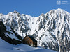
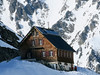

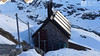
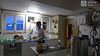
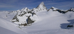
Gaulihütte is a relatively "young" mountain hut, built in 1978 in the east of the Bernese Alps an excellent location for skiing tours. Less ideal with access to the hut. The bases of skittles on Hubelhorn, Ankenbäli, Wetterhorn, Rosenhorn, Ewigschneehorn, Ränfenhorn, Hangendgletscherhorn. The last chalet on the Swiss Glacier Haute Route - an impressive crossing over the summit of Rosenhorn or Wetterhorn, with an elevation of nearly 2500 m to the Rosenlau Gorge, where writer Sir Doyle ended Sherlock Holmes life. The entrance to the hut from Innertkirchen via Urbachtal is not recommended, a safer option is from the Räterichsboden dam. An interesting fact is the fall of the American aircraft in 1947 just a few kilometers from the hut.
Tours starting from hut
Ski tours around Hut Gaulihütte

- Country
- Switzerland
- Montains
- Berner Alpen / Alpes bernoises
- Open (winter)
- mid march - end may
- Beds
- 90
- Winterraum
- open, 8 beds
- Shortening of access (cableway, lift, taxi, snowcat...)
- no
- Luggage transport
- no
- Card Pay
- no
- Shower
- no
- Wifi
- no
- UTM / CH1903 x ("longitude" E/W)
- 659580
- UTM / CH1903 y ("latitude" N/S)
- 163910
- Map
- Sustenpass 255 S, Swisstopo 1:50000 Guttannen 1230, Swisstopo 1:25000
- Guides
- Skitouren Berner Alpen Ost Die klassischen Skitouren (SAC, deutsch) Les classiques de randonnée à ski (SAC, francais) Scialpinismo in Svizzera
- Phone (hut)
- +41(0)339713166
- Phone (valley)
- -
- Cell phone
- -
- Mobile Signal
- no
- Web
- www.gaulihuette.ch
- info@gaulihuette.ch
- Owner of hut
- SAC Bern
- Gaulihütte
- Start Point
- Räterichsboden
- UTM / CH1903 x ("longitude" E/W)
- 667703
- UTM / CH1903 y ("latitude" N/S)
- 160330
- Altitude
- 1710 m
- Ascent (height difference)
- - m
- Time of Access
- 6-8 h
- Shortening lift
- no
- Avalanche danger
- SLF
- Weather
- SRF Meteo Meteoschweiz snow-forecast.com - Grindelwald Meteoblue - Gwächte yr.no - Rosenlaui Meteoblue - Ankenbälli
- Snow report
- snow-forecast.com - Grindelwald snow-forecast.com - Melchsee-Frutt bergfex.ch - Grindelwald onthesnow.com - Grindelwald myswitzerland.com -Meiringen Hasliberg
- Webcams
- Innertkirchen Guttannen Räterichsboden
- Region
- Haslital Zentralschweiz Tourismus
- Public traffic
- Vlaky Linkové autobusy
- Skiresort nearby
- Andermatt - Realp Melchsee-Frutt Grindelwald
- Other links
- Guttannen Haslital Hütten
hut Gaulihütte - Reviews
There are no reviews in this section yet. Click the Add Review button to add first review.
Best ski tours in mountains Berner Alpen / Alpes bernoises, Switzerland
-
Vorderes Galmihorn 3507 m
Oberaarjochhütte Berner Alpen / Alpes bernoises Switzerland
- Length of ascent2,5 km
- ascent760 m
- duration4,5-6,5 h
- Fitness difficulty ♦♦◊◊
- Technical difficulty ♦♦♦◊
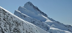
Vorderes Galmihorn je skvělý skialpový vrchol na závěr akce v centru Bernských Alp. Po výstupu na vrchol z chaty Oberaletschhütte přináší skvělou možnost sjezdu do údolí Goms, což je logisticky výhodné v případě startu lanovkou z Fiesch. Výstup vede po mírném ledovci Galmigletscher a dále po přehledném svahu posetém trhlinami. Při sjezdu dávejte pozor na trhlinu pod sedlem Bächlilicke. Na jaře vás v závěru túry nemine pochod do údolí s lyžemi na batohu. Nabízí se sjezd do Reckingenu nebo Münsteru.

-

Äbeni Flue - Ebnerfluh 3962 m
Hollandiahütte (Lötschenhütte) Berner Alpen / Alpes bernoises Switzerland
- Length of ascent4,5 km
- ascent800 m
- duration3,5-5 h
- Fitness difficulty ♦♦◊◊
- Technical difficulty ♦♦◊◊
Relatively easy glacier ski tour to the most popular summit of the Hollandia hut. The glacier is not too cracked and the ascent path is gradually gaining altitude. At the end, ridge is waiting between the secondary and main summits. With good visibility it is a ski tour without complications.
-
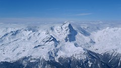
Finsteraarhorn 4374 m
Finsteraarhornhütte Berner Alpen / Alpes bernoises Switzerland
- Length of ascent3,5 km
- ascent1280 m
- duration7-9,5 h
- Fitness difficulty ♦♦♦◊
- Technical difficulty ♦♦♦♦
Na vrchol Finsteraarhorn míří náročná ledovcová túra z chaty Finsteraarhornhütte. Hned od začátku túry jsou cestou velkolepé výhledy. Náročnější je překonání skalního žebra. Po ledovci do sedla Hugisattel s leteckým pohledem na východní stěnu. Zde je skidepot a dál v mačkách a s cepínem na skialpové poměry náročným terénem. Obtížnost lezení zásadně ovlivňuje množství a konzistence sněhu na skále. Náročný sjezd prudkými svahy kopíruje linii výstupu.
Best ski tours in Switzerland by skitour.guru
-

Piz Bernina 4048 m
Chamanna Boval / Bovalhütte Bernina Alps Switzerland
- Length of ascent7,5 km
- ascent1695 m
- duration8-10,5 h
- Fitness difficulty ♦♦♦♦
- Technical difficulty ♦♦♦♦
Piz Bernina is the only 4000m peak in the Eastern Alps. The greatest danger are the huge and numerous crevasses on the Morteratsch Glacier and the ridge to the summit. Piz Bernina sets off from Chamanna Boval or Rifugio Marco e Rosa on the plateau below the summit. Bernina is a demanding alpine challenge.
-

Isentällispitz 2985 m
Davos Albula Alps Switzerland
- Length of ascent4 km
- ascent1050 m
- duration3-4,5 h
- Fitness difficulty ♦♦◊◊
- Technical difficulty ♦♦◊◊
Isentällispitz is another enjoyable ski tour starting in the Flüelatal valley. From the Tschuggen parking lot, ascend over wide slopes to the saddle, where the ski depot is located. From there, continue with crampons to the panoramic summit. The descent follows the ascent route.
-
Piz Platta 3392 m
Mulegns - Posthotel Löwen Platta Group / Oberhalbstein Switzerland
- Length of ascent11 km
- ascent1980 m
- duration8-11 h
- Fitness difficulty ♦♦♦♦
- Technical difficulty ♦♦♦◊
Impressive very long ski tour on the more pronounced Piz Platta summit in the Plattagruppe-Oberhalbstein mountain group. Aproach from the village of Mulengs - road from Tiefencastel to Julierpass. First a few kilometers through the forest, then left at the foot of the mountain and then constantly up the northeast slope to the plateau (ski depot). Next you have to climb the southern slope to the top plateau with crampons and ice axe.