
 Česky
Česky Deutsch


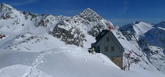


The Hildesheimer Hütte is a mountain hut near the Stubai Glacier ski area. It can be reached via a ridge from the upper station of the Jochdohle cable car. Beware of exposed areas on this route! The house is maintenance-free in winter, only winter room is available. Take the steep descent from the Hildesheimer Hütte (watch out for the risk of avalanches) and continue climbing towards Zuckerhütl.
Tours starting from hut
Ski tours around Hut Hildesheimer Hütte
-
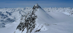
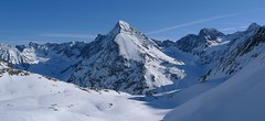
Zuckerhütl (from Hildesheimer Hütte) 3505 m
Hildesheimer Hütte Stubai Alps Austria
- Length of ascent4,5 km
- ascent700 m
- duration4-5,5 h
- Fitness difficulty ♦♦◊◊
- Technical difficulty ♦♦♦◊
Zuckerhütl je lákavým cílem z winterraumu chaty Hildesheimer Hütte. Prudký sjezd svahu od chaty na dno karu má velký lavinový potenciál a proto vyžaduje dodržování všech bezpečnostních opatření. Ze dna karu (2750 m) do sedla Pfaffenjoch a po plochém ledovci pod vrcholovou část. Tady je skidepot dále snadným lezeckým terénem v mačkách a s cepínem na vrchol. Pro sjezd existují dvě možnosti. Buď po trase výstupu zpět na chatu nebo po ledovci Sulzenauferner do údolí Stubaital. Na ledovci dávejte velký pozor na četné ledovcové trhliny.

-

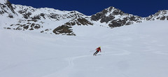
Wilder Pfaff (from Hildesheimer Hütte) 3458 m
Hildesheimer Hütte Stubai Alps Austria
- Length of ascent4,5 km
- ascent700 m
- duration3-4,5 h
- Fitness difficulty ♦♦◊◊
- Technical difficulty ♦♦♦◊
Wilder Pfaff a Zuckerhütl je lákavými cíli z winterraumu chaty Hildesheimer Hütte. Prudký sjezd svahu od chaty na dno karu má velký lavinový potenciál a proto vyžaduje dodržování všech bezpečnostních opatření. Ze dna karu (2750 m) do sedla Pfaffenjoch a po plochém ledovci pod vrcholovou část.Ke kříži je většinou možné vyšlapat na lyžích. Pro sjezd existují dvě možnosti. Buď po trase výstupu zpět na chatu nebo po ledovci Sulzenauferner do údolí Stubaital. Na ledovci dávejte velký pozor na četné ledovcové trhliny.
- Country
- Austria
- Montains
- Stubai Alps
- Open (winter)
- not guarded, winter room only
- Beds
- 0
- Winterraum
- open, 14 beds
- Shortening of access (cableway, lift, taxi, snowcat...)
- yes, cableways from Mutterbergalm to Schaufeljoch
- Luggage transport
- no
- Card Pay
- no
- Shower
- no
- Wifi
- no
- UTM / CH1903 x ("longitude" E/W)
- 32T 661199
- UTM / CH1903 y ("latitude" N/S)
- 5203572
- GPX access to hut (waipoints, track)
- Hildesheimer-Hut_access_skitour.gpx
- GPX access to hut (track only)
- Hildesheimer-Hut_access_TRK.gpx
- Map
- Stubaier Alpen - Hochstubai, OEAV 31/1 mit Skirouten , 1:25000
- Guides
- Skitourenführer Tirol Schitouren-Atlas ÖSTERREICH WEST Skitourenführer Stubaier Alpen - Panico Alpinverlag
- Phone (hut)
- -
- Phone (valley)
- +43 5254 2090
- Cell phone
- -
- Mobile Signal
- yes
- Web
- hildesheimerhuette.at
- info@gustl-soelden.com
- Owner of hut
- DAV Sektion Hildesheim
- Hildesheimer Hütte
- Start Point
- Schaufeljoch - Stubaier Gletscher skiarea
- UTM / CH1903 x ("longitude" E/W)
- 32T 660349
- UTM / CH1903 y ("latitude" N/S)
- 5204796
- Altitude
- 3135 m
- Ascent (height difference)
- -280 m (walking), 1,6 km m
- Time of Access
- 1-1,5 h
- Shortening lift
- yes, cableways from Mutterbergalm to Schaufeljoch
- Start Point
- Mutterbergalm - Stubaital, parking
- UTM / CH1903 x ("longitude" E/W)
- 32T 663682
- UTM / CH1903 y ("latitude" N/S)
- 5208536
- Altitude
- 1750 m
- Ascent (height difference)
- 1400 m
- Time of Access
- 4-5 h
- Shortening lift
- yes, cableways of Stubaier Gletscher
- Avalanche danger
- LWD Tirol
- Weather
- Hildesheimer Hütte - meteoblue.com Stubaier Gletscher - snow-forecast.com Stubaier Wildspitze 3341 - meteoblue.com Zuckerhütl - mountain-forecast.com ORF ZAMG Alpenverein.at
- Snow report
- Stubaier Gletscher - bergfex.at Stubaier Gletscher, onthesnow.com Stubaier Gletscher, snow-forecast.com Stubaier Gletscher, snow.cz
- Webcams
- Stubai Gletscher - all webcams
- Region
- Stubai Tirol
- Public traffic
- Postbus ÖBB Railway
- Skiresort nearby
- Stubaier Gletscher
- Other links
- Austria Tourism
hut Hildesheimer Hütte - Reviews
There are no reviews in this section yet. Click the Add Review button to add first review.
Best ski tours in mountains Stubai Alps, Austria
-

Östliche Seespitze 3416 m
Franz Senn Hütte Stubai Alps Austria
- Length of ascent6,5 km
- ascent1270 m
- duration6-8 h
- Fitness difficulty ♦♦♦◊
- Technical difficulty ♦♦♦◊
Östliche Seespitze (Franz Senn Hütte, Stubaier Alpen) is a glacier tour with a steep passage (30-35°). At the end without skiing along the ridge to the summit.
-
Ruderhofspize S (from Stubai Valley) 3473 m
Stubai - Mutterbergalm (cable car) Stubai Alps Austria
- Length of ascent6,5 km
- ascent1770 m
- duration5,5-7 h
- Fitness difficulty ♦♦♦◊
- Technical difficulty ♦♦◊◊
Ruderhofspitze je velkolepá túra širokým jižním svahem, až poslední desítky metrů se musí jít bez lyží. Sjezd po trase výstupu je víceméně příjemného sklonu, většinou mezi 20-25 stupni a hlavně na jarním firnu to je velkolepé svezení.
-
Schrankogel 3497 m
Amberger Hütte Stubai Alps Austria
- Length of ascent6,5 km
- ascent1300 m
- duration4-6 h
- Fitness difficulty ♦♦♦◊
- Technical difficulty ♦♦♦♦
Schrankogel je impozantní vrchol Stubaiských Alp v oblasti Amberger Hütte. Poměrně snadný nástup na úpatí, odtud na mačkách po místy exponovaném hřebenu na vrchol.
Best ski tours in Austria by skitour.guru
-

Festkogel 2269 m
Johnsbach - Kölblwirt Gesäuse Austria
- Length of ascent5,5 km
- ascent1430 m
- duration6-8 h
- Fitness difficulty ♦♦♦◊
- Technical difficulty ♦♦♦◊
Festkogel is a very attractive ski tour between the rocks with a breathtaking view of the whole Gesäuse and the Enns valley. From the parking (of the Hesshütte), nearby the restaurant and Hotel Kölblwirt towards the waterfall along the trail. Continue through a steep narrow rock ditch towards the tower Schneekarturm. Around the tower until the last part of the climb. By frequent crossing of steep slopes, the Festkogel is recommended a ski trip in stable conditions.
-

Stubacher Sonnblick 3088 m
Rudolfshütte Berghotel Granatspitz Group - Hohe Tauern Austria
- Length of ascent5 km
- ascent920 m
- duration3-4,5 h
- Fitness difficulty ♦♦◊◊
- Technical difficulty ♦♦◊◊
Stubacher Sonnblick z Rudolfshütte je sázka na jistotu. Varianta výstupové i sjezdové linie. Závěrečných 150 výškových metrů mezi ledovcem a vrcholem tvoří kamenná pyramida. Pokud jsou dobré sněhové podmínky, dá se vystoupat na lyžích až k vrcholovému kříži. Z vrcholu je krásný výhled k západu na dominantní rozložitý masiv Grossvenedigeru. Jihovýchodnímu směru jasně kraluje nejvyšší rakouská hora – Grossglockner.
-

Nockberge Trail Day 2 2336 m
Innerkrems - Mehrlhütte Nockberge Austria
- Length of ascent10,5 km
- ascent1210 m
- duration6-8 h
- Fitness difficulty ♦♦♦◊
- Technical difficulty ♦♦♦◊
2. etapa 4denního skialpového přechodu Nockberge Trail vede z Innerkremsu na Turracher Höhe a je ze všech nejnáročnější - jak délkou, převýšenm tak i technickou náročností. Oblé kopce alpského pohoří Nockberge mají jedinou nevýhodu - vítr z jejich svahů často odfoukne sníh a je ho místy nedostatek. Po bezproblémovém výstupu na Königstuhl a Karlnock následuje sjezd do sedla Stangnock a pak po širokém hřebenu nahoru na Gregerlnock. Následující sjezd poměrně prudkým svahem má lavinový potenciál - buďte pozorní, v případě špatných podmínek sjíždějte po hřebenu do míst, kde je svah mírnější. Po sjezdu na alm následuje orientačně zapeklitá fáze - držte se striktně linie v GPS. Za potokem začíná výstup na Winkler Alm. Cesta na sjezdovku nevede přes les (pozor na stopy). Až dorazíte k sjezdovce, musíte ještě vystoupat k lanovce Schafalmbahn (na dohled) a po sjezdovce č.1 na sedlo Turracher Höhe.