
 Česky
Česky Deutsch


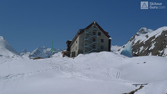


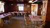


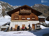
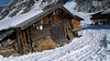
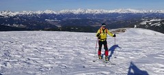
Franz Senn Hütte is traditional hut in the Stubai region, one of the largest number of tours in the Alps - Innere Sommerwand, Kraulscharte, Kraulspitze, Östliche Seespitze, Ruderhofspitze, Wildes Hinterbergl, Wildgratscharte ... Great capacity, giant winterraum, great fruit Marschtee. And a nice service that the Fankhauser family cares for.
Tours starting from hut
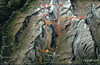
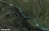
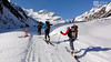
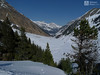
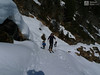
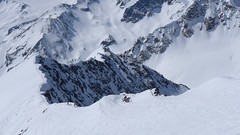
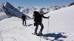
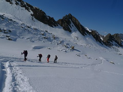
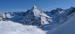
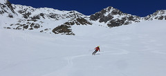
Ski tours around Hut Franz Senn Hütte
-
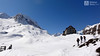
Ruderhofspitze NW (Franz Senn Hütte) 3473 m
Franz Senn Hütte Stubai Alps Austria
- Length of ascent10 km
- ascent1350 m
- duration7-9 h
- Fitness difficulty ♦♦♦◊
- Technical difficulty ♦♦♦◊
The Ruderhofspitze NW (Franz Senn Hütte, Stubaier Alpen) is a long tour of the glacier Alpeiner Ferner, which finish at the rock ridge.

-
Wildes Hinterbergl 3225 m
Franz Senn Hütte Stubai Alps Austria
- Length of ascent7 km
- ascent1141 m
- duration5-8 h
- Fitness difficulty ♦♦◊◊
- Technical difficulty ♦♦♦◊
Wildes Hinterbergl (Franz Senn Hütte, Stubaier Alpen) is the most attractive ski tour from Franz Senn Hütte. In addition, it offers two variants of the downhill. Great lookout mountain.
-

Östliche Seespitze 3416 m
Franz Senn Hütte Stubai Alps Austria
- Length of ascent6,5 km
- ascent1270 m
- duration6-8 h
- Fitness difficulty ♦♦♦◊
- Technical difficulty ♦♦♦◊
Östliche Seespitze (Franz Senn Hütte, Stubaier Alpen) is a glacier tour with a steep passage (30-35°). At the end without skiing along the ridge to the summit.
-

Innere Sommerwand 3122 m
Franz Senn Hütte Stubai Alps Austria
- Length of ascent7 km
- ascent1270 m
- duration5-7 h
- Fitness difficulty ♦♦◊◊
- Technical difficulty ♦♦◊◊
Innere Sommerwand (Franz Senn Hütte, Stubaier Alpen) is the perfect scenery for the final day of stay at Franz Senn Hütte. After leaving the Sommerwandferner Glacier and the downhill, a short ascent and a downhill ride to Oberrissalm will be enough.
-
Kraulscharte 3069 m
Franz Senn Hütte Stubai Alps Austria
- Length of ascent4,5 km
- ascent930 m
- duration4-6 h
- Fitness difficulty ♦♦◊◊
- Technical difficulty ♦♦◊◊
Kraulscharte (Franz Senn Hütte, Stubaier Alpen) is a simple acclimatization ski tour on the arrival of Franz Senn Hut.
- Country
- Austria
- Montains
- Stubai Alps
- Open (winter)
- mid februar - early may
- Beds
- 180
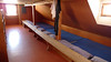
- Winterraum
- open, 12 beds
- Shortening of access (cableway, lift, taxi, snowcat...)
- luggage transport on the cableway
- Luggage transport
- yes, must be ordered
- Card Pay
- no
- Shower
- yes
- Wifi
- yes
- UTM / CH1903 x ("longitude" E/W)
- 32 T 664618
- UTM / CH1903 y ("latitude" N/S)
- 5216906
- GPX access to hut (waipoints, track)
- Franz Senn Huette ACCESStour.gpx
- GPX all tours from the hut
- Franz Senn Huette AUT STUBAI SkitourGuru.gpx
- Map
- Stubaier Alpen - Hochstubai, OEAV 31/1 mit Skirouten , 1:25000
- Guides
- Skitourenführer Tirol Schitouren-Atlas ÖSTERREICH WEST
- Phone (hut)
- +43 (0)5226 2218
- Phone (valley)
- +43 (0)664 444 2094
- Cell phone
- +43 (0)664 444 2094
- Mobile Signal
- yes, but outside the hut
- Web
- -
- office@franzsennhuette.at
- Owner of hut
- ÖAV Alpenverein Innsbruck
- Franz-Senn-Hütte
- Start Point
- Seduck (Neustift in Stubaital)
- UTM / CH1903 x ("longitude" E/W)
- 32 T 669590
- UTM / CH1903 y ("latitude" N/S)
- 5220266
- Altitude
- 1450 m
- Ascent (height difference)
- 700 m
- Time of Access
- 2-3 h
- Shortening lift
- cableway for luggage
- Avalanche danger
- LWD Tirol
- Weather
- ZAMG ORF Alpenverein.at wetter.at meteoblue.com bergfex.at yr.no - Franz Senn Hütte yr.no - Ruderhofspitze
- Snow report
- snow-forecast.com bergfex.at
- Webcams
- Franz Senn Hütte Stubai Gletscher
- Region
- Stubai Tirol
- Public traffic
- Postbus ÖBB Railway
- Skiresort nearby
- Neustift - Elferbahnen Stubaier Gletscher
- Other links
- Austria Tourism
hut Franz Senn Hütte - Reviews
There are no reviews in this section yet. Click the Add Review button to add first review.
Best ski tours in mountains Stubai Alps, Austria
-
Schrankogel 3497 m
Amberger Hütte Stubai Alps Austria
- Length of ascent6,5 km
- ascent1300 m
- duration4-6 h
- Fitness difficulty ♦♦♦◊
- Technical difficulty ♦♦♦♦
Schrankogel je impozantní vrchol Stubaiských Alp v oblasti Amberger Hütte. Poměrně snadný nástup na úpatí, odtud na mačkách po místy exponovaném hřebenu na vrchol.
-
Ruderhofspize S (from Stubai Valley) 3473 m
Stubai - Mutterbergalm (cable car) Stubai Alps Austria
- Length of ascent6,5 km
- ascent1770 m
- duration5,5-7 h
- Fitness difficulty ♦♦♦◊
- Technical difficulty ♦♦◊◊
Ruderhofspitze je velkolepá túra širokým jižním svahem, až poslední desítky metrů se musí jít bez lyží. Sjezd po trase výstupu je víceméně příjemného sklonu, většinou mezi 20-25 stupni a hlavně na jarním firnu to je velkolepé svezení.
-

Kuhscheibe 3188 m
Amberger Hütte Stubai Alps Austria
- Length of ascent5,5 km
- ascent1050 m
- duration3,5-4,5 h
- Fitness difficulty ♦♦◊◊
- Technical difficulty ♦♦◊◊
Túra na Kuhscheibe patří se středně náročným. Na vrchol se potřeba dolézt v mačkách. Krásný výhled na Ötztálské Alpy včetně střediska Sölden.
Best ski tours in Austria by skitour.guru
-

Weisskugel East, from Hochjoch Hospiz 3739 m
Hochjoch Hospiz Ötztal Alps / Alpi Venoste Austria
- Length of ascent11 km
- ascent1550 m
- duration7-10 h
- Fitness difficulty ♦♦♦♦
- Technical difficulty ♦♦♦◊
Skialpinistická túra na Weisskugel je obtížná především svou délkou. Začátek túry se liší podle sněhové situace. Když je málo sněhu, jde se po rampě, víceméně po vrstevnici k ledovci Hintereisferner. Po ledovci mírně nahoru západním směrem. Prudký je až výšvih do sedla Hintereisjoch, odkud se stoupá doprava, severním směrem k vrcholu. Poslední desítky metrů vedou exponovaným terénem, hodně záleží na množství sněhu.
-

Königstuhl 2336 m
Innerkrems - Mehrlhütte Nockberge Austria
- Length of ascent6,5 km
- ascent840 m
- duration4,5-6 h
- Fitness difficulty ♦♦◊◊
- Technical difficulty ♦♦◊◊
Skialpová túra na Königstuhl je nejlepší trasou v této oblasti, hlavně díky panoramatům na pohoří Nockberge a na Niedere Tauern (Nízké Taury). Snazší výstup vede údolím potoka Krems a výše podél jezera Rosaninsee do sedla Königstuhlscharte. Odtud po plochém západním svahu na vrchol. Sjezd po trase výstupu. Za příznivé lavinové situace je mnohem atraktivnější panoramatická hřebenovka přes Sauereggnock, Vogelsangberg a Seenock. Pozor, místy s exponovanými úseky. Pokud je dobrý sníh, sjeďte z vrcholu Seenock do kotle k jezeru a pokračujte na pásech do sedla a na vrchol. Uvedené údaje platí pro okružní hřebenovou variantu.
-
Nockberge Trail Day 1 2214 m
Katschberghöhe Nockberge Austria
- Length of ascent8,5 km
- ascent1060 m
- duration6-8 h
- Fitness difficulty ♦♦♦◊
- Technical difficulty ♦♦◊◊
Nockberge Trail je panoramacká 4 denní skialpinistická trasa v korutanském pohoří Nockberge. 1. etapa začíná výjezdem lanovkou z Katschbergu na vrchol Ainecku (když je silný vítr, lanovka nejede a je potřeba vystoupat na pásech). Ze sjezdovky na svahy hory Teuerlnock. Hezký mírný sjezd směrem k Bonnerhütte (zavřená). Následuje výstup na alm a kvěma serpentinami dolů (pásy se nevyplatí sundávat). Na lavičce u chaty Lausnitzalm svačinka. Nad východním břehem jezera Lausnitrealm vstup na náhorní plošinu a střídání nahorů - dolů, na pásech. Z vrcholu Gaipahöhe buď sjezd do Innerkrems (hotely) nebo stále vrchem přes sjezdovky skiresortu na východ a sjez na chatu Dr.-Joseh-Mehrl-Hütte. Orientačně náročná trasa, raději s GPS navigací