
 Česky
Česky Deutsch


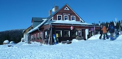


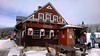


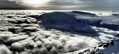
Děčínská bouda is not far below the intermediate station Růžová hora on the Pec - Sněžka cable car route. Classic cozy holiday home with excellent cuisine and costumed service. Last night on the Haute Route from Krkonoše.
Tours starting from hut
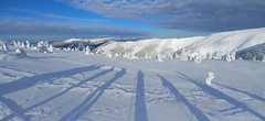
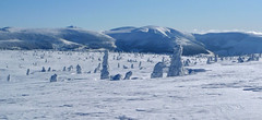
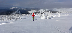
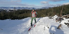
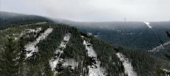
Ski tours around Hut Děčínská bouda - Růžohorky
-
Krkonoše haute route, day 4 1360 m
Děčínská bouda - Růžohorky Giant Mountains Czech
- Length of ascent5 km
- ascent620 m
- duration4-5,5 h
- Fitness difficulty ♦◊◊◊
- Technical difficulty ♦♦◊◊
The last, 4th day of the Krkonoše Haute Route begins with a short ascent to Růžová hora. This is followed by a freeride under the rope to Pec pod Sněžkou. From the lower station of the Pec-Sněžka cable car up around the mountain hut Richtrovy Boudy to Výrovka. The last descent through the Dlouhý důl valley to Špindlerův Mlýn.

-

Sněžka - Portášky 1603 m
Děčínská bouda - Růžohorky Giant Mountains Czech
- Length of ascent6,5 km
- ascent1100 m
- duration5-7 h
- Fitness difficulty ♦♦◊◊
- Technical difficulty ♦♦◊◊
Na Sněžku se dá vyrazit nejen z Pece p. Sněžkou, ale také z Velké Úpy. Výstup ulehčí lanovka na Portášky. Dále k Děčínské boudě a pak rozhodování. Buď podél lanovky a Sněžku nebo sjezd do Pece a na Sněžku Obřím dolem.
- Country
- Czech
- Montains
- Giant Mountains
- Open (winter)
- daily
- Beds
- 21
- Winterraum
- no
- Shortening of access (cableway, lift, taxi, snowcat...)
- yes, by cableway from Pec pod Sněžkou to Růžová hora
- Luggage transport
- yes, by cable car
- Card Pay
- no
- Shower
- yes
- Wifi
- yes
- UTM / CH1903 x ("longitude" E/W)
- 33U 552923
- UTM / CH1903 y ("latitude" N/S)
- 5617898
- GPX all tours from the hut
- Decinska-bouda_all_WPT_TRK.gpx
- Map
- Krkonoše střed, zimní mapa 1:25 000, ROSY Krkonoše východ, zimní mapa 1:25 000, ROSY
- find current conditions and experiences on the spot
- Skialp/freeride Krkonoše
- Phone (hut)
- +420 733 557 999
- Phone (valley)
- -
- Cell phone
- -
- Mobile Signal
- yes
- Web
- -
- horskafarma@email.cz
- Owner of hut
- privat
- Bouda Pod Sněžkou
- Reservation
- online form
- Online reservation
- ceskehory.cz
- Avalanche danger
- horskasluzba.cz
- Weather
- Pec pod Sněžkou, ventusky.com Sněžka 1602 m, meteoblue.com Sněžka 1602 m, mountain-forecast.com Pec pod Sněžkou, horskasluzba.cz Pec pod Sněžkou, in-pocasi.cz Pec pod Sněžkou, meteoskop.cz Pec pod Sněžkou, ceskehory.cz ČHMU - model Aladin Pec pod Sněžkou, snow-forecast.com Pec pod Sněžkou, snow.cz
- Snow report
- Pec pod Sněžkou, snow-forecast.com Pec pod Sněžkou, snow.cz Pec pod Sněžkou, onthesnow.com Pec pod Sněžkou, bergfex.com
- Webcams
- Bouda Pod Sněžkou Pec pod Sněžkou, bergfex.com Pec pod Sněžkou, holidayinfo.cz
- Region
- krkonose.eu Pec pod Sněžkou - tourist information Czech Tourism - Kudy z nudy
- Public traffic
- České dráhy - train IDOS - timetables
- Skiresort nearby
- Pec pod Sněžkou
hut Děčínská bouda - Růžohorky - Reviews
There are no reviews in this section yet. Click the Add Review button to add first review.
Best ski tours in mountains Giant Mountains, Czech
-
Kotel - Rokytnice nad Jizerou 1435 m
Rokytnice n.J. - Dvoračky Giant Mountains Czech
- Length of ascent8 km
- ascent730 m
- duration3-4,5 h
- Fitness difficulty ♦◊◊◊
- Technical difficulty ♦◊◊◊
Okruh po hřebenech Krakonoš nad Rokytnicí je nejlépe dostupný z horského hotelu Dvoračky - Štumpovka. Okruh začíná sjezdem na Lovčenku a pak na pásech 400 výškových metrů. Další orientační bod je Zadní Plech. Následuje dlouhý výstup na hřeben, odkud je možná odbočka na Labskou boudu. Po hřebenové cestě kolem oblého vrcholu Kotel a Lysou horou na Dvoračky.
-
Krkonoše haute route, day 3 1603 m
Bouda pod Sněžkou Giant Mountains Czech
- Length of ascent4 km
- ascent800 m
- duration3-4,5 h
- Fitness difficulty ♦♦◊◊
- Technical difficulty ♦♦◊◊
Sněžka je nejvyšší česká hora. Nejzajímavější trasa vede z Obřího dolu od Boudy pod Sněžkou. Lze podniknout okružní túru se sjezdem podél lanovky Pec - Sněžka k mezistanici Růžová hora. O něco níže je dvojice horských chat - Děčínská bouda a Růžohorky. Zde končí 3. etapa Krkonošské haute route.
-
Dlouhý důl 1360 m
Chata Výrovka Giant Mountains Czech
- Length of ascent9 km
- ascent840 m
- duration3-5 h
- Fitness difficulty ♦♦◊◊
- Technical difficulty ♦◊◊◊
The ski tour begins in the Svatý Petr ski resort at the lower station of the Pláně cable car. A simple gradual ascent interrupts the crossing of the Stoh ski slope. Crampons can be useful on the icy surface of the steep north slope. Soon a couple of switchbacks and possibly a short descent to Bouda Klínovka. Chalupa na Rozcestí and Výrovka offer further refreshment options. A descent leads from Výrovka through the Dlouhý důl valley to Špindlerův Mlýn.
Best ski tours in Czech by skitour.guru
-
Okolo Vsackého Cábu 830 m
Javorníky - Valašsko Javorníky - Valašsko Czech
- Length of ascent5 km
- ascent320 m
- duration1,5-2,5 h
- Fitness difficulty ♦◊◊◊
- Technical difficulty ♦◊◊◊
Zajímavosti na trase: Horský hotel Vsacký Cáb (jedna z prvních horských chat KČT v Beskydech 1927-28). Cábské jezírko (vzniklo při sesuvu, který přehradil jeden z přítoků Malé Bystřičky). Vyhlídka na vrcholu sjezdovky na Vsackém Cábu. Z parkoviště u Horského hotelu Vsacký Cáb se vydáme po červené turistické značce směrem na rozcestí Ptáčnice. Zde odbočíme doleva a po žluté značce. Po jednom kilometru odbočíme z hřebene na Baťovu NS směrem k Cábskému jezeru. Zpáteční cesta od jezera vede po stejné trase zpět na žlutou značku. Po ní jdeme cca 300 metrů a odbočíme na trasu běžecké zimní trasy. Po ní se vrátíme zpět k chatě na Cábu a ještě než u ní ukončíme skitouringovou trasu, vyjdeme nad hotelem na vrcholek sjezdovky. Tu sjedeme a vrátíme se zpět k chatě.
-

Klínovec - Boží Dar - okruh 1244 m
Boží Dar - Klínovec Krušné hory Czech
- Length of ascent7,5 km
- ascent580 m
- duration3-3,5 h
- Fitness difficulty ♦◊◊◊
- Technical difficulty ♦◊◊◊
-
Macecha 1113 m
Boží Dar - Klínovec Krušné hory Czech
- Length of ascent4,5 km
- ascent300 m
- duration2-2,5 h
- Fitness difficulty ♦◊◊◊
- Technical difficulty ♦◊◊◊