
 Česky
Česky Deutsch


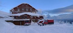


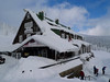

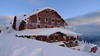


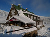
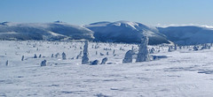
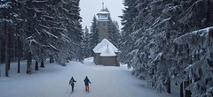
The two huts - Dvoračky and Štumpovka are next to each other and have one owner. The location of the holiday home under the ridge, not far from the cable car to Lysá hora, is an excellent starting point for ski tours to the Giant Mountains ridge. The easiest access is from Rokytnice nad Jizerou by cable car to Lysá hora and from there a short descent to the mountain hut.
Tours starting from hut
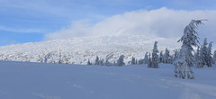
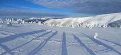
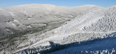
Ski tours around Hut Rokytnice n.J. - Dvoračky
-
Kotel - Rokytnice nad Jizerou 1435 m
Rokytnice n.J. - Dvoračky Giant Mountains Czech
- Length of ascent8 km
- ascent730 m
- duration3-4,5 h
- Fitness difficulty ♦◊◊◊
- Technical difficulty ♦◊◊◊
Okruh po hřebenech Krakonoš nad Rokytnicí je nejlépe dostupný z horského hotelu Dvoračky - Štumpovka. Okruh začíná sjezdem na Lovčenku a pak na pásech 400 výškových metrů. Další orientační bod je Zadní Plech. Následuje dlouhý výstup na hřeben, odkud je možná odbočka na Labskou boudu. Po hřebenové cestě kolem oblého vrcholu Kotel a Lysou horou na Dvoračky.

-

Vlčí hřeben 1130 m
Rokytnice n.J. - Dvoračky Giant Mountains Czech
- Length of ascent6,5 km
- ascent380 m
- duration2,5-4,5 h
- Fitness difficulty ♦◊◊◊
- Technical difficulty ♦◊◊◊
Velice lehký okruh pro absolutní začátečníky, ideální pro malé děti. V polovině trasy nabízí občerstvení Hotel Rezek.
- Country
- Czech
- Montains
- Giant Mountains
- Open (winter)
- daily
- Beds
- 141
- Winterraum
- no
- Shortening of access (cableway, lift, taxi, snowcat...)
- by cableway, from Rokytnice to Lysá hora
- Luggage transport
- yes
- Shower
- yes
- Wifi
- yes
- UTM / CH1903 x ("longitude" E/W)
- 33U 536098
- UTM / CH1903 y ("latitude" N/S)
- 5621858
- GPX all tours from the hut
- Dvoracky-Rokytnice_all_WPT_TRK.gpx
- Map
- Krkonoše západ, zimní mapa 1:25 000, ROSY
- Phone (hut)
- +420 720 983 033
- Phone (valley)
- -
- Cell phone
- -
- Mobile Signal
- yes
- Web
- dvoracky.cz
- info@dvoracky.cz
- Owner of hut
- privat
- Dvoračky Štumpovka
- Reservation
- online form
- Online reservation
- https://www.dvoracky.cz/
- Avalanche danger
- horskasluzba.cz
- Weather
- Rokytnice, ventusky.com Lysá hora 1344m, meteoblue.com Rokytnice, horskasluzba.cz Zadní Plech 1210m, meteoblue.com Rokytnice, in-pocasi.cz Rokytnice, meteoskop.cz Rokytnice, ceskehory.cz ČHMU - model Aladin Rokytnice, snow-forecast.com
- Snow report
- Rokytnice, snow-forecast.com Rokytnice, snow.cz Rokytnice, onthesnow.com Rokytnice, bergfex.com
- Webcams
- Rokytnice.com bergfex.com holidayinfo.cz
- Region
- krkonose.eu rokytnice.com - tourist information Czech Tourism - Kudy z nudy
- Public traffic
- České dráhy - train IDOS - timetables
- Skiresort nearby
- Rokytnice nad Jizerou
hut Rokytnice n.J. - Dvoračky - Reviews
There are no reviews in this section yet. Click the Add Review button to add first review.
Best ski tours in mountains Giant Mountains, Czech
-
Krakonoš - Bílé Labe 1422 m
Špindlerův Mlýn Giant Mountains Czech
- Length of ascent8 km
- ascent800 m
- duration3-4,5 h
- Fitness difficulty ♦◊◊◊
- Technical difficulty ♦◊◊◊
Jednoduchá skialpová túra ze Špindlerova Mlýna začíná na parkovišti pod sjezdovkou Stoh. Výstup míří k vyhlídkovému bodu Krakonoš a dále po pláni na Luční boudu. Sjezd údolím Bílého Labe.
-

Krkonoše haute route, day 1 1509 m
Špindlerův Mlýn Giant Mountains Czech
- Length of ascent17 km
- ascent1470 m
- duration6-9 h
- Fitness difficulty ♦♦♦◊
- Technical difficulty ♦♦◊◊
The ski mountaineering crossing of the highest Czech mountains, the Giant Mountains, begins in Špinlerův Mlýn. Via Horní Mísečky and the edge of Kotelní jáma you climb to Dvoračky and further along the ridge to Labská bouda. The highlight of the tour is the ascent to Vysoké kolo and the subsequent descent to Martinova bouda or Brádlerovy boudy.
-
Krkonoše haute route, day 4 1360 m
Děčínská bouda - Růžohorky Giant Mountains Czech
- Length of ascent5 km
- ascent620 m
- duration4-5,5 h
- Fitness difficulty ♦◊◊◊
- Technical difficulty ♦♦◊◊
The last, 4th day of the Krkonoše Haute Route begins with a short ascent to Růžová hora. This is followed by a freeride under the rope to Pec pod Sněžkou. From the lower station of the Pec-Sněžka cable car up around the mountain hut Richtrovy Boudy to Výrovka. The last descent through the Dlouhý důl valley to Špindlerův Mlýn.
Best ski tours in Czech by skitour.guru
-
Sestupová, trasa"D", Dolní Morava 1232 m
Slaměnka - Dolní Morava Jeseniky Czech
- Length of ascent6 km
- ascent540 m
- duration2,5-3,5 h
- Fitness difficulty ♦◊◊◊
- Technical difficulty ♦◊◊◊
Trasy pro fitness skitouring nebo skitouring pro začátečníky na Dolní Moravě jsou vyznačeny, vedou po lesních přístupových cestách v blízkosti sjezdovek, část souběžně s běžeckými trasami a značenými turistickými chodníky. Na těchto trasách nepotřebujete lavinovou výbavu. Potřebné vybavení si můžete půjčit ve Skitourcentum u parkoviště na Točně nebo v půjčovně střediska DM naproti hotelu Vista. Skialpová trasa "D" slouží hlavně pro jízdu dolů z vrcholu Slamník. Dá se využít i pro výstup, hlavně ve středu a v pátek, a to i do pozdního večera při čelovce. Vede od Skitourcentra podél silnice k hotelu Vista, dále pak cestou k bývalému lomu. Od něj vpravo lesní cestou až k horní stanici lanovky U Slona – Vyhlídka. Dále pak stejně jako trasou A. Přes rozcestí u Chlumu kolem Slaměnky na Slamník. Na této trase dbejte zvýšené opatrnosti při dvojitém přecházení sjezdových tratí skiareálu, hlavně při jízdě dolů, kdy může být na sjezdových tratích pracující rolba. Všechny trasy na DM se dají zakončit u horské chaty Slaměnka pod vrcholem Slamníku. Sjezd do údolí je po sjezdovkách střediska, které jsou po 16 h. zavřené. V případě večerního sjezdu pozor na nebezpečí ocelového lana, na kterém je zavěšena rolba upravující svah. Lano představuje smrtelné nebezpečí!
-
Kozubová 981 m
Moravskoslezské Beskydy Beskydy Czech
- Length of ascent5 km
- ascent490 m
- duration2,5-3 h
- Fitness difficulty ♦◊◊◊
- Technical difficulty ♦◊◊◊
-
Ještěd - trasa Frantina 925 m
Ještěd - Jizerské hory Jizera Mountains Czech
- Length of ascent4 km
- ascent565 m
- duration h
- Fitness difficulty ♦◊◊◊
- Technical difficulty ♦◊◊◊
Delší trasa po svazích Ještědu z Horního Hanychova přes chatu KČT Pláně pod Ještědem (výstavka z historie Horské služby Jizerky) pod Černý vrch a odtud sjezd na Skalku.