
 Česky
Česky Deutsch


 Dolomiti Italy photo 01")
 Dolomiti Italy photo 02")
 Dolomiti Italy photo 03")
 Dolomiti Italy photo 04")
 Dolomiti Italy photo 05")
 Dolomiti Italy photo 06")
 Dolomiti Italy photo 07")
 Dolomiti Italy photo 08")
 Dolomiti Italy photo 09")
 Dolomiti Italy photo 10")
 Dolomiti Italy photo 11")
 Dolomiti Italy photo 12")
 Dolomiti Italy photo 13")
 Dolomiti Italy photo 14")
 Dolomiti Italy photo 15")
 Dolomiti Italy photo 16")
 Dolomiti Italy photo 17")


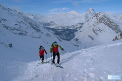
Tre Cime / Drei Zinnen are the monumental three limestone towers - the symbol of the Sexten Dolomites. The saddle between the central and the western tower can be built in great conditions on skis and on the northern slope under the excellent conditions. Spectacular adrenaline action!
Peak
- Country
- Italy
- Montains
- Dolomiti
- Tags
- Dolomiti Haute Route Dolomits South Tyrol Italy Sexten Sextener Dolomiten
- Hut
- Sextner Dolomiten / Dolomiti Sesto - Dolomitenhof
- UTM / CH1903 x ("longitude" E/W)
- 33 T 292889
- UTM / CH1903 y ("latitude" N/S)
- 5166206
Start point
- Start Point
- Rif. Lago Antorno
- Altitude
- 1880 m
- UTM / CH1903 x ("longitude" E/W)
- 33 T 290426
- UTM / CH1903 y ("latitude" N/S)
- 5163695
- village, valley
- Lago Misurina, Schluderbach - Lago Landro
- cableway / lift
- no, by car
Conditions
- Avalanche danger
- Südtirol Lawinenlagebericht (it, de)
- Weather
- Südtirol Wetterbericht (it, de) Sexten / snow-forecast.com Sexten / meteo.it (it) Sexten / meteoam.it (it) Sexten / yr.no Ostalpen / alpenverein.at (de) Meteodata (Berg) Elferkofel 3090m / mountain-forecast.com Dreischusterspitze, Cima Tre Scarperi 3151m / mountain-forecast.com
- Snow report
- Sexten / bergfex.it Sexten / snow-forecast.com Sexten / schneeradar.de (de) Sexten / onthesnow.com (en)
- Webcams
- Sexten - Drei Zinnen Blick Sexten Helm Drei Zinnen Hütte Fischleintal
Ski tour map on Tre Cime / Drei Zinnen (Day 5 H.R. Dolomiten)


 bivakovací nouzová chata
  cepín a mačky potřeba
 exponovaný, obtížný terén
 horská chata
 hôtel, penzion
 lanovka, vlek
 lavinové nebezpečí, svah > 30°
 ledovcové trhliny
 lehká túra
 mimořádně obtížná túra
 mírně obtížná túra
 obtížná túra
 parkoviště
 přístup k chatě
 restaurace
 sedlo
sedlo sjezd
sjezd skidepo
 vrchol
 výstup
 začátek ledovce
- bivouac, winter room
- crampons & ice axe necessary
- exposed, difficulty terrain
- mountain hut, refuge
- hotel, pension
- cableway, skilift
- avalanche danger, slope > 30°
- glacier cracks
- little difficult tour
- extremely difficult tour
- rather difficult tour
- difficult tour
- parking
- hut acces
- restaurant
- col, pass, saddle
- descent
- skidepot
- peak, summit
- ascent
- glacier beginning
- biwak, winterraum
- steigeisen & pickel erforderlich
- ausgesetzt, schwierige gelände
- berghütte
- hotel, pension
- seilbahn, skilift
- lawinengefahr, hangneigung > 30°
- gletscherspalten
- wenig schwierige tour
- äusserst schwierige tour
- ziemlich schwierige tour
- schwierige tour
- parkplatz
- zugang zur hütte
- restaurant
- sattel, joch, pass
- abfahrt
- skidepot
- gipfel
- aufsieg
- gletscher anfang
- bivacco, locale invernale
- ramponi & piccozza necessari
- esposto, terreno difficolt?
- rifugio, capanna
- alberghi, pensione
- funivia, seggiovia
- pericolo di valanghe, pendenza > 30°
- crepe glacier
- tour piccolo difficile
- tour estremamente difficile
- tour piuttosto difficile
- escursioni difficili
- parcheggio
- accesso capanna
- ristorante
- col, sella, passo, forcella
- discesa
- sci deposito
- picco, vertice, piz
- salita
- inizio ghiacciaio
- bivouac, local d'hiver
- crampons & piolet nécessaire
- exposée, difficulté du terrain
- cabane de montagne, refuge
- hôtel, pension
- téléphérique, téléski
- danger d'avalanche, pente > 30°
- crevasse du glacier
- peu difficile tour
- extr?mement difficile tournée
- assez difficile tour
- difficile tournée
- parking
- acces cabane
- restaurant
- col, selle
- descente
- skis dépôt
- pic, sommet
- ascension
- début glacier
- < 20°
- 20° - 25°
- 25° - 30°
- 30° - 35°
- 35° - 40°
- > 40°
Current weather conditions in the tour area
Planning of ski tour
- Fitness difficulty
-
- ♦♦♦◊
- Technical difficulty
-
- ♦♦♦♦
- best time for this tour
- March-April
- Glacier
- No
- Map
- Sextener Dolomiten, Tabacco Nr. 10, 1:25000
- Guides
- Skitouren in Dolomiten (de, it - Tappeiner)
About Ski tour
- Time difficulty
- Ascent (height difference)
- 1250 m
- Lenght of ascent
- 9 km
- Descent (height difference)
- 1280 m
- Total Lenght of tour
- 16,5 km
- Total time of the tour
- 5-7 h
- Elevation Range
- 1460 - 2740 m
- Principal Aspect
- N, S S-south, N-north, W-west, E-east
Download
- GPX (track only)
- DolomitiHR_5d_TrCime_allTRK.gpx best for display on a detailed topographical map (mapy.cz) or in apps for smartphones (Locus, Garmin Connect, etc.)
- GPX (waipoints, track)
- DolomitiHR_5d_TreCime.gpx great for uploading in GPS device
- KML (with POI)
- DolomitiHR_5d_Drei_Zinnen_all_wpt_icons_TOUR.kml for viewing in the Google Earth 3D map application, which you can install on your PC
tour Tre Cime / Drei Zinnen (Day 5 H.R. Dolomiten) - Reviews
There are no reviews in this section yet. Click the Add Review button to add first review.
Best ski tours in Dolomiti by skitour.guru
-

Monte Cristallo - Passo Cristallo 2806 m
Dolomiti d´Ampezzo - Cortina, Cimabanche, Schluderbach Dolomiti Italy
- Length of ascent6,5 km
- ascent1390 m
- duration4-5,5 h
- Fitness difficulty ♦♦♦◊
- Technical difficulty ♦♦♦♦
An challenging tour to the Passo/Forcelle Cristallo is a dream come true for everyone who loves thrilling descents. It begins just above the Schluderbach junction, and the most extensive variant finishes with a descent to Passo Tre Croci. Ascent starts along a shaded, gentle, rocky streambed leading into a grand alpine valley. You exit its narrow confines via a tight corridor through the rocks (on the left, to the north). Afterward, you cross a consistently steep, wide slope heading toward a choke point below the saddle.
Descent: Usually, you follow the same path used for the ascent. A very worthwhile alternative is descending on the south side. First, there’s a very steep section, which often has firn-like snow thanks to the sun. While skiing down the scree slopes, stay to the right, then go between the dwarf pines down to the saddle near Hotel Tre Croci (bus stop).

-
Croda Ciamin (Day 4 H.R. Dolomiten Südtirol) 1422 m
Lavarella Ücia / Rifugio Lavarella Dolomiti Italy
- Length of ascent2 km
- ascent780 m
- duration5-7 h
- Fitness difficulty ♦♦◊◊
- Technical difficulty ♦♦♦◊
CRODA CIAMIN (Day 4 H.R. Dolomiten Südtirol) is a nice peak available from Lavarella, Fanes and Pederü. The enjoyment is the downhill on the groove Gran Vallon
-

Cresta Bianca 2932 m
Dolomiti d´Ampezzo - Cortina, Cimabanche, Schluderbach Dolomiti Italy
- Length of ascent6 km
- ascent1380 m
- duration4-5,5 h
- Fitness difficulty ♦♦♦◊
- Technical difficulty ♦♦♦◊
Cresta Bianca je fantasická a náročná túra v masivu Cristallo. Po nástupu u hospůdky Cimabanche / Im Gemärk na rozhraní Südtirol a Veneto se stoupá členitým žlabem Val Pra de Vecia ve stínu severního svahu. Po dlouhém prudkém výstupu následuje traverz východním směrem do sedla Forcella Verde a dlouhý, ale přehledný výstup kotlem Graol de Forame až do sedla Forcella Granda. Odtud v mačkách na nedaleký vrchol Cresta Bianca. Pokud se na začátku sjezdu ze sedla budete držet vpravo, dostanete se do sedla s velkolepým výhledem na Tre Cime i kotel Val Fonda. Další sjezd kopíruje výstupovou trasu.