
 Česky
Česky Deutsch


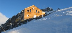
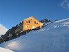
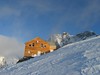
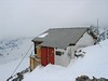

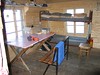
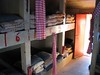
The Rifugio Marco e Rosa is the highest mountain hut in the Italian province of Lombardy. An ideal place for climbs to the peaks of Piz Bernina, Piz Zupo and Piz Argient. Open sporadically in winter, usually only on weekends. Spacious, but cold and unfurnished winter room.
Ski tours around Hut Rifugio Marco e Rosa
- Country
- Italy
- Montains
- Bernina Alps
- Open (winter)
- unknown
- Beds
- 48
- Winterraum
- open, 34 beds
- Shortening of access (cableway, lift, taxi, snowcat...)
- no
- Luggage transport
- no
- Shower
- yes
- Wifi
- yes
- UTM / CH1903 x ("longitude" E/W)
- 790163
- UTM / CH1903 y ("latitude" N/S)
- 138782
- Map
- 1277 Piz Bernina, Swisstopo 1:25000 S268 Julierpass, Swisstopo 1:50000
- Guides
- Graubünden Süd / SAC-CAS.ch, deutsch Die klassischen Skitouren (SAC, deutsch) Les classiques de randonnée à ski / SAC-CAS.ch, francais Engadin / Rother Skitourenführer, deutsch Scialpinismo tra Lombardia e Grignoni / Versante Sud, italiano
- Phone (hut)
- +39 0342 515370
- Phone (valley)
- +39 0342 454053
- Cell phone
- +39 347 2563096
- Mobile Signal
- yes
- Web
- rifugi.lombardia.it
- biancoextrem@libero.it
- Owner of hut
- CAI Sondrio
- Reservation
- e-mail, phone
- Start Point
- Morteratsch Bahnhof
- UTM / CH1903 x ("longitude" E/W)
- 792200
- UTM / CH1903 y ("latitude" N/S)
- 147447
- Altitude
- 1896 m
- Ascent (height difference)
- 1720 m
- Time of Access
- 8-10 h
- Shortening lift
- no
- Start Point
- Berghaus Diavolezza
- UTM / CH1903 x ("longitude" E/W)
- 794223
- UTM / CH1903 y ("latitude" N/S)
- 143181
- Altitude
- 2978 m
- Ascent (height difference)
- 950 m
- Time of Access
- 7-9 h
- Shortening lift
- yes, by cable car from Diavolezza-Lagalb train station to Berghaus Diavolezza
- Avalanche danger
- slf.ch - Institut für Schnee- und Lawinenforschung
- Weather
- Diavolezza / meteoblue.com Bovalhütte / srf.ch Diavolezza / snow-forecast.com Piz Bernina-La Spedla / mountain-forecast.com Piz Palü 3889m/ mountain-forecast.com St. Moritz / wetter.com Switzerland - animation / srf.ch Alpenvereinswetter
- Snow report
- Diavolezza - Lagalb / snow-forecast.com St. Moritz / onthesnow.com Diavolezza - Lagalb / bergfex.ch St. Moritz / snow.myswitzerland.com
- Webcams
- All webcams around St. Moritz Diavolezza
- Region
- Graubünden Engadin St. Moritz Pontresina
- Public traffic
- SBB Railway Postauto.ch - bus
- Skiresort nearby
- St. Moritz - Corviglia - Corvatsch - Diavolezza
- Other links
- Switzerland Tourism Regione Lombardia
hut Rifugio Marco e Rosa - Reviews
There are no reviews in this section yet. Click the Add Review button to add first review.
Best ski tours in mountains Bernina Alps, Italy
-

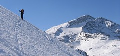
Cima di Rosso 3365 m
Fornohütte - Capanna del Forno Bernina Alps Switzerland
- Length of ascent7,5 km
- ascent1255 m
- duration4,5-6 h
- Fitness difficulty ♦♦♦◊
- Technical difficulty ♦♦♦◊
Cima di Rosso je skialpová klasika v oblasti Forno. Ledovcová túra s vynikajícim výhledem na Munt Disgrazia a Piz Bernina. Kromě sjezdu po trase výstupu je možná sjezdová alernativa severním svahem, kde bývá často prašan.

-
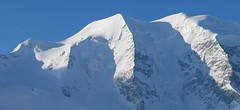
Piz Palü 3882 m
Diavolezza Berghaus Bernina Alps Switzerland
- Length of ascent6,5 km
- ascent1180 m
- duration6,5-8,5 h
- Fitness difficulty ♦♦♦◊
- Technical difficulty ♦♦♦◊
The Piz Palü with its characteristic three pillars is probably the most popular "not 4000" in the Alps. The exit from the Berghaus Diavolezza is ideal, it is also possible from the Bovalhütte. The key point for the ascent and descent is the passage of the Labyrinth between the Seraks. Continue over a relatively steep glacier to the ski depot. Then ascent with ice axe and crampons along the exposed summit ridge. The usual goal of ski mountaineers is the eastern summit - 3882 m.
-
Piz Surlej - Piz San Gian 3187 m
St. Moritz Bernina Alps Switzerland
- Length of ascent4 km
- ascent990 m
- duration4-6 h
- Fitness difficulty ♦♦◊◊
- Technical difficulty ♦♦♦◊
Piz Surlej and Piz San Gian is an interesting ski tour over two neighboring peaks. In the morning you take the cable car to Piz Corvatsch and enjoy the wonderful view of the Albula Alps as well as the lakes Sils and Silvaplana. Follow the ski slope to the Margun Vegl cable car station or to the upper station (2643 m). A logical line to Piz Surlej and further along the ridge to Piz San Gian. And then a spectacular descent to St. Moritz. Warning, some slopes of this ski tour have avalanche potential, especially the descent from the San Gian summit to St. Moritz. This tour is for skiers with good riding technique.
Best ski tours in Italy by skitour.guru
-

Weisseespitze - Cima del Lago Bianco 3532 m
Langtauferer Tal / Vallelunga - Melag Ötztaler Alpen Italy
- Length of ascent7 km
- ascent1615 m
- duration6-8 h
- Fitness difficulty ♦♦♦♦
- Technical difficulty ♦♦♦◊
Skialpinistická túra na Weisseespitze (italsky Cima del Lago Bianco) je špičkovým i náročným zážitkem. Vychází se z konce údolí Langtauferertal z vesničky Melag. Po snadném úvodu běžkařskou stopou následuje poměrně prudký výstup lavinovým svahem a poté dlouhý traverz. Po mírném svahu severním směrem, pak po zbytcích ledovce Falginfernen na úpatí strmého žlabu. S lyžemi na batohu kousek pod hřeben- skidepot. Na mačkách a s cepínem na vrchol. Ideální výhled na velkolepé ledovcové moře - největší ledovcovou pláň Rakouska. Letecké výhledy na ledovcový skiresort Kaunertal. Sjezdovou trasu si za dobrých podmínek můžete vylepšit najetím do kotle západně od výstupové stopy.
-

Cresta Bianca 2932 m
Dolomiti d´Ampezzo - Cortina, Cimabanche, Schluderbach Dolomiti Italy
- Length of ascent6 km
- ascent1380 m
- duration4-5,5 h
- Fitness difficulty ♦♦♦◊
- Technical difficulty ♦♦♦◊
Cresta Bianca je fantasická a náročná túra v masivu Cristallo. Po nástupu u hospůdky Cimabanche / Im Gemärk na rozhraní Südtirol a Veneto se stoupá členitým žlabem Val Pra de Vecia ve stínu severního svahu. Po dlouhém prudkém výstupu následuje traverz východním směrem do sedla Forcella Verde a dlouhý, ale přehledný výstup kotlem Graol de Forame až do sedla Forcella Granda. Odtud v mačkách na nedaleký vrchol Cresta Bianca. Pokud se na začátku sjezdu ze sedla budete držet vpravo, dostanete se do sedla s velkolepým výhledem na Tre Cime i kotel Val Fonda. Další sjezd kopíruje výstupovou trasu.
-

Oberbachernspitze / Croda Fiscalina Ovest 2677 m
Sextener Dolomiten / Dolomiti Sesto - Sexten, Fischleintal Dolomiti Italy
- Length of ascent km
- ascent1250 m
- duration h
- Fitness difficulty ♦♦♦◊
- Technical difficulty ♦♦◊◊
The ski tour to Oberbachernspitze is extremely interesting. From the Fischleintal valley, Talschlusshütte is heading for the wild valley of Rio Fiscalino. Under the monumental mountain Zwölferkogel turn right and climb a narrow gutter to the west. Further progress through the rugged terrain, to the right is the Zsigmondy Hütte. Continue to the right, northwest. The final passage through the steeper slope is not demanding on orientation. From the top a wonderful view to Tre Cime.