
 Česky
Česky Deutsch


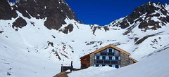


The Tuoi Hut is located below the Piz Buin, on the Swiss side of Silvretta, above the village of Guarda. Excellent location for valuable ski tours - Piz Buin, Piz Fliana, Piz da las Clavigliadas, Dreiländerspitze and both Jamspitzen. The advantage of the hut is the great runs to the hut on the steep slopes, especially the Buinlücke.
Tours starting from hut
Ski tours around Hut Tuoi Chamonna / Tuoihütte
-

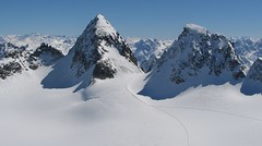
Piz Buin SE (Tuoihütte) 3312 m
Tuoi Chamonna / Tuoihütte Silvretta Switzerland
- Length of ascent5,5 km
- ascent1170 m
- duration5,5-7 h
- Fitness difficulty ♦♦♦◊
- Technical difficulty ♦♦♦◊
Piz Buin ze švýcarské strany je zajímavější túra než ze strany rakouské. výstup v závěrečné části je stejný. Pod stěnu vede trasa přes sedla Plan Mezdi a Fuorcla dal Cunfin. Za stabilní sněhové pokrývky je alternativou sjezd žlabem Buinlücke.

-

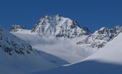
Vordere/ Hintere Jamspitze SW 3155 m
Tuoi Chamonna / Tuoihütte Silvretta Switzerland
- Length of ascent km
- ascent910 m
- duration3-4 h
- Fitness difficulty ♦♦◊◊
- Technical difficulty ♦♦◊◊
- Country
- Switzerland
- Montains
- Silvretta
- Open (winter)
- February - April
- Beds
- 74
- Winterraum
- open, 14 beds
- Shortening of access (cableway, lift, taxi, snowcat...)
- no
- Luggage transport
- no
- Card Pay
- no, cash - CHF only
- Shower
- no
- Wifi
- yes, for a fee 2€
- UTM / CH1903 x ("longitude" E/W)
- 805492
- UTM / CH1903 y ("latitude" N/S)
- 190129
- GPX access to hut (waipoints, track)
- Tuoi_Chamanna_access.gpx
- GPX all tours from the hut
- Silvretta_Tuoi_ALL.gpx
- Map
- Silvrettagruppe, OEAV 1:25000, Nr. 26 Tarasp, Landeskarte der Schweiz mit Skitouren 1:50000, Nr. 249 S
- Guides
- Skitourenführer Tirol / Alpinverlag, deusch Ötztal – Silvretta / Bergverlag Rother, deusch SCHITOUREN-ATLAS ÖSTERREICH WEST / Schall Verlag, deusch Graubünden Süd Skitouren / SAC-CAS, deutsch, french Engadin / Bergverlag Rother, deusch
- Phone (hut)
- 0041(0)81 862 23 22
- Phone (valley)
- 0041(0)79 682 32 23
- Cell phone
- -
- Mobile Signal
- no
- Web
- tuoi.ch
- info@tuoi.ch
- Owner of hut
- SAC Engiadina Bassa
- Reservation
- phone, e-mail, online
- Online reservation
- alpsonline.org
- Start Point
- Guarda - parking
- UTM / CH1903 x ("longitude" E/W)
- 806687
- UTM / CH1903 y ("latitude" N/S)
- 184040
- Altitude
- 1600 m
- Ascent (height difference)
- 730 m
- Time of Access
- 2,5-3 h
- Shortening lift
- no
- Avalanche danger
- slf.ch - Institut für Schnee- und Lawinenforschung
- Weather
- Tuoihütte / meteoblue.com Alpenverein.at - Ostalpen Bergwetter Tirol 2 days Piz Tasna 3179m / mountain-forecast.com Paraid Naira 3015m / mountain-forecast.com Fluchthorn 3399m / mountain-forecast.com ORF.at ZAMG Austria
- Snow report
- Scuol / snow-forecast.com Scuol / onthesnow.com Scuol / bergfex.ch
- Webcams
- Chamanna Tuoi Scuol - Motta Naluns
- Region
- Guarda Graubünden
- Public traffic
- SBB Railway Postauto.ch
- Skiresort nearby
- Scuol - Motta Naluns
- Other links
- Switzerland Tourism
hut Tuoi Chamonna / Tuoihütte - Reviews
There are no reviews in this section yet. Click the Add Review button to add first review.
Video of ski tour
Best ski tours in mountains Silvretta, Switzerland
-
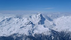
Piz Buin N (Wiesbadener H.) 3312 m
Wiesbadener Hütte Silvretta Austria
- Length of ascent5 km
- ascent1020 m
- duration5-6,5 h
- Fitness difficulty ♦♦◊◊
- Technical difficulty ♦♦♦♦
The ski tour to Piz Buin, the most famous Silvretta mountain in the form of a loaf is quite demanding at the end due to the exposed terrain. At the beginning on the Ochsental glacier from the Wiesbadener Hütte (or Bielerhöhe), at the end through rocky terrain. Depending on the conditions, it is advisable to secure the rope to the tricky rock.
-

Dreiländerspitze NW (Wiesbadener H.) 3197 m
Wiesbadener Hütte Silvretta Austria
- Length of ascent3,5 km
- ascent750 m
- duration4-5,5 h
- Fitness difficulty ♦♦♦◊
- Technical difficulty ♦♦♦♦
The ski tour to peak Dreiländerspitze is initially unpretentious. Climb from Wiesbadener Hut to the Ochsenscharte. Further unpleasant traverse to the rocky ridge. Skidepo - fitting crampons and ice axe, ascent alternately on both sides of the ridge to the top. There are several climbing steps just before the summit. Back along the ascent route.
-
Vordere Jamspitze from Jamtalhütte 3154 m
Jamtalhütte Silvretta Austria
- Length of ascent6 km
- ascent1050 m
- duration4,5-6 h
- Fitness difficulty ♦♦◊◊
- Technical difficulty ♦♦♦◊
Jamspitze is a very popular skitour from the Jamtalhütte. It is a light ski tour along the Jamtalferner glacier to the Jamspitze saddle. The saddle is followed by a sharp slope without skis in crampons.
Best ski tours in Switzerland by skitour.guru
-
Piz Platta 3392 m
Mulegns - Posthotel Löwen Platta Group / Oberhalbstein Switzerland
- Length of ascent11 km
- ascent1980 m
- duration8-11 h
- Fitness difficulty ♦♦♦♦
- Technical difficulty ♦♦♦◊
Impressive very long ski tour on the more pronounced Piz Platta summit in the Plattagruppe-Oberhalbstein mountain group. Aproach from the village of Mulengs - road from Tiefencastel to Julierpass. First a few kilometers through the forest, then left at the foot of the mountain and then constantly up the northeast slope to the plateau (ski depot). Next you have to climb the southern slope to the top plateau with crampons and ice axe.
-

Col Valpelline, Day 6 H.R. Chamonix-Zermatt 3551 m
Cabane des Vignettes Walliser Alpen / Alpes valaisannes Switzerland
- Length of ascent9 km
- ascent1485 m
- duration8-10 h
- Fitness difficulty ♦♦♦◊
- Technical difficulty ♦♦♦◊
The last stage of the Haute Route Chamonix - Zermatt is an ode to skiing. After an easy ascent to three saddles - Col de Eveque, Col du Mont Brulé and Col Valpelline. Every ski mountaineer will be amazed by the panorama of the impressive 4000m peaks - Dent Blanche, Matterhorn and Dent d´Hérens. This is followed by a 10 km descent to Zermatt.
-

Pazolastock - Piz Badus 2928 m
Andermatt - Realp - Oberalppass Urner Alps Switzerland
- Length of ascent6 km
- ascent1370 m
- duration4-6 h
- Fitness difficulty ♦♦◊◊
- Technical difficulty ♦♦◊◊
Vyhlídková, poměrně jednoduchá túra po hřebeni na Piz Badus přes Pazolastock. Na start túry je snadná cesta vlakem z Andermattu. Pozor na laviny při traverzu Pazolastocku. První sjezd je lehký a bezpečný. Logická výstupová linie přes hřeben pod Piz Badus. Na vrchol v mačkách nebo na lyžích, podle podmínek. Letecký pohled na Andermatt. Při sjezdu z Piz Badus pozor na strmý úsek za jezerem. Po nalepení pásů závěrečných 100 výškových metrů do sedla Oberalppass k vlaku (jezdí každou hodinu).