
 Česky
Česky Deutsch


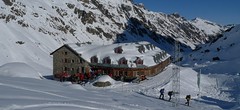


Jamtalhütte is a large mountain hut at the end of the Jamtal Valley. The Jamtalhütte is accessible from Galtür via the plucked road, and the snowcat taxi can be used. Medium and more challenging ski tours to all directions. Definitely a hut with the most skitours on Silvretta - Hintere and Vordere Jamspitze, Schnapfenspitze, Haagspitze, Nördliche Augstenspitze, Breite Krone and Dreiländerspitze. There is a climbing wall at the cottage.
Tours starting from hut
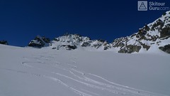
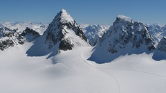
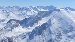
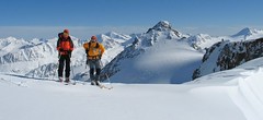
Ski tours around Hut Jamtalhütte
-
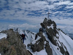
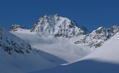
Dreiländerspitze NE (Jamtalhütte) 3197 m
Jamtalhütte Silvretta Austria
- Length of ascent6,5 km
- ascent1090 m
- duration5-6,5 h
- Fitness difficulty ♦♦♦◊
- Technical difficulty ♦♦♦♦
The ski tour to peak Dreiländerspitze is initially unpretentious. Climb the Jamtalferner glacier to the Ochsenscharte. Further unpleasant traverse to the rocky ridge. Skidepo - fitting crampons and ice axe, ascent alternately on both sides of the ridge to the top. There are several climbing steps just before the summit. Back along the ascent route.

-
Haagspitze East (Jamtalhütte) 3029 m
Jamtalhütte Silvretta Austria
- Length of ascent4,7 km
- ascent980 m
- duration4-6 h
- Fitness difficulty ♦♦♦◊
- Technical difficulty ♦♦♦♦
Skitour to the Haagspitze (east) from the Jamtalhütte is not technically demanding, the avalanche danger threatens both when climbing the Jamtalferner glacier and on the steep slope (35-40 °) of the final southern slope to the saddle below the summit.
-

Nördliche Augstenspitze Circuit 3228 m
Jamtalhütte Silvretta Austria
- Length of ascent10 km
- ascent1450 m
- duration6-8 h
- Fitness difficulty ♦♦♦◊
- Technical difficulty ♦♦♦◊
Nördliche Augstenspitze is a comprehensive and varied skitour from the Jamtalhütte. First goes to the saddle through the Chalausferner glacier to Fuorcla chalaus saddle, usually in crampons. Short descent to the Oberer Augstenferner Glacier. At the end in crampons and with ice ax to the top. A possible alternative is to extend the tour through Urezzasjoch.
-
Piz Tasna from Jamtalhütte 3179 m
Jamtalhütte Silvretta Austria
- Length of ascent9 km
- ascent1460 m
- duration7-8,5 h
- Fitness difficulty ♦♦♦◊
- Technical difficulty ♦♦◊◊
Piz Tasna je i přes delší vzdálenost dostupná z chaty Jamtalhütte. Dlouhým údolím do sedla Kronenjoch, pak krátký sjezd severovýchodním svahem. Následně doprava - jižním směrem na pláň, ze které se vystoupá do sedla. Odtup bez lyží v mačkách a s cepnem na vrchol s kamzíkem.
-

Hintere Jamspitze from Jamtalhütte 3156 m
Jamtalhütte Silvretta Austria
- Length of ascent7 km
- ascent1030 m
- duration3,5-5 h
- Fitness difficulty ♦♦◊◊
- Technical difficulty ♦♦◊◊
Skialpová túra na Hintere Jamspitze je zajímavý okruh. Nahoru směrem k sedlu Urezzas Joch a před ním doprava do sedla Jamjoch. Kousek pod sedlem je skalní průvlak. Pokud je dost sněhu tak na lyžích až na vrchol. Skvělý sjezd po spádnici až k chatě.
-
Vordere Jamspitze from Jamtalhütte 3154 m
Jamtalhütte Silvretta Austria
- Length of ascent6 km
- ascent1050 m
- duration4,5-6 h
- Fitness difficulty ♦♦◊◊
- Technical difficulty ♦♦♦◊
Jamspitze is a very popular skitour from the Jamtalhütte. It is a light ski tour along the Jamtalferner glacier to the Jamspitze saddle. The saddle is followed by a sharp slope without skis in crampons.
-

Schnapfenspitze SW (Jamtalhütte) 3179 m
Jamtalhütte Silvretta Austria
- Length of ascent4,3 km
- ascent1060 m
- duration4-6 h
- Fitness difficulty ♦♦♦◊
- Technical difficulty ♦♦♦♦
Schnapfenspitze south slope is a rather challenging ski tour through the Fluchthornferner glacier with steep sections. Avalanche danger in traverse to the saddle and then easily to the summit.
-

Grenzeckkopf - Breite Krone 3079 m
Jamtalhütte Silvretta Austria
- Length of ascent6,5 km
- ascent1040 m
- duration4-6 h
- Fitness difficulty ♦♦◊◊
- Technical difficulty ♦♦◊◊
Skialpová túra přes snadné vrcholky Grenzeckkopf, Bischofspitze a Breite Krone z chaty Jamtalhütte vede pozvolným údolím východním směrem k balvanu Finanzerstein. odtud do pravého ze dvou sedel na obzoru. Z vrcholu Grenzeckkopf a vrcholek Bischofspitze do sedla Kronenjoch. Ze sedla po širokém svahu na Breite Krone (Curuna Lada). Pak sjezd, krátký výstup do sedla Kronenjoch a dlouhý, v první polovině zajímavý sjezd až k Jamtalhütte.
- Country
- Austria
- Montains
- Silvretta
- Open (winter)
- mid February - mid May
- Beds
- 150
- Winterraum
- open, 12 beds
- Shortening of access (cableway, lift, taxi, snowcat...)
- yes, by snowcat from Galtür
- Luggage transport
- yes, by snowcat from Galtür, must be ordered
- Card Pay
- yes
- Shower
- yes
- Wifi
- yes, for a fee
- UTM / CH1903 x ("longitude" E/W)
- 32T 589625
- UTM / CH1903 y ("latitude" N/S)
- 5193200
- GPX access to hut (waipoints, track)
- Jamtal Hütte access.gpx
- GPX access to hut (track only)
- JamtalH-access_TRACK.gpx
- GPX all tours from the hut
- Silvretta Jamtalhuette_ALL.gpx
- Map
- Silvrettagruppe, OEAV 1:25000, Nr. 26 Tarasp, Landeskarte der Schweiz mit Skitouren 1:50000, Nr. 249 S
- Guides
- Skitourenführer Tirol / Alpinverlag, deutsch Ötztal – Silvretta / Bergverlag Rother, deutsch SCHITOUREN-ATLAS ÖSTERREICH WEST / Schall Verlag, deusch Graubünden Süd Skitouren / SAC-CAS, deutsch, french
- Phone (hut)
- 0043/5443/8408
- Phone (valley)
- 0043/5443/8394
- Cell phone
- -
- Mobile Signal
- yes
- Web
- jamtalhuette.at
- info@jamtalhuette.at
- Owner of hut
- DAV Sektion Schwaben
- Jamtalhütte
- Reservation
- online form
- Online reservation
- jamtalhuette.at
- Start Point
- Galtür - parking SPORT & KULTURZENTRUM
- UTM / CH1903 x ("longitude" E/W)
- 32T 590489
- UTM / CH1903 y ("latitude" N/S)
- 5202193
- Altitude
- 1585 m
- Ascent (height difference)
- 615 m
- Time of Access
- 3 - 4 h
- Shortening lift
- yes, by snowcat from Galtür (must be ordered)
- Avalanche danger
- lawine.at
- Weather
- Jamtalhütte / yr.no Alpenverein.at - Ostalpen Bergwetter Tirol 2 days Jamtal Ferner / meteoblue.com Augstenspitze / mountain-forecast.com Dreiländerspitze / mountain-forecast.com Tirol / ORF.at Austria ZAMG
- Snow report
- Galtür / snow-forecast.com Galtür / onthesnow.com Galtür / bergfex.at
- Webcams
- Galtür - Ballunspitzbahn Palinkopf 2864 (Ischgl) Chamanna Tuoi (CH) Galtür - Dorf UrezzasJoch - to Jamtalferner
- Region
- Paznaun - Ischgl Silvretta - Montafon
- Public traffic
- ÖBB Railway Postbus
- Skiresort nearby
- Skigebiet Galtür / Paznaun-Ischgl Ischgl
- Other links
- Austria Tourism
hut Jamtalhütte - Reviews
There are no reviews in this section yet. Click the Add Review button to add first review.
Best ski tours in mountains Silvretta, Austria
-
Piz Buin N (Wiesbadener H.) 3312 m
Wiesbadener Hütte Silvretta Austria
- Length of ascent5 km
- ascent1020 m
- duration5-6,5 h
- Fitness difficulty ♦♦◊◊
- Technical difficulty ♦♦♦♦
The ski tour to Piz Buin, the most famous Silvretta mountain in the form of a loaf is quite demanding at the end due to the exposed terrain. At the beginning on the Ochsental glacier from the Wiesbadener Hütte (or Bielerhöhe), at the end through rocky terrain. Depending on the conditions, it is advisable to secure the rope to the tricky rock.
-

Piz Buin SE (Tuoihütte) 3312 m
Tuoi Chamonna / Tuoihütte Silvretta Switzerland
- Length of ascent5,5 km
- ascent1170 m
- duration5,5-7 h
- Fitness difficulty ♦♦♦◊
- Technical difficulty ♦♦♦◊
Piz Buin ze švýcarské strany je zajímavější túra než ze strany rakouské. výstup v závěrečné části je stejný. Pod stěnu vede trasa přes sedla Plan Mezdi a Fuorcla dal Cunfin. Za stabilní sněhové pokrývky je alternativou sjezd žlabem Buinlücke.
-

Piz Tasna from Heidelberger Hütte 3179 m
Heidelberger Hütte Silvretta Austria
- Length of ascent7 km
- ascent980 m
- duration6,5-8 h
- Fitness difficulty ♦♦♦◊
- Technical difficulty ♦♦♦◊
Piz Tasna je oblíbený vrchol oblasti kolem Heidelberger Hütte. Cesta pod horu údolím Fimbertal je velmi dlouhá. Na vrcholovém hřebeni pozor, jde o exponovaný terén. Obtížnost v závěru hodně záleží na podmínkách.
Best ski tours in Austria by skitour.guru
-

Wilder Pfaff (from Hildesheimer Hütte) 3458 m
Hildesheimer Hütte Stubai Alps Austria
- Length of ascent4,5 km
- ascent700 m
- duration3-4,5 h
- Fitness difficulty ♦♦◊◊
- Technical difficulty ♦♦♦◊
Wilder Pfaff a Zuckerhütl je lákavými cíli z winterraumu chaty Hildesheimer Hütte. Prudký sjezd svahu od chaty na dno karu má velký lavinový potenciál a proto vyžaduje dodržování všech bezpečnostních opatření. Ze dna karu (2750 m) do sedla Pfaffenjoch a po plochém ledovci pod vrcholovou část.Ke kříži je většinou možné vyšlapat na lyžích. Pro sjezd existují dvě možnosti. Buď po trase výstupu zpět na chatu nebo po ledovci Sulzenauferner do údolí Stubaital. Na ledovci dávejte velký pozor na četné ledovcové trhliny.
-
Weisseck 2711 m
Zederhaus - Kirchenwirt Niedere Tauern Austria
- Length of ascent7 km
- ascent1450 m
- duration5-7 h
- Fitness difficulty ♦♦♦◊
- Technical difficulty ♦♦♦◊
Ski tour to the impressive Weisseck. In good conditions, a spectacular Ödenkar boiler descent is offered. If we don't climb to the Weisseck, the beautiful Ferskarspitze is on the way. Through the forest you reach the valley "In hell" (In der Hölle) - on one side of the rock towers, on the other side of the wall of Weisseck. Enter the Ödenkar from the upper plateau with the summit cross and watch out for snow guards and a very steep start.
-
Fluchtkogel SE, from Vernagthütte 3500 m
Vernagthütte Ötztal Alps / Alpi Venoste Austria
- Length of ascent4 km
- ascent740 m
- duration3-4,5 h
- Fitness difficulty ♦♦♦◊
- Technical difficulty ♦♦◊◊
Túra na Fluchtkogel z Vernagthütte je výletem za krásnými výhledy přes celé Ötztálské Alpy. Jediný prudší úsek je pod sedle Oberes Guslarjoch a ještě v závěrečném svahu na plochý vrchol. Dolů kolem výstupových stop.