
 Česky
Česky Deutsch


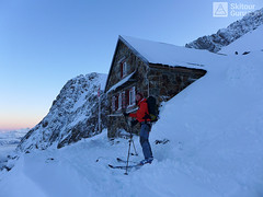


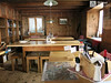
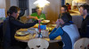


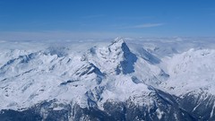
Trifthütte mountain hut over the northern edge of the giant glacier. Sanitary facilities after reconstruction in 2014. Origin of many top skitours at Dammastock, Diechterhorn, Eggstock, Wysse Nolen, Steinhüshorn, Tieralplistock. An important hut for the Swiss Glacier and Urner Haute Route.
Tours starting from hut
Ski tours around Hut Trifthütte

- Country
- Switzerland
- Montains
- Urner Alps
- Open (winter)
- march-may
- Beds
- 42
- Winterraum
- 0
- Shortening of access (cableway, lift, taxi, snowcat...)
- no
- UTM / CH1903 x ("longitude" E/W)
- 671768
- UTM / CH1903 y ("latitude" N/S)
- 170063
- GPX access to hut (waipoints, track)
- Guttannen-TrihtHut_ACCESS_SKITOURGURUcom.gpx
- GPX all tours from the hut
- TriftHut allTOUR_WPT_SkitourGuru.gpx
- Map
- Sustenpass 255 S, Swisstopo 1:50000 Innertkirchen 1210, Swisstopo 1:25000
- Guides
- Alpine Skitouren Zentralschweiz – Tessin", SAC Verlag Zentralschweizer Voralpen und Alpen Die klassischen Skitouren (SAC, deutsch) Les classiques de randonnée à ski (SAC, francais) Scialpinismo in Svizzera Zentralschweiz (Rother, deutsch)
- Phone (hut)
- +41 (0)33 975 12 28
- Phone (valley)
- -
- Cell phone
- 0041 (0) 774089801
- Web
- www.trifthuette.ch
- info@trifthuette.ch
- Owner of hut
- SAC Bern
- Trifthütte
- Start Point
- Guttannen
- UTM / CH1903 x ("longitude" E/W)
- 665149
- UTM / CH1903 y ("latitude" N/S)
- 167408
- Altitude
- 1057 m
- Ascent (height difference)
- 2120 m
- Time of Access
- 8-11 h
- Shortening lift
- no
- Avalanche danger
- SLF
- Weather
- SRF Meteo Meteoschweiz snow-forecast.com - Andermatt Meteoblue - Trifthütte Meteoblue - Diechterhorn yr.no - Trifthütte
- Snow report
- snow-forecast.com - Engelberg snow-forecast.com - Andermatt bergfex.ch - Engelberg bergfex.ch - Andermatt onthesnow.com - Andermatt skiresort.info Melchsee-Frutt snow.myswitzerland.com Melchsee-Frutt
- Webcams
- Guttannen Räterichsboden Gelmersee Andermatt
- Region
- Haslital Zentralschweiz Tourismus
- Public traffic
- Vlaky Linkové autobusy
- Skiresort nearby
- Engelberg Melchsee-Frutt Andermatt
- Other links
- Haslital Hütten
hut Trifthütte - Reviews
There are no reviews in this section yet. Click the Add Review button to add first review.
Best ski tours in mountains Urner Alps, Switzerland
-

Chli Bielenhorn 2940 m
Andermatt - Realp - Oberalppass Urner Alps Switzerland
- Length of ascent8,5 km
- ascent1450 m
- duration5-6,5 h
- Fitness difficulty ♦♦♦◊
- Technical difficulty ♦♦◊◊
Chli Bielenhorn je skalnatá špička v říši monumentálních žulových stěn divokých hor. Začátek kolem silnice na Furkapass pokračuje po pláni pod chatou Albert-Heim-Hütte. Pak přichází v sousedství pohled na ledovce monumentálního Dammastocku. V kulisách skal vede logická linie ke skidepu kousek pod vrcholem. V případě stabilního sněhu je fajn alternativou sjezdová linie jižně od výstupové stopy a dále členitým terénem k hotelu Tiefenbach a v okolí silnice nebo po ní zpět do Realpu.

-
Pizzo Lucendro 2963 m
Rotondohütte Urner Alps Switzerland
- Length of ascent5,5 km
- ascent1090 m
- duration4-6 h
- Fitness difficulty ♦♦◊◊
- Technical difficulty ♦♦♦◊
Pizzo Lucendro je výrazný vrchol nad Gotthardpassem a také prvotřídní rozhledna. Na túru lze vyrazit z údolního Realpu, snazší je start z chaty Rotondohütte. Po sjezdu nad úroveň salaší nastává dlouhý výstup členitým terénem, který nabírá na strmosti. Těsně pod skalním sedlem je v úzkém koridoru zvládání otočky nutností. Za sedlem následuje poměrně snadný výstup do sedla, k místu, kde bývá depo lyží. Při výstupu po hřebeni k vrcholovému kříži pozor na převěje a místy exponovaný terén. Při sjezdu za jarního firnu se vyplatí počkat v sedle, než slunce změkčí stinný svah pro velkolepý odpolední sjezd západním svahem. Z nejnižšího bodu návrat na chatu nebo sjezd až do Realpu.
-

Pazolastock - Piz Badus 2928 m
Andermatt - Realp - Oberalppass Urner Alps Switzerland
- Length of ascent6 km
- ascent1370 m
- duration4-6 h
- Fitness difficulty ♦♦◊◊
- Technical difficulty ♦♦◊◊
Vyhlídková, poměrně jednoduchá túra po hřebeni na Piz Badus přes Pazolastock. Na start túry je snadná cesta vlakem z Andermattu. Pozor na laviny při traverzu Pazolastocku. První sjezd je lehký a bezpečný. Logická výstupová linie přes hřeben pod Piz Badus. Na vrchol v mačkách nebo na lyžích, podle podmínek. Letecký pohled na Andermatt. Při sjezdu z Piz Badus pozor na strmý úsek za jezerem. Po nalepení pásů závěrečných 100 výškových metrů do sedla Oberalppass k vlaku (jezdí každou hodinu).
Best ski tours in Switzerland by skitour.guru
-

Clariden E, from Claridenhütte 3267 m
Claridenhütte Glarus Alps Switzerland
- Length of ascent6 km
- ascent1025 m
- duration4,5-6 h
- Fitness difficulty ♦♦◊◊
- Technical difficulty ♦♦◊◊
After Tödi, Clariden is the second most popular ski tour in the Glarus Alps. The ascent leads along the gentle Claridenfirn glacier from Claridenhütte to the foot of Clariden and then through a wide northeast slope to the top pyramid. Beautiful views of the entire Glarus Alps and the neighboring Uri Alps. Descent copies the ascent track. A popular alternative is to continue crossing the Planura hut after descending the steep slope turn right to Claridenpass.
-

Tour du Ciel - day 5 3030 m
Turtmannhütte / Cabane Tourtemagne Walliser Alpen / Alpes valaisannes Switzerland
- Length of ascent5,5 km
- ascent1110 m
- duration5-7 h
- Fitness difficulty ♦♦◊◊
- Technical difficulty ♦♦◊◊
A relatively easy ascent, though steep in places, from Lake Turtmannsee, which is reached by descending from the Turtmannhütte. From the summit ridge, there's a long descent to the Hotel Weisshorn, followed by forest trails leading down to the village of St. Luc - Chandolin in the Val d'Anniviers.
-
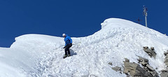
Piz Platta 3392 m
Mulegns - Posthotel Löwen Platta Group / Oberhalbstein Switzerland
- Length of ascent11 km
- ascent1980 m
- duration8-11 h
- Fitness difficulty ♦♦♦♦
- Technical difficulty ♦♦♦◊
Impressive very long ski tour on the more pronounced Piz Platta summit in the Plattagruppe-Oberhalbstein mountain group. Aproach from the village of Mulengs - road from Tiefencastel to Julierpass. First a few kilometers through the forest, then left at the foot of the mountain and then constantly up the northeast slope to the plateau (ski depot). Next you have to climb the southern slope to the top plateau with crampons and ice axe.