
 Česky
Česky Deutsch


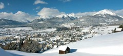
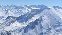
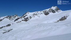
Tamsweg is the starting town for several ski tours in Lungau. The most famous route leads to Preber, directly above the town. In the immediate vicinity, there are routes to Zechnerkarspitze, as well as ski tour routes that are suitable and easier to Gstoder, Grosses Gurpitscheck, and Gumma.
Tours starting from hut
Ski tours around Hut Tamsweg - Lungau
- Country
- Austria
- Montains
- Niedere Tauern
- Open (winter)
- Beds
- 0
- Winterraum
- Shortening of access (cableway, lift, taxi, snowcat...)
- available by car
- Card Pay
- yes
- Shower
- yes
- Wifi
- yes
- UTM / CH1903 x ("longitude" E/W)
- 33T 409595
- UTM / CH1903 y ("latitude" N/S)
- 5220283
- Map
- Niedere Tauern, OEAV 1:25000, Nr. 45/II
- Guides
- SCHITOURENFÜHRER ÖSTERREICH Band I / Alpinverlag, DE SCHITOUREN-ATLAS ÖSTERREICH OST, Schall-Verlag
- Phone (hut)
- -
- Phone (valley)
- -
- Cell phone
- -
- Mobile Signal
- yes
- Web
- lungau.at
- info@tourismuslungau.at
- Owner of hut
- -
- Salzburger Lungau
- Online reservation
- booking.com
- Avalanche danger
- Lawine Salzburg
- Weather
- Tamsweg / Meteoblue.com Preber / Meteoblue.com Greim (Woelzer Tauern) 2474m / mountain-forecast.com Ostalpen / alpenverein.at Nieder Tauern Bergwetter 2 days / orf.at Salzburgland / orf.at Austria / ZAMG Skiwetter - Obertauern
- Snow report
- www.snow-forecast.com - Katschberg-Aineck www.snow-forecast.com - Obertauern
- Webcams
- Krakauschatten 1286m Speireck - St. Michael im Lungau Katschberg Obertauern Zederhaus - Autobahn
- Region
- Lungau
- Public traffic
- Postbus ÖBB Railway
- Skiresort nearby
- Lungau
- Other links
- Lungau.at - skitouren
hut Tamsweg - Lungau - Reviews
There are no reviews in this section yet. Click the Add Review button to add first review.
Best ski tours in mountains Niedere Tauern, Austria
-
Mosermandl 2677 m
Zederhaus - Kirchenwirt Niedere Tauern Austria
- Length of ascent8,5 km
- ascent1405 m
- duration6,5-7 h
- Fitness difficulty ♦♦♦◊
- Technical difficulty ♦♦♦◊
Gross Mosermandl je spolu s Weisseckem absolutním highlightem oblasti Zederhaustal v regionu Salzburger Lungau. Z parkoviště Wald se stoupá nejprve mírně údolím, pak po lesní cestě nahoru nad hranici lesa. Následují už svahy se sklonem 30 stupňů a větším. Nejobtížnější pasáž je v závěru výstupu, většinou bez lyží, v mačkách. Sjezd kopíruje trasu výstupu. Při dostatku času a sil je možné jít do Waldu přes kopec Schöpfling a místo cesty údolím si užít hezký sjezd.

-
Felskarspitze 2506 m
Zederhaus - Kirchenwirt Niedere Tauern Austria
- Length of ascent6,5 km
- ascent1195 m
- duration4-5,5 h
- Fitness difficulty ♦♦♦◊
- Technical difficulty ♦♦◊◊
Skialpová túra na Felskarspitz je skvělá. Dolní polovina je v lese s možností hezkého sjezdu, horní čás je ve znamení ledovcového karu a mohutné jihovýchodní stěny Weissecku. Sjezd většinou závětrnou kotlinou, sklon tak akorát a místo pro všechny. Díky severní expozici často prašan. Pokud jsou dobré podmínky, vyplatí se z vrcholu pokračovat na Weisseck a prožít fantastický, dlouhý sjezd.
-
Weisseck 2711 m
Zederhaus - Kirchenwirt Niedere Tauern Austria
- Length of ascent7 km
- ascent1450 m
- duration5-7 h
- Fitness difficulty ♦♦♦◊
- Technical difficulty ♦♦♦◊
Ski tour to the impressive Weisseck. In good conditions, a spectacular Ödenkar boiler descent is offered. If we don't climb to the Weisseck, the beautiful Ferskarspitze is on the way. Through the forest you reach the valley "In hell" (In der Hölle) - on one side of the rock towers, on the other side of the wall of Weisseck. Enter the Ödenkar from the upper plateau with the summit cross and watch out for snow guards and a very steep start.
Best ski tours in Austria by skitour.guru
-

Weisskugel East, from Hochjoch Hospiz 3739 m
Hochjoch Hospiz Ötztal Alps / Alpi Venoste Austria
- Length of ascent11 km
- ascent1550 m
- duration7-10 h
- Fitness difficulty ♦♦♦♦
- Technical difficulty ♦♦♦◊
Skialpinistická túra na Weisskugel je obtížná především svou délkou. Začátek túry se liší podle sněhové situace. Když je málo sněhu, jde se po rampě, víceméně po vrstevnici k ledovci Hintereisferner. Po ledovci mírně nahoru západním směrem. Prudký je až výšvih do sedla Hintereisjoch, odkud se stoupá doprava, severním směrem k vrcholu. Poslední desítky metrů vedou exponovaným terénem, hodně záleží na množství sněhu.
-
Dreiherrnspitze 3499 m
Essener-Rostocker Hütte Venedigergruppe - Hohe Tauern Austria
- Length of ascent8,6 km
- ascent1430 m
- duration9-11 h
- Fitness difficulty ♦♦♦♦
- Technical difficulty ♦♦♦◊
The Dreiherrnspitze is a spectacular, complex and challenging glacier ski tour. Especially difficult is its length, glacial cracks and terrain break at the end. First, it is easy to climb glacier the Südl. Malhamkees to Regentörl saddle. After a short downhill northwards to the Umbalkees Glacier, the traverse between the cracks and then to the Althauskees. Relatively steep slope to difficult terrain break (depending on snow conditions). After overcoming it, there is only 200 high meters in easy terrain. Downhill same track as ascent.
-

Mittlerer Seelenkogel 3426 m
Langtalereckhütte Ötztal Alps / Alpi Venoste Austria
- Length of ascent5 km
- ascent1000 m
- duration4-5,5 h
- Fitness difficulty ♦♦◊◊
- Technical difficulty ♦♦♦◊
Mittlerer Seelenkogel (Langtalereck Hütte, Ötztaler Alpen) is a rather difficult skitour for his second half. Traverse in steep terrain and the finish can be done under good conditions only.