
 Česky
Česky Deutsch


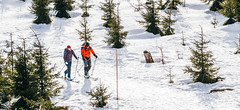


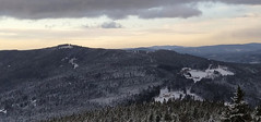
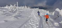
Oblast s nejvyššími vrcholy na české straně Šumavy. Plechý, Třístoličník a Smrčina jsou vycholy dostupné na skialpech z Nové Pece.
Tours starting from hut
Ski tours around Hut Trojmezí - Šumava
-
Smrčina - Hochficht 1333 m
Trojmezí - Šumava Bohemian Forest Czech
- Length of ascent13 km
- ascent840 m
- duration5-6,5 h
- Fitness difficulty ♦♦◊◊
- Technical difficulty ♦◊◊◊
On the top of Smrčina-Hpochficht, the highest point of the Austrian ski area Hochficht is located, from the czech side you must visit Nová Pec with ski and skins. A circuit through the Šumava forestes is offered. As Plechý is Smrčina also an ideal area for fitness ski tours.
-

Třístoličník - Plechý 1378 m
Trojmezí - Šumava Bohemian Forest Czech
- Length of ascent10 km
- ascent840 m
- duration5,5-7 h
- Fitness difficulty ♦♦◊◊
- Technical difficulty ♦◊◊◊
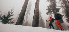
The ski tour to the highest part of the Šumava ridge leads over three important peaks. Hochstein 1333 m on the German side, Třístoličník 1302 m (Dreisesselberg) and finally Plechý (Plöckenstein), the highest point in the Czech part of Šumava. From above there is a view of the Plešné jezero lake, which separates the Jezerní stěna wall from the ridge. The route mainly leads along forest roads. The marked path along the ridge leads through the intersection of three borders - the Czech Republic, Germany (Bavaria) and Austria (Upper Austria). Refreshments are available in the Hut Berggasthof Dreisessel under Třístolicník. The ski tour can be included in the category of fitness ski tours and does not expect any downhill experiences. It is an ideal train ride from Nová Pec (the destination point) to Nové Údolí station, where this ski tour begins.

- Country
- Czech
- Montains
- Bohemian Forest
- Open (winter)
- Beds
- 0
- Winterraum
- Shortening of access (cableway, lift, taxi, snowcat...)
- UTM / CH1903 x ("longitude" E/W)
- 33U 423132
- UTM / CH1903 y ("latitude" N/S)
- 5404621
- Map
- Šumava - Lipno, 1:25000, Nr. 73, Geodézie On-Line Šumava - Trojmezí, 1:25000, Nr. 81, Geodézie On-Line
- Guides
- Skitour.Guru
- Phone (hut)
- -
- Phone (valley)
- -
- Cell phone
- -
- Web
- -
- -
- Owner of hut
- -
- Weather
- Plechý - Plöckenstein 1379m, mountain-forecast.com Hochficht - Smrčina, snow-forecast.com Hochficht, wetteronline.de Plechý, ventusky.com Plechý, meteoblue.com Nová Pec, ventusky.cz Nová Pec, meteoblue.com Třístoličník, meteoblue.com Předpovědní model Aladin Komplexní meteoservis Czech Republic
- Snow report
- Hochficht, snow-forecast.com Lipno, snow-forecast.com Lipno, snow.cz Lipno, bergfex.com České Žleby, bergfex.com
- Webcams
- Hochficht - Smrčina Třístoličník - Dreisesselhaus Strážný - pohled na hřeben Šumavy Stožec - České Žleby Šumava webcams
- Region
- Šumava - tourismus NP Šumava sumava.cz zelezna-ruda.cz Nová Pec Lipno sumavanet.cz
- Public traffic
- Vlaky Autobusy
- Skiresort nearby
- Lipno Hochficht AUT České Žleby
hut Trojmezí - Šumava - Reviews
There are no reviews in this section yet. Click the Add Review button to add first review.
Video of ski tour
Best ski tours in mountains Bohemian Forest, Czech
-
Pancíř z Javorné, okruh 1214 m
Železná Ruda - Prášily Bohemian Forest Czech
- Length of ascent7 km
- ascent575 m
- duration3-4 h
- Fitness difficulty ♦◊◊◊
- Technical difficulty ♦◊◊◊
Jednoduchá kondiční túra po mírných svazích pro úplné začátečníky. Okruh začíná a končí ve skiareálu Javorná.
-
Poledník 1315 m
Železná Ruda - Prášily Bohemian Forest Czech
- Length of ascent km
- ascent m
- duration h
- Fitness difficulty ♦◊◊◊
- Technical difficulty ♦◊◊◊
Jednoduchá túra pro začátečníky vystupuje na Poledník po běžkařské trase. Sjezd vede přes Prášilské jezero. Dokonalá ukázka řádění orkánu Kyrill na hřebenu Šumavy.
-

Špičák - Čertovo jezero, okruh 1202 m
Železná Ruda - Prášily Bohemian Forest Czech
- Length of ascent5 km
- ascent400 m
- duration1,5-2 h
- Fitness difficulty ♦◊◊◊
- Technical difficulty ♦◊◊◊
Kondiční túra kolem Špičáku. Vystoupat na vrchol k rozhledně se dá buď přes Špičácké sedlo nebo z druhé strany přes Čertovo jezero. Optimální je výstup na Špičák a po sjezdovce dolů. Následně totéž z druhé strany.
Best ski tours in Czech by skitour.guru
-

Krkonoše haute route, day 1 1509 m
Špindlerův Mlýn Giant Mountains Czech
- Length of ascent17 km
- ascent1470 m
- duration6-9 h
- Fitness difficulty ♦♦♦◊
- Technical difficulty ♦♦◊◊
The ski mountaineering crossing of the highest Czech mountains, the Giant Mountains, begins in Špinlerův Mlýn. Via Horní Mísečky and the edge of Kotelní jáma you climb to Dvoračky and further along the ridge to Labská bouda. The highlight of the tour is the ascent to Vysoké kolo and the subsequent descent to Martinova bouda or Brádlerovy boudy.
-
Keprník 1423 m
Chata Jiřího na Šeráku Jeseniky Czech
- Length of ascent7,5 km
- ascent610 m
- duration4,5-6 h
- Fitness difficulty ♦◊◊◊
- Technical difficulty ♦◊◊◊
Jesenická haute route pro děti je původně běžkařskou trasou, ale pro rodiče s dětmi to může být hezký skialpový zážitek. Zcela bezpečná, vyhlídková túra. Pozor, na hřebenu Keprníku bývá často větrno - buďte správně oblečeni. Optimální je začít na Červenohorském sedle a přes Červenou horu vystoupat na Keprník. Odtud sjezd směrem Chata Jiřího na Šeráku. Odtud buď završení túry sjezdem do Ramzové nebo cesta zpět po stejné trase. Z Ramzovského sedla se dá jet vlakem do Jeseníku a odtud autobusem zpět na Červenohorské sedlo. Trasa je možná v obou směrech, výhodnější je začít v ČH sedle.
-

Javorový 947 m
Moravskoslezské Beskydy Beskydy Czech
- Length of ascent3,5 km
- ascent500 m
- duration2-2,5 h
- Fitness difficulty ♦◊◊◊
- Technical difficulty ♦◊◊◊
Kopec Javorový je domácí horou pro třinecké horaly. Vede na něj lanovka a dolů z kopce se dá lyžovat po sjezdovce. 500 výškových metrů z Oldřichovic je ideální dávka pro tréninkový fitness skitouring.