
 Česky
Česky Deutsch


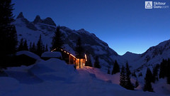


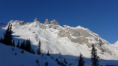
Lindauer Hütte is hut under the impressive dolomite rock towers of Rätikon, on the borders of Austria and Switzerland. Nearby is the Golm Ski Resort in Montafon. Two great skitours in the shadow of the rock towers at Sulzfluh and Drusenturm - both can only be done under excellent conditions. You can also cross the Drusator saddle to the swiss side of Rätikon.
Tours starting from hut
Ski tours around Hut Lindauer Hütte
-

Sulzfluh N 2818 m
Lindauer Hütte Rätikon Austria
- Length of ascent5,5 km
- ascent1300 m
- duration5-7 h
- Fitness difficulty ♦♦♦◊
- Technical difficulty ♦♦♦◊
Sulzfluh (Lindauer Hütte, Rätikon) is a very challenging ski tour through the rocky slopes "In der Rachen" (in the throat). From the top are great views of the mountains of eastern Switzerland and Silvretta.

-

Grosser Drusenturm - Drei Türme 2830 m
Lindauer Hütte Rätikon Austria
- Length of ascent5,5 km
- ascent1090 m
- duration4-6 h
- Fitness difficulty ♦♦♦◊
- Technical difficulty ♦♦♦◊
Grosser Drusenturm is a very challenging ski tour in Ratikon, Austria (Montafon, Vorarlberg) from Lindauer Hütte to the rocky peak of Grosser Drusenturm. Due to a very steep, 300-meter altitude below the summit, it can be realized only under excellent conditions (weather, stable snow).
-
Drusator 2364 m
Lindauer Hütte Rätikon Austria
- Length of ascent4 km
- ascent592 m
- duration2-3,5 h
- Fitness difficulty ♦♦◊◊
- Technical difficulty ♦♦◊◊
Drusator is a medium difficult ski tour of the austrian Rätikon (Montafon, Vorarlberg) from Lindauer Hütte to the Drusator saddle. Over the saddle you can reach the Partnun on the swiss side of Rätikon (Berghaus Sulzfluh, Carschina Hütte).
- Country
- Austria
- Montains
- Rätikon
- Open (winter)
- 20.12-11.1. , end of January to mid March
- Beds
- 200
- Winterraum
- 0
- Shortening of access (cableway, lift, taxi, snowcat...)
- no
- UTM / CH1903 x ("longitude" E/W)
- 32T 563488
- UTM / CH1903 y ("latitude" N/S)
- 5209331
- GPX access to hut (waipoints, track)
- Lindauer-Huette-access-SkitourGuru.gpx
- GPX all tours from the hut
- Lindauer Huette AUT RATIKON skitourguru.gpx
- Map
- Montafon 238 S, Swisstopo - Skitourenkarte, 1:50000 Sulzfluh 1157, Swisstopo - Landeskarten, 1:25000 Schesaplana 1156, Swisstopo - Landeskarten, 1:25000
- Guides
- Vorarlberg (deutsch, Rother Skitourenführer) Das perfekte Skitouren-Wochenende (deutsch, Rother Skitourenführer) Die schönsten Skidurchquerungen in den Alpen (deutsch, Bruckmann Verlag)
- Phone (hut)
- 0043 664 5033456
- Phone (valley)
- 00435559582
- Cell phone
- -
- Web
- www.lindauerhuette.at
- lindauerhuette@aon.at
- Owner of hut
- DAV Sektion Lindau
- Start Point
- Latschau / Golmerbahn lower station
- UTM / CH1903 x ("longitude" E/W)
- 32T 566509
- UTM / CH1903 y ("latitude" N/S)
- 5213651
- Altitude
- 1000 m
- Ascent (height difference)
- 755 m
- Time of Access
- 2-3 h
- Shortening lift
- no
- Avalanche danger
- LWD Vorarlberg
- Weather
- Alpenverein ZAMG ORF Wetter yr.no - Lindauer Hütte yr.no - Sulzfluh
- Snow report
- Golm - snow-forecast.com Golm - bergfex.at Golm - schneeradar.de
- Webcams
- Golm - Grüneck Partnun (CH, Graubünden)
- Region
- Vorarlberg Tourism Montafon
- Public traffic
- Postbus Österreichische Bahn
- Skiresort nearby
- Golm Gargellen Silvretta - Montafon
hut Lindauer Hütte - Reviews
There are no reviews in this section yet. Click the Add Review button to add first review.
Best ski tours in Austria by skitour.guru
-

Hochstein 2827 m
Innervillgraten Villgratner Berge - Deferegger Alpen Austria
- Length of ascent6,5 km
- ascent1150 m
- duration4-6 h
- Fitness difficulty ♦♦♦◊
- Technical difficulty ♦♦◊◊
Skialpová túra na Hochstein je členitá a zajímavá. Za almem Kamelisenalm se stoupá mírným táhlým západním svahem do sedla Öwelenke. Krátký sjezd na pásech a hned doleva traverzem směrem k jezeru (nesjíždět až dolů k potoku). Nejprudší výstup túry je z kotliny nad jezerem. Závěr výstupu na vrchol vede táhlým mírným svahem. Sjezd po trse výstupu. Alternativou je za dobrých podmínek přelezení hřebínku z posledního sedla do sektoru trasy na Rotes Kinkele a po dosažení vrcholu sjíždet trasou z Rotes Kinkele, která je sjezdařsky zajímavější.
-

Weisskugel East, from Hochjoch Hospiz 3739 m
Hochjoch Hospiz Ötztal Alps / Alpi Venoste Austria
- Length of ascent11 km
- ascent1550 m
- duration7-10 h
- Fitness difficulty ♦♦♦♦
- Technical difficulty ♦♦♦◊
Skialpinistická túra na Weisskugel je obtížná především svou délkou. Začátek túry se liší podle sněhové situace. Když je málo sněhu, jde se po rampě, víceméně po vrstevnici k ledovci Hintereisferner. Po ledovci mírně nahoru západním směrem. Prudký je až výšvih do sedla Hintereisjoch, odkud se stoupá doprava, severním směrem k vrcholu. Poslední desítky metrů vedou exponovaným terénem, hodně záleží na množství sněhu.
-

Mittlerer Seelenkogel 3426 m
Langtalereckhütte Ötztal Alps / Alpi Venoste Austria
- Length of ascent5 km
- ascent1000 m
- duration4-5,5 h
- Fitness difficulty ♦♦◊◊
- Technical difficulty ♦♦♦◊
Mittlerer Seelenkogel (Langtalereck Hütte, Ötztaler Alpen) is a rather difficult skitour for his second half. Traverse in steep terrain and the finish can be done under good conditions only.